Adtollo Launches TC5D Web Interface
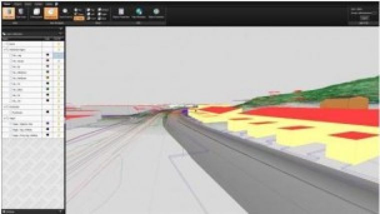
On 12 October 2012, TC5D was released by Adtollo, Sweden. A web interface that allows you to easily view and spin your maps in 3D, directly in your web browser. In addition to the three dimensions there are two more; time and relation.
Adtollo develops software for mapping, design and GIS, and Topocad is the most well-known product. This Monday, TC5D was launched, representing Topocad Collaborator 5 Dimensions. Topocad contains the CAD functions while TC5D's focus is on fast and modern publishing and distribution of map data. TC5D helps the user to visualize the map to the public, the project team, the client or anyone else. Everyone who needs to publish and distribute location-based data is a potential user of TC5D.
The fourth dimension in TC5D is time: The user is able to look at the map: what it looked like in the past, what it looks like now and also what is to come, says Tomas Sandström, director of Surveying & Mapping department at Adtollo. He continues about the fifth dimension: relation. To be more precisely a relation between objects. For example, let’s say you have a pole and a road center in a map: move the road and the pole will follow. But the pole can be moved without the road following, Sandström adds.
Point clouds can be imported in TC5D. Scan of, create a topographic model and publish it directly in the software. Vectors, raster images (regular photos and ortophotos) and terrain models are other types of data that can be published on the web.
The user does not need Topocad for upload. It is possible to upload all kinds of data from many different file formats such as dwg, shape, dgn, xml and others. But with Topocad it is of course easier, just a save button, and today the only option to download data is thru Topocad.
At the moment there are functions for showing object properties from the database. The user can ask for all attributes in the database. There is also a Measure command that measures distances in three dimensions. Sandström says Adtollo has created an API so the user can develop the functionality himself.
Data is stored in a database on the server and you use six different levels of users, from administrators to public. If the user publishes data it is viewable for everyone that can reach the web page. But if data is not published those who have a login to the system will be able to see their part of the map.
As a user, it is a web page, no application. You start and run TC5D directly in your internet browser. The software is built on the latest technology, WebGL. It is developed for web platforms and associated with HTML5. The technique allows you to rotate and view 3D map without a plug-in. This means you can run TC5D in your browser without having to install anything on your computer, Tomas Sandström concludes.

Value staying current with geomatics?
Stay on the map with our expertly curated newsletters.
We provide educational insights, industry updates, and inspiring stories to help you learn, grow, and reach your full potential in your field. Don't miss out - subscribe today and ensure you're always informed, educated, and inspired.
Choose your newsletter(s)


