Aibot X6 UAV Celebrates 5 Years and New Features
Aibotix is presenting the latest innovations in UAV technology in celebration of the five-year anniversary of the Aibot X6 UAV at Intergeo 2016 in Hall A3 (stand D3.033). Aibotix recently introduced the redesign of Aibotix AiProFlight software as well as a broad range of fully integrated standard sensors. At Intergeo 2016, Aibotix is introducing the next step to make the workflow even simpler with three new features to increase productivity and simplify aerial data capture missions.
Since 2011, organisations around the world have come to rely on the accuracy and advanced technology of the Aibot X6 UAV and its accompanying software, Aibotix AiProFlight. Bringing significant reductions in costs and time spent on projects all over the world, both software and UAV have been redefining workflows for aerial data capturing.
The success of UAVs like the Aibot X6 is capturing aerial data as well as saving time and costs. Aibotix have been able to develop new features that complete the system, enabling to offer professionals the opportunity to invest in the latest technology for aerial surveying and inspection.
New Era for Data Acquisition
The new StoreIn Flight option of Aibotix AiProFlight enables users to store up to 1,500 waypoints on the UAV. This feature allows users to upload very large missions and project data with just one click. The option allows to execute missions automatically and independent from battery capacity, saving time and effort.
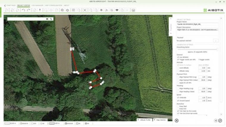
Next, with the TeachIn Flight option, the UAV stores camera and recording position during manual flights, which are the crucial inspection parameters. In a second step, the user can transfer the manual flight into a flight plan for an autonomous flight. This enables users to repeat missions with little planning at the same location at any time, saving time and significantly simplifying data acquisition.
Finally, the viewing module 3D Visual gives pilots a means to visualise their flights in two separate windows - in on-top view and in a height profile. With a more detailed way of planning missions, particularly in rough terrain structures with varying heights or for inspection missions with complex structures.

Value staying current with geomatics?
Stay on the map with our expertly curated newsletters.
We provide educational insights, industry updates, and inspiring stories to help you learn, grow, and reach your full potential in your field. Don't miss out - subscribe today and ensure you're always informed, educated, and inspired.
Choose your newsletter(s)


