Air Pollution Modelling with 3D Visualisation
UK-based environmental engineering company Cambridge Environmental Research Consultants (CERC) has been using the TatukGIS Developer Kernel (DK) ActiveX edition since 2007 to develop the GIS mapping module for its ADMS air pollution modelling software. The mapping module developed from the TatukGIS DK, called ADMS Mapper, is used to visualise and edit input data for the ADMS modelling software.
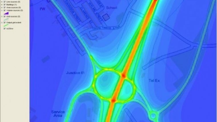
| The Mapper can render pollutant concentrations output from the ADMS model. |
Before ADMS Mapper became available, users of ADMS had to buy third-party GIS software such as ESRI ArcGIS or MapInfo to visualise their modelling scenarios. ADMS is used by hundreds of people in over 30 countries for dispersion modelling of urban air pollution and calculation of air pollution concentrations. Users include regulatory authorities, government organisations, industry bodies, environmental consultancies and academic institutions.
Plug-in GIS Tool
In 2013 CERC updated its Mapper application to use the TatukGIS DK v10 in order to take full advantage of the new 3D mapping capabilities the DK component provides. The new Mapper v2 is now an ActiveX library (DLL) that is installed as a shared component so that it can be used by multiple products CERC develops. Accordingly, the Mapper v2 was released during October-December 2013 with the latest versions of ADMS-Urban, ADMS-Roads, and ADMS-Airport. The flexibility of developing a plug-in GIS tool in-house using the TatukGIS SDK has meant CERC can provide stunning GIS capability in many products quickly and with reduced development costs.
ADMS is used to model the impact of existing and proposed industrial installations with respect to air quality standards such as the EU Air Quality Directive, UK Air Quality Strategy, US National Ambient Air Quality Standards (NAAQS), Chinese Class I, II and III, and WHO guidelines. Typical uses include IPPC authorisations, stack height determination, odour modelling, environmental impact assessments, and safety and emergency planning. Government customers of ADMS within the United Kingdom include the UK Health and Safety Executive (HSE), Environment Agency in England, Natural Resources Wales, Scottish Environmental Protection Agency (SEPA), Department of the Environment in Northern Ireland, and Food Standards Agency in the UK.
More detailed information about CERC and its ADMS software, including the user guide, is available at: www.cerc.co.uk.

Value staying current with geomatics?
Stay on the map with our expertly curated newsletters.
We provide educational insights, industry updates, and inspiring stories to help you learn, grow, and reach your full potential in your field. Don't miss out - subscribe today and ensure you're always informed, educated, and inspired.
Choose your newsletter(s)


