Airbus and Hisdesat Process First TerraSAR-X / PAZ Radar Interferogram
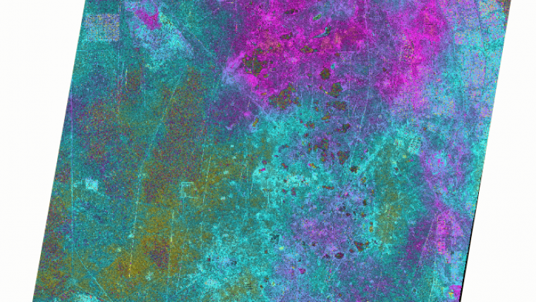
Airbus Defence and Space and Hisdesat Servicios Estratégicos have generated the first joint TerraSAR-X / PAZ Radar Interferogram. This milestone demonstrates the missions’ capacity for cross-sensor interferometry, which is extremely challenging to process. Interferograms are typically used to derive the topographic elevation and deformation of the Earth’s surface, and are created using at least two different images acquired on different dates. This flattened Cross-Sensor Interferogram has been created from a mixed image pair with 4 days temporal separation acquired by TerraSAR-X and PAZ (StripMap scenes from 22 and 26 November 2018). The area covers the oil and gas production site Burgan (Kuwait) and parts of the Persian Gulf. The oil field is the world's largest sandstone oil field with the total surface area of about 1,000 km².
Fast ground deformation monitoring
As PAZ is positioned in the same orbit as TerraSAR-X and TanDEM-X and features exactly identical ground swaths and acquisition modes, they all three form a high-resolution SAR satellite constellation, jointly exploited by Hisdesat and Airbus. With the launch of PAZ, the observation repeat cycle has been divided by half, which improves the monitoring of fast ground deformation phenomena that can endanger lives and infrastructures.
“This is a major step towards achieving the implementation of our TerraSAR-X / PAZ Radar Constellation. The level of accuracy obtained with this interferogram is a guarantee for our customers to continue to rely on the high quality standard we have set with TerraSAR-X and TanDEM-X, but with an improved monitoring capacity,” said Hanjo Kahabka, head of production and radar constellation manager at Airbus Defence and Space, Intelligence.
“At Hisdesat we are very proud of reaching this milestone. Interferometry is one of the most technically demanding applications and thanks to this successful joint exercise with Airbus we have not only demonstrated the top performance of our PAZ satellite but its full compatibility with TerraSAR-X and TanDEM-X. Now operation in constellation can become a reality and we will be able to provide to our customers full set of images and services with the constellation,” said Miguel García Primo, chief operating officer at Hisdesat.

Value staying current with geomatics?
Stay on the map with our expertly curated newsletters.
We provide educational insights, industry updates, and inspiring stories to help you learn, grow, and reach your full potential in your field. Don't miss out - subscribe today and ensure you're always informed, educated, and inspired.
Choose your newsletter(s)


