Before-and-after Satellite Images of Kathmandu Support Earthquake Relief Effort
Following Nepal's devastating magnitude-7.8 earthquake on Saturday 25 April 2015, Airbus Defence and Space has acquired Pléiades satellite imagery to support the International Charter and Copernicus Emergency Management Service. The data acquired will assist in assessing the damage and help rescue organisations in the delivery of humanitarian aid.
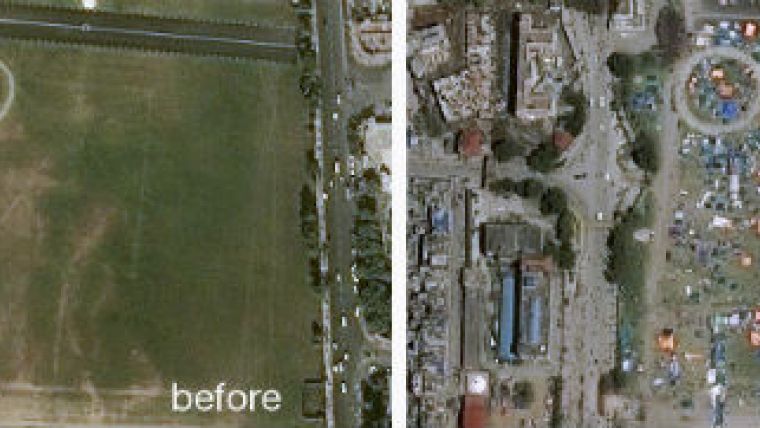
The before-and-after Pléiades images of Kathmandu show the devastation caused by the earthquake. The ‘before’ Pléiades image was acquired on 29 November 2014, and the ‘after’ Pléiades image was acquired on 27 April 2015, two days after the earthquake.
Interactive Maps
Esri has published a pair of interactive maps about the earthquake and aftershocks that struck Nepal over the weekend. The following maps are available for the media to embed or share as part of ongoing coverage.
Explore the locations and intensities of the various quakes that struck Nepal, along with a shakemap from the USGS. This map also includes geotagged social media from Twitter and YouTube with local content related to the quakes.
Mapping the 2015 Nepal Earthquake
Take a closer look at Nepal’s history of seismic activity and learn more about the people impacted by the earthquakes. This story map also includes information about relief operations and key points of interest in the region, as well as a 3D web scene of the area affected by the avalanche on Mt. Everest.

Value staying current with geomatics?
Stay on the map with our expertly curated newsletters.
We provide educational insights, industry updates, and inspiring stories to help you learn, grow, and reach your full potential in your field. Don't miss out - subscribe today and ensure you're always informed, educated, and inspired.
Choose your newsletter(s)


