Bentley Systems Acquires Plaxis and Soilvision to Enrich Digital Workflows
Bentley Systems, a global provider of comprehensive software solutions for advancing infrastructure, has announced the acquisition of Plaxis, a provider of geotechnical software, based in Delft, The Netherlands. Bentley has also announced an agreement to acquire soil engineering software provider SoilVision, based in Saskatchewan, Canada. The acquisitions, with Bentley’s leading borehole reporting and data management software gINT, will serve to make Bentley a complete source for geotechnical professionals 'going digital'. Finally, BIM advancements can be extended to the essential subsurface engineering of every infrastructure project.
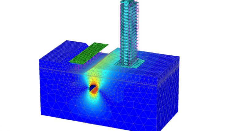
Projects necessarily begin with geotechnical surveys and sampling, captured with gINT for versatile documentation and reporting. Next, professionals perform engineering related to soil properties, soil behaviour, and groundwater flow using SoilVision’s SVOFFICE applications, supplemented by Plaxis’ offerings. Then soil-structure interaction is analysed through Plaxis’ design, simulation, and engineering software (e.g. PLAXIS 2D, PLAXIS 3D).
Geotechnical analysis
The new opportunity, by way of digital workflows enabled through Bentley’s comprehensive modelling environment, is for geotechnical applications to be integrated with Bentley’s structural applications (such as STAAD, RAM, and SACS) for first-rate geo-structural engineering performance. As changes may occur in owner requirements, structural strategies, or site conditions (continuously surveyed through UAVs and Bentley’s ContextCapture for reality modelling), geotechnical analysis could be continuously applied for improved outcomes, as managed through ProjectWise collaboration services.
For today’s infrastructure demands, geotechnical considerations are coming to the fore. Urbanisation, for instance, drives growth both vertically and underground, with emphasis on the capacity of foundations and tunnels. And new infrastructure projects of every type depend upon constructed dams, embankments, dikes, levees, and reservoirs to improve their resilience. Moreover, new asset types such as offshore wind turbine structures require new geotechnical analysis capabilities, in this case to be accomplished with Plaxis’ forthcoming MoDeTo software.
Real-time monitoring
Because infrastructure assets are crucially linked to subsurface environs, they are vulnerable to geo-environmental risks including seismic activity, subsidence, and weather impacts. Leveraging new digital workflows which incorporate real-time monitoring and analytics during infrastructure operations, geotechnical professionals can play the increasingly valuable role they deserve in achieving geo-environmental resilience.
Bentley Systems CEO, Greg Bentley said his colleagues and himself welcome the new teams from Plaxis and SoilVision, which have in common a zeal for applying science for better engineering practice. Dr Ronald Brinkgreve from Plaxis and Dr Murray Fredlund, founder of SoilVision, exemplify this. He believes that every geotechnical engineer has benefitted from Plaxis’ continuous advancement, in scope and quality, of tools for their discipline to add value. With a professional and dedicated management team led by Jan-Willem Koutstaal, Plaxis has become one of the most successful software businesses Greg Bentley has ever seen.
Embracing geotechnical profession in digital workflows
Bentley added that while most infrastructure engineering disciplines converged around intuitive 3D models, geotechnical applications seem to have followed a less graphically intensive development path, and so have remained isolated from cross-discipline workflows. This ‘disconnected’ mindset prevailed even while Plaxis, SoilVision, and gINT mainstreamed 3D innovations. Bentley Systems’ BIM platform’s comprehensive modelling environment will finally embrace the geotechnical profession in digital workflows for every infrastructure project and asset, Greg Bentley concluded.
Tony O’Brien, global practice leader for geotechnics for Mott MacDonald, said PLAXIS is one of the core analysis tools being used across the global geotechnics practice. When used by experienced specialists, PLAXIS can analyse many of our most complex ground-structure interaction problems. O’Brien believes that in Bentley’s hands, they have high expectations that we can accomplish more through digital workflows made possible through integration of PLAXIS technology with Bentley’s comprehensive modelling environment – workflows that are compatible with Mott MacDonald’s commitment to connected thinking and solving complex infrastructure challenges.

Value staying current with geomatics?
Stay on the map with our expertly curated newsletters.
We provide educational insights, industry updates, and inspiring stories to help you learn, grow, and reach your full potential in your field. Don't miss out - subscribe today and ensure you're always informed, educated, and inspired.
Choose your newsletter(s)


