Best Practices and Inspiring Ideas for Land Administrators
According to Wikipedia, “a cadastre (also spelled cadaster), using a cadastral survey or cadastral map, is a comprehensive register of the real estate or real property’s metes-and-bounds of a country”. Many countries use the cadastre to define the dimensions and location of land parcels described in legal documentation, which makes it a key source of data in land disputes. A well-functioning cadastre is a fundamental pillar of the economic policy and as such represents an essential ingredient for a country to work on improving its prospects. ‘GIM International’ frequently publishes articles about various methods that can be used to set up such a cadastral system. We have selected this list of articles that may inspire land administration professionals.
The Necessity of a Modern Cadastral Systems
A well-functioning land administration system, or cadastre, is the foundation of national stability and social welfare. A government can make a thousand promises or grandly announce a comprehensive vision to boost the country’s economy, but without an efficient and effective cadastral system the authorities will never be able to deliver. When considering the economic status of a country, it is wise to zoom in on the progress of its land administration policy. The relationship between land administration and prosperity/growth is evident. Read more...
Geomatics and Surveying in Support of Land Administration
Today’s geospatial technology means that land administration systems can increasingly be implemented for the benefit of all. It is now possible to conceive approaches to capturing the unrecorded geometry of boundaries for the billions of unrecognised land interests or spatial units. In addition, new approaches are becoming apparent for the maintenance of collected data. Examples from the field show that we’re well on the way to responding to the challenge. From a geomatics and geoscience perspective, many tools are already available to support development, but further steps are needed to operationalise them at scale. Read on for an article investigating a few of the emerging options. Read more...
Apps for Land Administration
The use of community participation, mobile technologies and cloud storage services could create a new way of undertaking land administration activities, and ultimately lead to more secure land rights for all. Sparked by these grand visions – which were first promoted by Robin McLaren, amongst others, in the late 2000s – alternative land administration platforms are now emerging, such as cadasta.org, landmapp.net and mobineo.org to name but a few. Apps lie at the heart of the developments…but what do we really mean by a ‘land administration app’ and what must such an app be capable of? Here, the authors provide a brief overview. Read more...
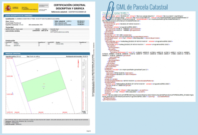
Smart Cadastral Tools for Real Estate Registration
The tools, systems and protocols as developed by the Spanish Directorate General for Cadastre are well accepted and widely used. A smart system of coordination between the Cadastre and the Property Rights Registry in Spain is now working and showing results. Agents working in the real estate market are now involved too. In Spain, the Cadastre and the Property Rights Registry are two separate institutions with differentiated mandates and competences, both working in the domain of land administration. The Spanish Law 13/2015 implements an effective coordination of transactions executed by both institutions. Today the real estate transactions are performed with increased legal certainty. While georeferenced spatial information of parcels is incorporated into the Property Rights Registry, cadastral mapping forms the basis of the graphic representation used. The cadastral data is updated simultaneously with the Property Rights Register. Read more...
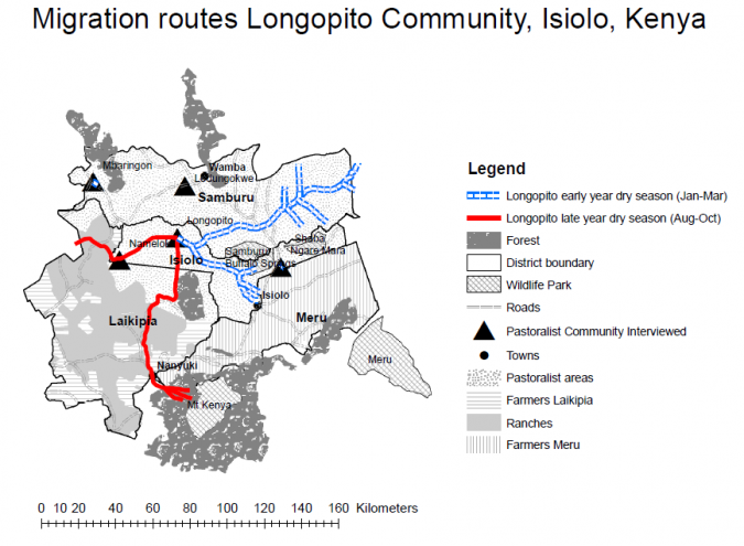
Innovative Tools for Tenure Recordation
Aimed at protecting the land rights of underrepresented citizens, fit-for-purpose land administration promotes alternative approaches to facilitate aiding and improving land tenure security based on the Social Tenure Domain Model (STDM). This article examines innovative tools and technologies for documenting overlapping and secondary land rights that formal land registration systems fail to take into account. Read more...
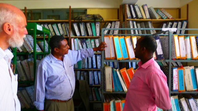
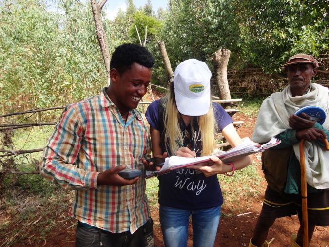
Implementing Land Administration Solutions in Ethiopia
The government of Ethiopia has demonstrated clear political will to advance the urban land rights agendas, but has struggled to sustain successful pilots. In a recent Technical Assistance project, a World Bank team including consultants from Land Equity International worked closely with the Ministry of Urban Development and Housing to evaluate the urban cadastral context. Read more...

Need for New Players and Leaders to Enter the Land Sector
Dr Robin McLaren is a widely known and recognised authority with more than 30 years of experience in the profession. Having developed GIS technology for a number of years, Robin set up his independent consulting company, Know Edge Ltd, in Edinburgh in 1986, providing GIS solutions for governmental and utilities clients across the United Kingdom. Following an introduction to international land administration and management during a UN-FAO mission to North Yemen in 1989, this became a major market for the company. GIM International interviewed Robin to learn more about his involvement in many innovations and to hear his insightful opinions. Read more...
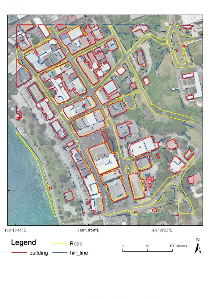
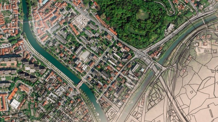
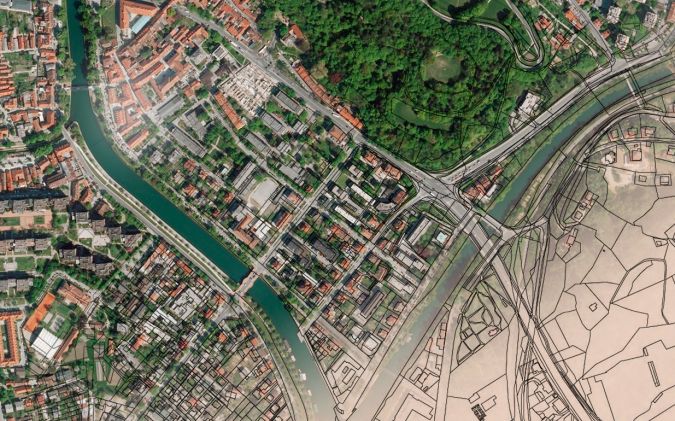
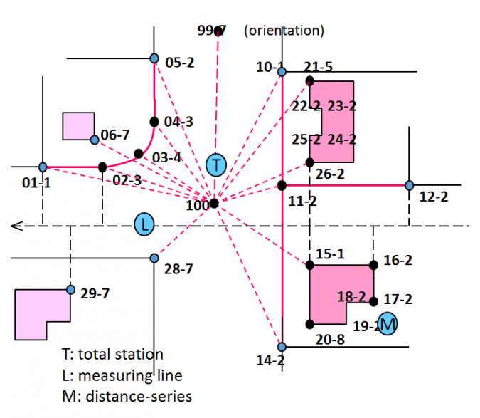
Cadastral Boundaries from Point Clouds?
Proponents of the new era for land administration argue that countries must explore alternatives to accelerate land administration completion. As an example, fit-for-purpose land administration is based on the use of printed imagery, community participation and hand-drawn boundaries. Digital solutions then convert the generated analogue data into useful digital information. However, the approach is manually intensive, and simple automation processes are continually being sought to cut time and costs. One approach gaining traction is the idea of using image processing and machine learning techniques to automatically extract boundary features from imagery – or point cloud data – prior to even entering the field. The approach could speed up activities both in the field and in the office. Read on for insight into the ongoing developments. Read more...

Value staying current with geomatics?
Stay on the map with our expertly curated newsletters.
We provide educational insights, industry updates, and inspiring stories to help you learn, grow, and reach your full potential in your field. Don't miss out - subscribe today and ensure you're always informed, educated, and inspired.
Choose your newsletter(s)


