Bluesky and University of Leicester Partner in Lidar for Detailed Tree Analysis
This article was originally published in Geomatics World.
Bluesky International is co-funding research into the use of Lidar, machine learning and artificial intelligence to create citywide maps of trees enriched with new levels of information in an advanced postgraduate degree study in partnership with the UK’s University of Leicester.
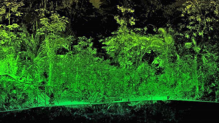
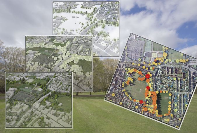
A specialist in aerial mapping, Bluesky use aircraft mounted lasers (Lidar) to capture millions of highly accurate measurements called point clouds that detail the earth’s surface and features. Bluesky has already pioneered nationwide maps detailing the location, height and canopy cover of trees and this R&D project is expected to result in an automated workflow for the extraction of tree structural features and the classification of tree species.
Automated algorithms
“We have recently upgraded the sensor used to capture Lidar point clouds so we have more detailed and accurate measurements than ever before. We are therefore exploring how artificial intelligence and machine learning can be applied to extract additional intelligence from this data in the most efficient, accurate and cost-effective way,” commented James Eddy, technical director at Leicestershire based Bluesky.
“By partnering with the University of Leicester we hope to exploit its expertise across natural science and data science to develop automated algorithms for processing this data to identify specific tree structures and classify species to augment our National Tree Map datasets.”
“The characterization of tree structural features is important for ecological, climate change with respect to changes in above-ground biomass and environmental studies,” added Prof. Kevin Tansey, University of Leicester School of Geography, Geology and the Environment. “We therefore have an interest in using advanced observational technologies to understand how we can extract meaningful information about the properties of trees.”
High-density point cloud processing
Prof Ivan Tyukin, University of Leicester School of Mathematics and Actuarial Science commented: “Artificial Intelligence approaches are proving versatile enough to be used in a wider variety of application domains. By partnering with Bluesky to offer this opportunity we can ensure the study benefits from the most accurate and up-to-date source material available and the experience and expertise used to create the National Tree Map.”
The Bluesky proposed study, titled ‘High-density point cloud processing for tree structural features extraction and species classification’, will result in a Master of Philosophy (MPhil) qualification. Offered by Leicester Innovation Hub, part-funded by the European Regional Development Fund, and delivered by the School of Mathematics and Actuarial Science and the School of Geography, Geology and the Environment at the University of Leicester, it is hoped the outputs of the project will include an annotated software code for tree identification, feature extraction and species classification, and a synthetic technical documentation on its algorithmic.
Prof Ian Gillespie, University of Leicester Pro-Vice-Chancellor, Research and Enterprise, concluded, “The Leicester Innovation Hub is working with SMEs and the academic departments to facilitate the translation of cutting-edge research results into products and services, foster innovation and enable economic growth. Bluesky is an excellent partner, and we are proud to add another layer of collaboration.”

Value staying current with geomatics?
Stay on the map with our expertly curated newsletters.
We provide educational insights, industry updates, and inspiring stories to help you learn, grow, and reach your full potential in your field. Don't miss out - subscribe today and ensure you're always informed, educated, and inspired.
Choose your newsletter(s)


