
The Rotterdam 3D city model
3D digital twin: urban IT crossover of interconnections
The Dutch city of Rotterdam is developing a digital twin of the city aimed at improving the efficiency of urban planning and management.
If 3D is becoming the new normal in spatial data infrastructures, how can it be used in an urban environment? The Dutch city of Rotterdam, known as home to the largest port in Europe, is preparing for that next step by developing a digital twin of the physical city. The primary aim of ‘Digital City Rotterdam’ is to improve the efficiency of urban planning and management. But at the same time, the city council is on the lookout for applications that will help people integrate the digital world into their real one – or will it be the other way around in the not-so-distant future?
What will the inhabitants of Rotterdam expect of their city in a couple of decades’ time? According to the figures, 60% of the 650,000 inhabitants are active on the labour market, more than half are single or a single parent, and 30% are under 25 years old. Unfortunately, these statistics tell us nothing about how people interact with the physical infrastructure and with each other. But the dynamics are clearly changing, says Roland van der Heijden, programme manager of ‘Digital City Rotterdam’: “The city has long thrived on the interaction between people and the physical environment. But now this reality is under pressure from several major changes – just think about how we shop, work, find our way around, use our free time, communicate and so on. We want to facilitate the citizens of Rotterdam by building a digital urban platform. Two years ago we were working on 350 so-called ‘smart city projects’. But even if we do a thousand such projects, that still doesn’t make Rotterdam a smart city if they are not interconnected – and they weren’t, so that is where it all started.”
Open data standards
The platform is intended to interconnect as many Rotterdam-related applications as possible making use of open data standards. It should present a continuous image of the current, measurable physical reality. How many cars are driving through a particular street? Is a specific parking space occupied? How many people are in a certain area? Are streetlights not working? Are communal rubbish bins full? What is the current air quality?
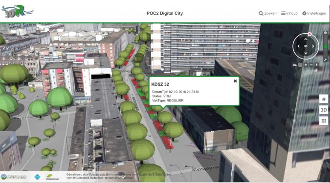
Since most applications have a location component, a 3D object-oriented data model of the physical reality is the most efficient approach for this ‘digital twin’. The topographic 3D basic registration is under construction. The buildings are ready (although individual accommodation units in apartment blocks still need to be discerned) and are available for everybody to connect their data to. It is designed as a smart query environment (“contrary to Google Earth”). More and more objects such as lamp posts, street furniture and communal rubbish bins are also available in 3D. But conversion remains a serious challenge in connecting data that used to be in separate compartments. Van der Heijden: “Commercial parties had no interest in writing their applications in a language everybody could understand. It took us some time to win the battles to change that. Now, every new contract specifies our data standard and the companies have to comply. Most companies are willing to supply their data as a service, but we still have to convert it to enable other parties to use it via the digital twin platform to build information services. We work with the likes of City GML, BIM-IFC, WFS and Sensorthings API, depending on the data concerned. The platform will have software which can connect BIM to sensor data, for example, in such a way that it remains open. Moreover, GIS data need extra work, even if the supplier plays a major role in the international open-data arena. Most software can handle all kinds of data formats as inputs, but extracting it is a different story and you often need to pay for help. So with GIS we’re falling back on the WFS standard.”
No grand design
The strategy for winning this war on compartmentalization is focused on avoiding a top-down ‘grand design’. “Such designs are like works of art – with their arrows, trapeziums and webs, they are almost fit to hang on your wall at home, but they are too complex to be implemented. And by the time everyone has finally reached agreement, you can start again because the technical design is already outdated. As technicians we can also make things extremely ‘advanced’, leading to systems in which you get lost in the countless possibilities. On the other hand, listening only to your potential customers doesn’t work either. They tend to focus on making minor changes to what they currently use, which misses the big picture and results in just a little tweaking based on today’s problems. In Rotterdam we are always on the lookout for a ‘coalition of the willing’ to ensure sufficient energy to play this iterative game between the demand side and the supply side,” the programme manager continues. “We respect the autonomy of the various city departments and therefore do not want to change their processes, dashboards or data silos, but they have to make doors in those silos to automate the extraction of their data into an open data standard, and also in real time if it concerns real-time data.”
His team of ten can devote half their time to the digital platform. For now, they are focusing on ten functionalities: conversion, API strategy, safety & privacy, viewing (3D digital twin), connection to other initiatives in the country, data market function to balance data demand and supply, rules around ownership and platform governance, (meta)data & applications, data storage, and geofunctionality. But is geofunctionality still a separate item for an urban data platform in this day and age? “All other Dutch urban open data platforms I know of function as a data hub without geofunctionality. In Rotterdam we’re explicitly making sure a location component is possible in every dataset,” he answers.
Business case
Data storage is another interesting issue. Over the coming years, every local civil servant, business and citizen will be stimulated to use the platform. Cloud storage is inevitable in order to handle the exchange of such massive amounts of data. What role should a governmental organization want to play in the infrastructure? Are the Chinese or American governments a good example? Or can this digital twin of everything that takes place in the city be entrusted to the private sector? “Several European and world-leading companies have visited us at our city hall with fantastic presentations. They want to install all the necessary network infrastructure, manage all the data – everything you can think of, and for free. A ‘platform as a service’ sounds very attractive to our managers, who are always in search of ways to save costs. But in Rotterdam we realized that such a setup, in which a commercial firm gets to be the middleman of all data flows, makes the city a powerless customer of its own data. There would be more safety, privacy and financial concerns than when the local authorities would retain governance of the digital city,” says Van der Heijden, summarizing the deliberations. That does not mean the platform’s business case is simple; it is not merely regarded as an investment for the city overall, but is also expected to make some profit. In a few years’ time, he expects that the platform will probably have some customers who sell information services. Those services could be in real time, but could also be based on the use of artificial intelligence to analyse trends.
Applications
The generic platform will be released in 2022. The first two proofs of concept have been successful and just one more has to be completed before the system can be built. The first applications will relate to building permits. Another early application will use augmented reality. People will be able to scan QR codes on information panels at building sites and see the BIM model of the new building materializing on their screen as they point their smartphone at the construction area. A third application concerns time and place-independent participation by citizens in urban development projects based on gamification. People have to take into account the consequences of their choices and will be able to virtually move through the 3D environment they co-created. So far, functionalities like these have been stand-alone applications. “But in the near future the digital city will be an IT ecosystem in which we can do such things from behind our desks. It is a crossover of interconnections, all based on the same view of reality,” he comments.

To illustrate the situation, Rotterdam – which is located five metres below sea level – has an effective 3D e-water model showing how the city would flood if a particular dike were to be breached, and it also has a successful traffic model. But to see which roads should be used during evacuation in the case of flooding, an extra application is needed that combines those two data models. Another benefit of an easy crossover is that it can open up new and often surprising possibilities. Sensors have been installed in communal rubbish bins that indicate how full they are, for example. When the managers of Rotterdam’s home-care organizations discovered that such data existed, they instantly realized they could put it to good use. Home-care professionals work to a very tight schedule. When taking the trash out to the communal bin for their customers, it can save them valuable time and energy if they know beforehand that the closest option is full and where the best alternative is located.
Next generation
Roland van der Heijden illustrates the necessity of more fluid boundaries between the social, physical and digital environments with an example relating to Rotterdam’s young people. Community workers signal a fast-growing percentage – in some areas more than half – of the city’s youngsters withdrawing from physical and social life in their own neighbourhood. While they might attend school locally, due to social media and online gaming they form part of a digital community and their friends are not next door but around the world. “If a growing section of the population is spending more and more time in a ‘virtual’ world, what will that mean for Rotterdam in 25 years’ time? And what does that mean for the functionalities they will look for on a digital city platform?” he asks. “A platform programmed according to our reality will not relate to how people live in 2045. We can’t even ask ourselves the right questions. We look at the city and see it as we have always known it, plus some extra digital options. But that’s not the city of the future; it is beyond a new layer. In the future, most people will largely live in the digital reality, which will be interwoven with everything you can imagine. And that’s what we have to try to anticipate.”

Value staying current with geomatics?
Stay on the map with our expertly curated newsletters.
We provide educational insights, industry updates, and inspiring stories to help you learn, grow, and reach your full potential in your field. Don't miss out - subscribe today and ensure you're always informed, educated, and inspired.
Choose your newsletter(s)


