Drought Monitoring Using Gravity
The record-breaking drought in Texas, USA, that has fuelled wildfires, decimated crops and forced cattle sales has also reduced groundwater levels in much of the state to their lowest levels in more than 60 years, according to new national maps produced by NASA using data from the NASA/German Aerospace Center Gravity Recovery and Climate Experiment (Grace) mission. The map are distributed by the National Drought Mitigation Center at the University of Nebraska-Lincoln.
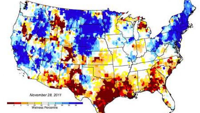
The latest groundwater map, released at the end of November 2011, shows large patches of maroon over eastern Texas, indicating severely depressed groundwater levels. The maps, publicly available on the Drought Center's website, are generated weekly by NASA's Goddard Space Flight Center in Greenbelt, Md., using Grace gravity field data calculated at NASA's Jet Propulsion Laboratory, Pasadena, Calif., and the University of Texas Center for Space Research, Austin.
Matt Rodell, a hydrologist based at Goddard, expects that Texas groundwater will take months or longer to recharge. Most of the water runs off, he reckons. It takes a longer period of sustained greater-than-average precipitation to recharge aquifers significantly.
The twin Grace satellites, which JPL developed and manages for NASA, detect small changes in Earth's gravity field caused primarily by the redistribution of water on and beneath the land surface. The paired satellites travel about 137 miles (220 kilometres) apart and record small changes in the distance separating them as they encounter variations in Earth's gravitational field.
To make the maps, scientists use a computer model that combines measurements of water storage from Grace with a long-term meteorological dataset to generate a continuous record of soil moisture and groundwater that stretches back to 1948. Grace data go back to 2002. The meteorological data include precipitation, temperature, solar radiation and other ground- and space-based measurements.
The colour-coded maps show how much water is stored now as a probability of occurrence in the 63-year record. The maroon shading over eastern Texas, for example, shows that the level of dryness over the last week occurred less than two percent of the time between 1948 and the present.
The Drought Center also distributes soil moisture maps that show moisture changes in the root zone down to about 3 feet (1 metre) below the surface, as well as surface soil moisture maps that show changes within the top inch (2 centimetres) of the land.
Drought Center's Brian Wardlow says that all of these maps offer policymakers new information into subsurface water fluctuations at regional to national scales that has not been available in the past. The maps provide finer resolution or are more consistently available than other similar sources of information, and having the maps for the three different levels should help decision makers distinguish between short-term and long-term droughts.
The maps also offer farmers, ranchers, water resource managers and even individual homeowners a new tool to monitor the health of critical groundwater resources. People rely on groundwater for irrigation, for domestic water supply, and for industrial uses, but there's little information available on regional to national scales on groundwater storage variability and how that has responded to a drought. Over a long-term dry period, there will be an effect on groundwater storage and groundwater levels. It's going to drop quite a bit, people's wells could dry out, and it takes time to recover.
The maps are the result of a NASA-funded project at the Drought Center and NASA Goddard to make it easier for the weekly U.S. Drought Monitor to incorporate data from the Grace satellites. The groundwater and soil moisture maps are updated each Tuesday.
http://grace.jpl.nasa.gov/

Value staying current with geomatics?
Stay on the map with our expertly curated newsletters.
We provide educational insights, industry updates, and inspiring stories to help you learn, grow, and reach your full potential in your field. Don't miss out - subscribe today and ensure you're always informed, educated, and inspired.
Choose your newsletter(s)


