Enabling Faster, More Effective Response to Crisis Events
DigitalGlobe has launched two new geospatial intelligence (GEOINT) services at GEOINT 2011: FirstWatch and FirstLook. Both services are designed to enable faster response, smarter decisions, and more effective management of on-the-ground personnel during natural and man-made disasters.
The first new solution, DigitalGlobe FirstWatch, is a rapid analysis and reporting service designed to help users more quickly assess and formulate response strategies following natural and man-made disasters.
When a crisis event occurs, the DigitalGlobe FirstLook service is activated and begins collecting new imagery from the affected region. Immediately after new imagery is downloaded, experts in the DigitalGlobe Analysis Center begin rapidly analysing the images, publishing a comprehensive DigitalGlobe FirstWatch report within hours after the event occurs.
Reports include a wide-range of information to assist humanitarian relief personnel assess the scope and magnitude of the event and start formulating the most effective response plan. They identify key details on the ground, including evidence of structural damage, infrastructure failures, changes to topography, flood water depth and other potentially life-threatening elements.
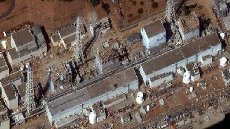
To date, DigitalGlobe has produced reports for more than 50 events worldwide, including the earthquake and subsequent crisis events in Japan, and the impact of Hurricane Irene and Midwest flooding in the U.S. The latest report examples and excerpts can be found at www.digitalglobe.com/firstwatch.
In addition to launching the DigitalGlobe FirstWatch reporting service, the company also jointly unveiled the new Diplomatic Facilities Support Package with partner CACI International Inc.
The package is designed to help governments more quickly and effectively respond to threats to diplomatic facilities and citizens abroad. It dynamically combines DigitalGlobe's sub-metre resolution imagery with CACI's geospatial feature content to provide users with a current view of geographical landscapes, structures, routes and roadways, and critical resources. It provides virtual whiteboards and annotation tools, allowing users to layer additional data on top of existing content and customise information, then share their whiteboards securely with other users of the service.
Users have the flexibility to access the full functionality though a wide range of devices and computing platforms, including any current web browser running on desktop, laptop or most handheld devices.
The solution also features integration with DigitalGlobe's FirstLook crisis event monitoring and image delivery service. When viewing an area of interest in the Diplomatic Facilities Support Package interface, users are alerted with unique on-screen icons when DigitalGlobe FirstLook imagery becomes available for the region. Subscribers can then select DigitalGlobe FirstLook service from the list of available content layers, instantly replacing the existing basemap imagery with new DigitalGlobe FirstLook imagery captured within hours after the event occurs.
Demonstrations of the Diplomatic Facilities Support Package will be taking place at the DigitalGlobe booth #337 and the CACI booth #273. For more information, visit www.digitalglobe.com/dipfac.
Image Courtesy: DigitalGlobe

Value staying current with geomatics?
Stay on the map with our expertly curated newsletters.
We provide educational insights, industry updates, and inspiring stories to help you learn, grow, and reach your full potential in your field. Don't miss out - subscribe today and ensure you're always informed, educated, and inspired.
Choose your newsletter(s)


