French Experiences with UAV Lidar for Power Line Inspection
RTE, the electricity transmission system operator of France, is in charge of maintenance and repairs for over 100,000km of electricity power lines. When the company started to consider solutions to complement helicopters, it chose Delair to deliver the solution to map and digitize power line corridors: a fixed-wing drone equipped with Lidar. Data from Lidar sensors is now at the core of its vegetation encroachment detection process. Here, RTE UAV pilots share their experiences with aerial Lidar data acquisition technology.
RTE manages power line inspection with Lidar drone to detect vegetation encroachment. Its mission is to direct the flow of electricity and maximize power system efficiency for their French customers. As the owner of the biggest transmission network in Europe, being able to monitor their entire network to spot vegetation encroachment is a critical task to their core activities. The French initially started a helicopter programme to monitor vegetation encroachment, but to improve productivity and costs they turned to drone technology.
Point cloud density
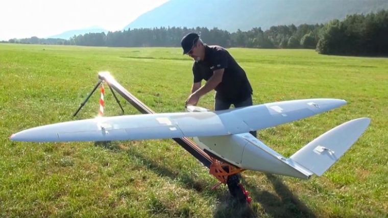
To meet their requirements regarding point cloud density, RTE choose Delair’s DT26 drone which contains a Lidar sensor from RIEGL. This long-range fixed-wing UAV is also BVLOS – Beyond Visual Line Of Sight – certified by the French Civil Aviation Authority (DGAC). That’s definitely a key criterion for mapping several thousand kilometres of transmission lines managed by RTE.
Lidar data is used to create digital terrain models and digital surface models of the power line corridors. The models are pushed into RTE’s maintenance and engineering tools to perform different calculations. The most important one is the proximity calculation between vegetation and power lines. These insights enable RTE to improve the loggers’ efficiency. They can spot exactly where to go and where to cut in order to meet the safety clearance zones around the lines.
Corridor mapping requirements
RTE’s drone pilots agree that the Delair DT26 Lidar UAV meets their requirements for corridor mapping of power lines, as it covers a broad band that captures the power line and all the underlying vegetation.
Here is how it works for high voltage line mapping: The DT26 flies a 30km round trip, starting from the middle and flying 15km on each side. The DT26 Lidar is self-sufficient to perform the 60km-long flights RTE needs.
Flying the drone requires a bit of preparation. Before going in the field, the drone pilots have to find a suitable spot for take-off and landing, not too far from a high voltage line. Their main concern is to avoid flight restricted areas (around airports for example) and ensure good radio link quality between the drone and the base-station.
The UAV pilots of the electricity transmission system operator highly appreciate the check-list in the DT26’s flight management software, which helps avoid forgetting any steps before the launch. They also like its user-friendly interface to define waypoints, adjust flight attitudes and make flight planning quick and easy.
RTE drone pilots plan their flight by importing their power lines in KML format in the flight software. The poles are then represented on the background map, so they can place the waypoints in just a few clicks. The DT26 works in autopilot mode, and the pilots just have to watch the control screen to see the real-time trajectory of the drone along the power lines.

Value staying current with geomatics?
Stay on the map with our expertly curated newsletters.
We provide educational insights, industry updates, and inspiring stories to help you learn, grow, and reach your full potential in your field. Don't miss out - subscribe today and ensure you're always informed, educated, and inspired.
Choose your newsletter(s)


