GPS-Photo Link Version 5.0
GeoSpatial Experts will introduce GPS-Photo Link 5.0 at the 2010 ESRI International User Conference. The new version of GPS-Photo Link is more robust, handles location data in any GPS format, and offers a wider variety of photo-mapping functionality in an easy-to-navigate interface that enables users to manage larger projects.
"GPS-Photo Link 5.0 outputs to ESRI Enterprise Geodatabases, Access files and PDF files as well as ESRI Shape Files, Google Earth, Word and Web pages available in previous versions," said GeoSpatial Experts President Rick Bobbitt. "The new interface is more interactive, allowing users to apply a variety of mapping functions to their photo project and preview the results on a live digital map before generating the final output."
GeoSpatial Experts will demo GPS-Photo Link 5.0 in booth 2418 at the ESRI International Users Conference being held 12th to 16th July 2010, at the San Diego Convention Center in California. In addition, GeoSpatial Experts will hold a drawing for a GPS-Photo Pro 2504 bundle that includes GPS-Photo Link software and a Ricoh 500SE GPS-equipped camera.
GeoSpatial Experts introduced GPS-Photo Link as the first photo-mapping software in 2001. Known for its consistency and reliability over the past decade, GPS-Photo Link has emerged as the industry standard solution for mapping ‘geotagged' photographs. The software has been selected by several camera manufacturers, including Ricoh, Nikon and Sony, for bundling with their hardware.
Version 5.0 includes the following enhancements:
•ArcGIS Extension - Users can access the full functionality of GPS-Photo Link from inside the ESRI ArcGIS environment.
•Blue Marble Conversion - Integrated tools licensed from Blue Marble enable GPS-Photo Link users to convert coordinate points to and from any map projection and datum.
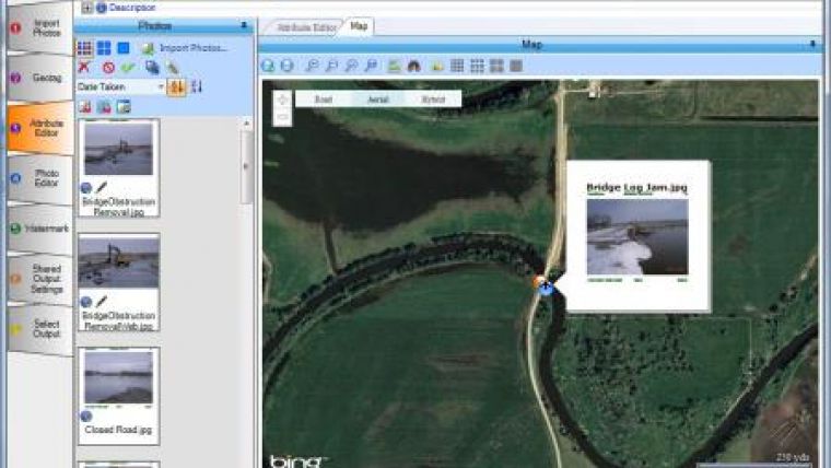
•Live Map Preview - Prior to creating outputs or reports, users can preview and edit photo locations in Bing Maps. Attributes can now also be edited individually or in batches.
•Advanced Photo Editing - Users may edit, crop, annotate and draw on their photos, as well as add a variety of watermarks using any photo attribute (title, date, photographer, etc.).
•Enhanced Outputs - Mapped photos can be output as an ESRI Shape File, ESRI Personal Geodatabase, ESRI File Geodatabase, ArcSDE Enterprise Geodatabase, and Access database. Maps may also be saved as reports in several document formats including Word, PDF, .csv and Web pages (through Crystal Reports).
•Project Management - GPS-Photo Link keeps track of photos, map layers and other data in project folders, making it easier to access, share and assemble documents relating to a specific job or date. Save your settings in a template for future projects.
GeoSpatial Experts offers GPS-Photo Link in two editions - GPS-Photo Link: GIS Pro for geospatial professionals mapping their photos in a true GIS environment such as ArcGIS; and GPS-Photo Link Express for business users who map photos on a digital or web-based map and generate reports from their photo inventories. All enhancements in Version 5.0, with the exception of ArcGIS-related capabilities, are available in both editions.

Value staying current with geomatics?
Stay on the map with our expertly curated newsletters.
We provide educational insights, industry updates, and inspiring stories to help you learn, grow, and reach your full potential in your field. Don't miss out - subscribe today and ensure you're always informed, educated, and inspired.
Choose your newsletter(s)


