How Can Healthcare Professionals Use Geospatial Data to Their Advantage?
Case: COVID-19
The annual influenza season affects millions of people around the globe, and this is now being compounded by COVID-19. Scientists and data engineers are finding new ways of fighting these problems. Geospatial data provides important building blocks for working on better solutions to overcome the challenges of a virus outbreak. Combined with machine learning, promising applications of geoinformation are within reach for authorities and healthcare organizations around the globe.
Healthcare is something that we pour huge amounts of resources into each year, yet we are still unable to tackle common problems like the spread of viral infections (i.e. COVID-19), or to fight influenza efficiently using data-driven decision-making. With the latest developments in data analytics and open data sources, organizations around the world are taking promising steps towards achieving better options.
Identifying the Right Data to Help Tackle COVID-19
There are hundreds of different kinds of data sets available that could be useful in fighting COVID-19 (commonly known as the coronavirus). However, sorting out which ones are the most suitable is a crucial task. You therefore first need to ask yourself, “What will the data be used for?”, so that you can pick out the most important data for you.
You might need more general data about healthcare operations, location of housing, hospitals and airports, demographic data about where people live or information on mobility, or data about how past viral infections have spread. Try to narrow down these data sets to just a few that are the most relevant for your needs.
Whatever you plan to use the data for, focus on national data sets. National organizations provide data that is regulated in terms of quality, which makes these data sources reliable. You can browse various open geospatial web services, such as Spatineo Directory, which is a free catalogue of all the open geospatial web services we have discovered.
One data source that has to be mentioned when writing about COVID-19 is a map layer by John Hopkins University. The data layer is maintained by JHU’s Center for Systems Science and Engineering. It tracks known COVID-19 cases at the country (and in some countries the provincial) level. The data contains confirmed cases, deaths and the number of people who have recovered from the virus. This data set is currently used for example by the Finnish newspaper Helsingin Sanomat and the BBC News. You can check JHU’s github repository for more information about the dashboard and its data.
Once you have found a couple of reliable sources you can work with, it’s time to get creative.
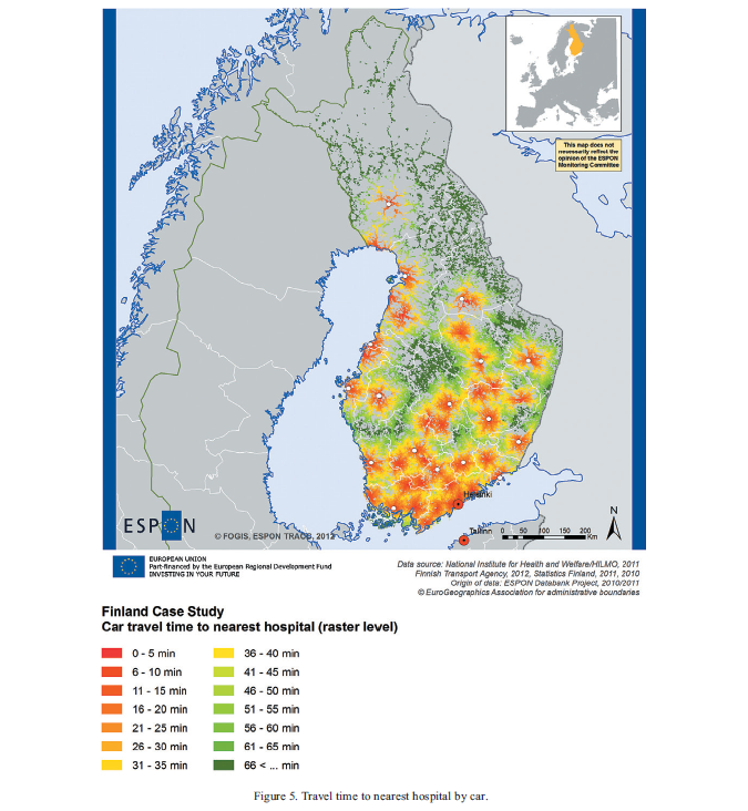
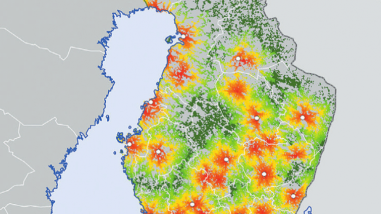
How Long Will It Take for You to Get to a Hospital and How Many Airports Are There in Your Area?
Diseases often spread more readily in high population density areas, and in places close to airports. Living in close proximity to an airport has been proven to have an effect on your chances of catching a viral infection. As we are seeing with the spread of COVID-19, the global outbreak took place within a couple of weeks, probably through air travel.
So (in this example), now that you have data about the location of your country’s hospitals and airports, you could start to estimate which hospital may need extra resources in the near future.
Combining different types of information could be essential for evaluating where resources should be allocated. Add a bit of location intelligence to the mix, and you can get some amazing results.
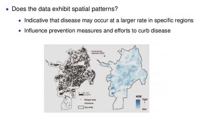
Combining Geodata and Machine Learning
A study published by a team in Boston Children’s Hospital used several data sources and machine learning to pinpoint influenza trends in the United States. They trained their algorithm with data on the weekly total visit count of hospitals and visit count for flu and flu-like illness, and gave a finishing touch with visit count of flu vaccination between 2009 and 2012.
Using geospatial data and machine learning has proved its effectiveness for creating more accurate predictions and relations between different information
As these models become even more complex and accurate, we should be able to utilize data even better in decision-making. Building hospitals in optimal locations, and pouring more resources into areas where the risk of viral infections is higher, might be worth considering.

Value staying current with geomatics?
Stay on the map with our expertly curated newsletters.
We provide educational insights, industry updates, and inspiring stories to help you learn, grow, and reach your full potential in your field. Don't miss out - subscribe today and ensure you're always informed, educated, and inspired.
Choose your newsletter(s)


