How Digital Twins Can Help Design Cities of the Future
As cities grow, communities' needs change. From traffic patterns and air quality to green space and other comfortable open spaces, urban planners have much to consider when deciding how to reshape a city’s landscape. Recently, researchers at the High-Performance Computing Center Stuttgart (HLRS) partnered with investigators at the Fraunhofer Institute for Industrial Engineering (Fraunhofer IAO) and local authorities from the German city of Herrenberg to develop a comprehensive model of the city.
Citizen participation in urban planning decisions – a key component in ensuring that urban planning decisions are benefitting those who live and work in cities on a daily basis – is often limited to occasional public forums, and municipal authorities must base decisions on limited datasets incapable of capturing all the complexities of daily urban life.
The project to create a digital twin of the city of Herrenberg can serve of an example for many other cities. Done in the framework of the “Reallabor Stadt: Quartiere 4.0” project, the first-of-its-kind model of a European city improved dialogue among politicians, planners, and the public at large, and helped create a roadmap for ensuring that plans for changing the urban landscape of Herrenberg are as detailed, complete, and equitable as possible.
Innovative computational tools and techniques
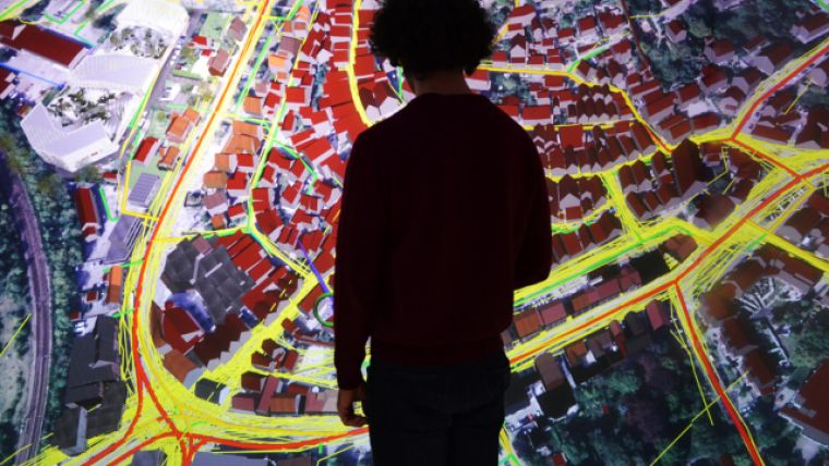
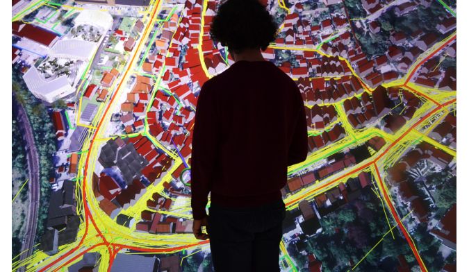
Combining radically different datasets into a cohesive, informative visualization required a suite of novel computational tools and techniques. The team focused on creating a “digital twin” of the city; that is, a hyper-realistic computational model. Originally developed for engineering applications and product development, HLRS staff wanted to apply the approach to urban planning – a significantly harder challenge.
“A city functions like a machine in many technical areas – the power grid and the traffic flow, for instance – but it is much harder to measure the social aspects,” said Fabian Dembski, researcher at HLRS and collaborator on the project. “Our goals were to integrate socioeconomic data from communities that are usually underrepresented in these discussions and to present a more complete picture by integrating multiple datasets to support decision making in urban planning.”
Virtual reality environment
To include social data in the model, HLRS staffers participated in outreach activities to inform Herrenberg residents about the technology and to encourage them to submit data about their community. The visualization team built collaborative virtual reality (VR) environments at several events around the city, encouraging the public to explore their city digitally.
In addition, the team presented the project during a local youth congress to encourage young adults from the city to download the “Reallabor Tracker” app on their smart phones. The app was designed as a “volunteered geographic information” application, encouraging users to submit how they feel in certain locations or whether they regularly see heavy traffic congestion or pollution in a particular area.
Spatial network analysis
When the digital twin was finally unveiled, it included 3D city imaging data, wind flow data, urban mobility and movement pattern simulations, and traffic flow simulations, as well as the qualitative data received from the app. The team also included a “spatial network analysis,” which includes both qualitative and quantitative data of a city’s urban grid. Specifically, the team focused on data points such as how enjoyable pedestrians found a particular street in relation to the rest of the city or the frequency at which pedestrians use particular paths or streets.
The team plans to continue the project with Herrenberg while also looking for opportunities to expand the model's level of detail and to apply it to other urban spaces. Moving forward, it would like to integrate more information on different grids – electrical and heating grids, for instance – and apply machine learning techniques to create more realistic simulations of movement patterns, air quality, traffic, and building design, as well as socioeconomic datasets such as demographic data.
“Just like cities, this model is never truly ‘finished’,” Dembski said. “Urban spaces are always changing, and we want our model to function in a similar way – I think this type of approach is valuable for cities, urban planning, and our computational work.”
This article was contributed by the High-Performance Computing Center Stuttgart (HLRS).

Value staying current with geomatics?
Stay on the map with our expertly curated newsletters.
We provide educational insights, industry updates, and inspiring stories to help you learn, grow, and reach your full potential in your field. Don't miss out - subscribe today and ensure you're always informed, educated, and inspired.
Choose your newsletter(s)


