How Machine Learning Makes Cadastral Mapping Faster and Cheaper
Estimates show that nearly 75% of the world's population still do not have access to formally accepted land registration systems. According to University of Twente PhD student Sophie Crommelinck, cadastral mapping can be automated using an intelligent and interactive computer program she developed and described in her thesis. As a result, parcel delimitation takes 38% less time.
A large part of the world does not yet have reliable land registration systems, including several East African countries. The lack of cadastrally registered land rights leads to uncertainty about land ownership and sometimes to life-threatening conflicts. Documenting borders is often the most expensive part of a land administration system. "You need a lot of technically trained manpower to perform cadastral measurements, but also expensive technologies to measure the borders," says Crommelinck.
Recognizing physical land borders
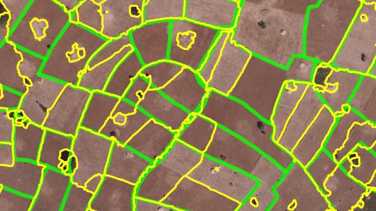
In her dissertation, Crommelinck describes a computer program that uses the same techniques as facial recognition software. She uses these techniques to recognize physical land borders on satellite, aerial and drone photography. "This system can be applied in areas where boundaries are defined by physical objects such as fences, walls, hedges, roads, buildings or rivers. The objects must be visible and there must be a need for cheaper land administration approaches, as is often the case in Kenya, Rwanda and Ethiopia," says Crommelinck. Using machine learning, the program ‘learns’ which objects in the photos are likely to indicate land borders.
Ultimately, her research leads to a process in which one person indicates the definitive boundaries in an interactive program. First, the program calculates the most probable land borders, after which someone with knowledge of the area selects the right plots. The system was tested on satellite, aerial and drone photos of parcels spread over Ethiopia, Rwanda and Kenya. "We show that our approach is less labour-intensive and more efficient than manual demarcation," says Crommelinck. Not only does it require 38% less time, but it also requires 80% less clicking per plot.
Its4land
Crommelinck's research is part of the EU project its4land. Its4land develops innovative applications for land registration. The Faculty of ITC (Geo-informatics Sciences and Earth Observations) of the UT is the leading partner of this project. More information and a short animation about its4land can be found on the website.
For more details, you can also read Sophie Crommelinck's article 'Towards Cadastral Intelligence?', published on our website and in the May/June 2019 issue of GIM International.

Value staying current with geomatics?
Stay on the map with our expertly curated newsletters.
We provide educational insights, industry updates, and inspiring stories to help you learn, grow, and reach your full potential in your field. Don't miss out - subscribe today and ensure you're always informed, educated, and inspired.
Choose your newsletter(s)


