How YellowScan is Pioneering in the World of UAVs and Lidar
Crossing the Ocean Marks New Milestone in Company’s Advance
YellowScan is one of the most eye-catching companies in the world of unmanned aerial vehicles (UAVs) and Lidar. From its beginnings as a small start-up created by professional surveyors with the goal to revolutionise the market, YellowScan has since become an established name thanks to a passionate team keen to deliver the best Lidar solutions that enable customers to achieve the best results from their projects. The French company has now decided to broaden its horizons by opening an office in North America. This article provides insight into YellowScan’s continuing journey towards making UAVs and Lidar a mainstream solution for mapping and surveying jobs.
(This article is brought to you by YellowScan)
It all started in Montferrier-sur-Lez, a small town in the southeast of France, in 2012 when a group of surveyors decided to create their first Lidar system. The prototype was such a success that they set up a company as a spin-off of L’Avion Jaune, a service-based company providing high-definition aerial imagery. From there, the first Mapper was born - a turnkey Lidar system for under-vegetation 3D modelling. A complete product range has been created since then.
A Team Beyond the Lidar Solutions
YellowScan started with a team of four but over the years this has increased to a crew of 30 highly dedicated experts in their own disciplines, with the company’s determination to continuously improve products driving this exciting growth. With a huge investment in R&D, YellowScan designs, develops and produces all of its Lidar systems for UAVs. By constantly improving the technical specifications and the ease of use of its systems, the passionate team aims to make it possible for surveyors to fly drones longer and higher, to access remote rugged terrains and to acquire meaningful accurate data.

Just Press the Yellow Button
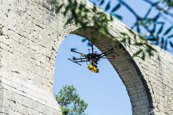
All the YellowScan Lidar instruments are built in line with the same vision: ‘Just Press the Yellow Button’. The user-friendly element is regarded as a key pillar underpinning the successful roll-out of the company’s UAV-Lidar solutions. The fully integrated systems include a laser scanner, IMU, GPS, embedded computer, storage and battery. They are designed to be easy to use, robust and reliable in order to provide surveyors, civil engineers, archaeologists and environmental scientists with a turnkey solution that can be mounted on any drone to meet their short-time data processing needs. All the systems are delivered with a software package including POSPac UAV (for trajectory post-processing) and YellowScan’s own processing software (to generate geo-referenced LAS point clouds in the desired projection).
For the IMU, YellowScan works together with Applanix. The integrated GNSS-inertial OEM solutions combined with YellowScan software are designed to improve the productivity of Lidar acquisition by eliminating ground control points (GCPs) and streamlining the data processing.
The newest systems, the Surveyor Ultra (the high-density and long-range Lidar system) and YellowScan Vx (the high-precision and long-range Lidar system) complete the ‘Just Press the Yellow Button’ product line. The successful YellowScan Surveyor is the world’s lightest fully integrated Lidar for UAV, and the Mapper II is the upgrade of YellowScan’s first Lidar system. LiveStation, the real-time in-flight Lidar monitoring kit (software and radio modems), complements this series.
Welcome to the USA
To support this growth, YellowScan is expanding its presence in the United States with the opening of a new office in Salt Lake City, Utah. The expansion will allow YellowScan to continuously serve its growing list of customers within the USA and Canada with first-hand local and tailor-made services for this market.
To gain an extensive update, three of the company’s experts talk about YellowScan’s activities and its Lidar solutions: Pierre d’Hauteville (PdH) who is head of sales and marketing at YellowScan, general manager Cliff Holle (CH) who – bringing over 20 years of experience and tactical know-how of the North American market – is set to head operations at the US branch, and Thibaud Capra (TC) who is an application engineer at the company. Here, they answer questions that reveal the company’s DNA, its expansion plans in the North American market and the multitude of possibilities that the UAV-Lidar combination offers to give us a glimpse of the future.
YellowScan was founded in 2012 and has enjoyed significant growth since then. What are the main pillars of your success?
PdH: When it comes to building a successful business, you should focus on a powerful team of people, a rewarding customer experience and a strong relationship with your stakeholders. YellowScan has a team-based culture with an entrepreneurial spirit at all levels. We give our employees the opportunity to succeed and to play a full part in our success story. We are a team of 30 talented people (and growing) who are passionate about what they are doing across the world. The field experience of most YellowScan team members and hundreds of projects done since our creation mean that YellowScan is a trustworthy brand created by surveyors. We provide an outstanding customer experience because we know and understand our end users’ needs. We support them by giving them the right product to achieve the best results in their projects. The ‘Just Press the Yellow Button’ product line was born following the same vision, offering robust, reliable and user-friendly YellowScan Lidar solutions. To support this growth, we created strong relationships with our stakeholders. From our suppliers to our distributors, we have created a relationship of trust. We are working with the best vendors because we want the best quality in our Lidar. Our distributors are working with us because we provide a high-end product and they quickly get a return on their investment.
Your mission is to help lead the Lidar revolution in remote sensing and GIS 3D mapping. How does that revolution look?
PdH: This revolution looks very promising. People’s perception about UAV technology is changing. We are moving to a better acceptance of UAVs flying in civil areas or beyond line of sight. This revolution may lead to more flexibility in the UAV regulations and, as a result, an increase in the number of projects done with UAVs. The customer tends to be more demanding in terms of quality and productivity to deliver an increasing number of UAV-based projects. To meet the market needs, each year we are working to develop new systems, streamline acquisition and processing workflows or provide services to satisfy the end user’s requirements.
YellowScan offers complete solutions, covering the whole workflow. How user-friendly is the complete package, i.e. capturing, processing and visualising the data?
PdH: Our vision can be summed up in one sentence: ‘Just Press the Yellow Button’. At YellowScan we aim to always develop products that are as user-friendly as possible to make our end users focus only on their use cases. From capturing to delivering, it can all be done in one day. We have many R&D projects in progress to be closer to the field needs and to make all our Lidar easy to use. As an example, YellowScan LiveStation provides system operators with the immediate and relevant information needed to ensure smooth acquisition even in difficult working conditions. It renders a real-time, three-dimensional representation of the point cloud during flight. Simultaneously, the user interface presents an immediate summary of the system’s status. And missions can later be replayed for analysing flight conditions and data.
Over recent years, YellowScan has been developing a growing number of UAS-Lidar products. How would you describe your current product range?
PdH: Each of our systems has different characteristics that can meet a wide range of demands. From research to civil engineering and from forestry to urban mapping, we can support our clients who require fast and detailed 3D terrain mapping, even under canopy. For instance, the new Vx-20, with an accuracy of 2.5cm, is perfect for city planning and infrastructure development where the absolute accuracy really matters. Surveyor Ultra, with its long range and lightweight, can fly safely aboard fixed-wings and VTOLs to map corridors and forests.
YellowScan has been working with the philosophy that our products should be able to be integrated on any platform in just a few minutes. And because they are fully autonomous and turnkey, pilots feel safe and Lidar operators are confident they can collect the reliable data they need to their customer’s satisfaction.
YellowScan is broadening its horizons and opening a new subsidiary in the United States. What made you decide to expand your activities there? And what are your plans?
CH: Currently, a very large portion of the enquiries we receive are coming from the North American region. We are developing our sales partnerships in this region but, to provide the partners and our end users with the very best service and responsiveness, we decided that it was necessary to open a US office.
How can mapping and surveying professionals in the US (and Canada) expect to benefit from your presence?
CH: By bringing a physical YellowScan presence to this region, we can offer training, sales and technical support to the mapping community. We can do this during US working hours and be much more responsive this way.
How is the demand for UAS-Lidar solutions evolving there, and how does that compare with the trend in Europe?
TC: The US market is very demanding, and it has been continually growing ever since the beginning. It’s going to be a great challenge. The trend is about the same in Europe, but I would say things move faster here in the United States, mostly because of the recent talks on and evolution of beyond visual line of sight (BVLOS) flights that are mandatory for certain applications if you’re after productivity – and, in the end, that’s the name of the game.
What are the main application areas for UAS-Lidar mapping? And which categories of customers are you targeting?
TC: Applications vary on a large spectrum, but the main ones would be mapping, corridor surveys, mining, civil engineering and forestry. I would not say that we specifically target a particular type of customer, but more that we provide solutions fitting a given customer profile. For instance, the YellowScan Surveyor Ultra is a perfect fit for fixed-wing operations, bringing a very efficient solution to anyone having to cover large areas. I’m mostly thinking about the corridor mapping industry in this case. Another example would be the YellowScan Vx providing great accuracy and precision to clients that are after it, such as civil engineering companies. The Vx-20 is equipped with an APX-20 too, allowing high-accuracy work with very little post-processing required.
Aerial mapping professionals can choose between photogrammetry and Lidar. For which tasks is Lidar the most appropriate solution?
TC: The big difference between photogrammetry and Lidar is that a Lidar is an active sensor. This makes it possible to penetrate vegetation and accurately describe the ground surface, whereas photogrammetry struggles to do so. All in all, I would say that any professional working with elevated features (vegetated areas, powerlines, buildings...) should turn to Lidar, which is now made easy to process; the path to obtaining a point cloud is not as challenging as it used to be! You can also combine our units with up to two cameras to colourise the point clouds and still have photogrammetric information and outputs if you need to. In my opinion, one of the best applications for Lidar is power-line surveying. Not only does Lidar give you information on the line, it also facilitates the work concerning vegetation encroachment by being able to measure larger swaths, thus increasing productivity too. Another great application is landslides, subsidence monitoring and crisis monitoring. Given the rapid deployment and the fast processing of Lidar data, one can monitor risky areas easily, even with vegetation coverage. Numerous software solutions are able to run a time-based comparison and provide results in no time, hence improving responsiveness in case of an emergency.

Value staying current with geomatics?
Stay on the map with our expertly curated newsletters.
We provide educational insights, industry updates, and inspiring stories to help you learn, grow, and reach your full potential in your field. Don't miss out - subscribe today and ensure you're always informed, educated, and inspired.
Choose your newsletter(s)


