Hydrographic Airborne Scanner Integrated in UAS
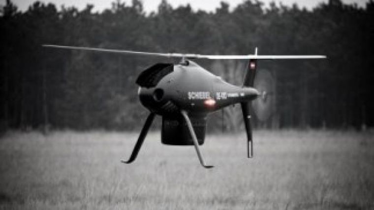
Schiebel and RIEGL, Austria, have successfully integrated the CAMCOPTER S-100 unmanned air system with the VQ-820-GU hydrographic airborne sensor. The integration marked the first time that the new airborne sensor had flown onboard a UAS.
The S-100 helicopter UAS carried a special Schiebel-made composite pod, containing the sensor, the IMU-GNSS unit, the data recording and transfer unit as well as a digital camera, during the flight tests in Grossmittel, Austria, which were carried out in December 2012. This fully integrated system thus enables acquisition of high-accuracy hydrographic and topographic data, even in critical operational areas.
The RIEGL VQ-820-GU is specifically designed to survey sea beds, the grounds of rivers or lakes and is well suited for combined land and hydrographic airborne survey. Fields of application include mapping of coastal lines, lakesides and river banks as well as mapping of archaeology and cultural heritage.
These fields of applications require repetitive surveying of inshore waters and are usually carried out by manned helicopters. The advantage of using the unmanned CAMCOPTER S-100 UAS over manned helicopters are that the system is uniquely capable of penetrating areas that may be too dangerous for piloted aircraft or ground patrols. This can provide additional safety and security for its users. Constant real-time information is acquired 24 hours per day without any need for prepared area and launch and/or recovery support equipment, due to the integrated system’s powerful surveillance capabilities. This drone system operates day and night, under adverse weather conditions, with a beyond line-of-sight capability of up to 200km, both on land and at sea. The S-100 UAS is also far more cost-effective than any manned alternative.
These clear advantages and complete integration of the RIEGL VQ-820-GU and the Schiebel CAMCOPTER S-100 UAS provides a new and innovative solution for airborne scanning to be done with unmanned aerial vehicles.
Dr Johannes Riegl, RIEGL CEO, said he was proud to have succeeded with this first integration of the company's bathymetric laser scanner with the Schiebel UAV. This high-end solution proves again RIEGL’s strive for excellence with delivering outstanding, market-leading solutions, he continued.
Hans Georg Schiebel, Schiebel Industries director, commented that the combination of this powerful and precise laser scanner with the S-100 allows swift and accurate mapping of remote areas and will prove valuable in applications such as mining, exploration and construction.

Value staying current with geomatics?
Stay on the map with our expertly curated newsletters.
We provide educational insights, industry updates, and inspiring stories to help you learn, grow, and reach your full potential in your field. Don't miss out - subscribe today and ensure you're always informed, educated, and inspired.
Choose your newsletter(s)


