Incident Command GIS System for Fire Department
Supergeo has helped the Taipei City Fire Department to develop a GIS system to ensure greater spatial data integration and distribution for effective fire prevention, disaster relief, and emergency rescue/emergency care.
The advances in technology increase more capability for firemen to protect life and property in our life. As the country's first Level-1 fire authority established by a local government, the Taipei City Fire Department contains five divisions which are responsible for the effective implementation of fire prevention, disaster relief, and emergency rescue/ emergency care.
To improve the response of disaster rescue and stimulate the integration of disaster rescue information of districts, the agency developed a Server-based GIS system to provide commanders and emergency personnel with dynamic data to effectively respond to events and conduct rescue command tasks such as preparation of disaster rescue information, tactics deployment, and safety management.
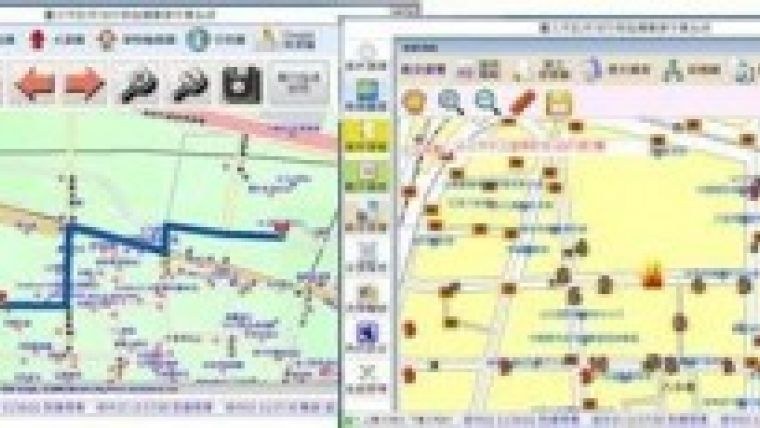
In an effort to satisfy the disaster rescue requirements of diverse map display, the Incident Command GIS System integrates and publishes various types of spatial data and offers front-end applications using SuperGIS technologies to assist emergency personnel in viewing and querying maps and transmitting integrated information of each district in Taipei. Consequently, commanders can obtain real-time disaster information to make prompt decisions for future rescue operations.
GIS allows the agency to build an information system for providing and integrating disaster rescue data of emergency dispatch management, rescue timing and sequence management for consequence rescue deployment. Rescue commander and personnel are also allowed to log in the system to identify the disaster location and distribution of nearby rescue resources to map out evacuation routes of rescue stands where emergencies occur.
In this project, SuperGIS Server enables access of dynamic spatial data and GIS functions that can be applied as GIS services in desktop, mobile and web applications over the Internet. SuperObjects provides COM framework development objects that can be directly embedded in programming language of Windows development environment for creating custom GIS applications to improve the agency’s operation.
In addition to performing the basic GIS functionality including data fusion, query, and map display functions such as zoom in/out, pan, basemap switch, printing, and online editing, the System enables account management, disaster data management, rescue timing management, offering the capability to create, manage, integrate and distribute GIS services.
With the Incident Command GIS System, both the commanders and the safety personnel can obtain the live information they need to deliver appropriate fire services and reduce the impact of unavoidable events.

Value staying current with geomatics?
Stay on the map with our expertly curated newsletters.
We provide educational insights, industry updates, and inspiring stories to help you learn, grow, and reach your full potential in your field. Don't miss out - subscribe today and ensure you're always informed, educated, and inspired.
Choose your newsletter(s)


