Increasing Climate Literacy
Climate Change and the Cadastral Surveyor
Climate change is said to have numerous impacts on land or, more generally, the environment. It consequently also affects property rights and boundaries, and climate change induced by boundary changes will increasingly pose a challenge to cadastral surveyors. Referring mainly to land administration practice in Australia, the author identifies five topics – drought, sea-level rise, natural disaster, sustainability and carbon trading – in which the cadastral surveyor is already involved or could play a future prevalent role.
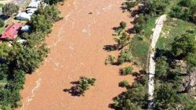
Drought shrinks riverbeds, forces governments to invest in water infrastructure, and requires innovative water governance and management. River boundaries are common in rural areas, with the property boundary generally extending to the riverbank or middle of the river, defined as midway between banks. In New South Wales (NSW) the ‘bank’ is defined as the limit of the ‘bed’; that is, ‘the whole of the soil of any lake or river […] which is adequate to contain the lake or river at its average or mean stage’. Determination of averages or means requires observations over time. What is the proper time span? River boundaries move due to erosion and accretion; can boundaries also move due to prolonged drought, possibly resulting in ‘permanent’ reduction to a riverbed? Hallman notes that in the State of Alabama versus the State of Georgia case, a riverbed is defined as ‘its average and mean stage during the entire year.’ Willis mentions a case, Kingdom versus The Hutt River Board (1905) 25 N.Z.L.R 145, in which reference is made to extreme events happening once in every two or three years. To take the illustration to the extreme, consider the recently flooded Castlereagh River in western NSW, (Figures 1); the State Emergency Services describes the riverbed thus: ‘Normally the river here has a dry, sandy bed’ (website 1). Does ‘normally’ suggest average or mean stage, and is the riverbed accordingly a legal entity? Such definitions increasingly require the attention of surveyors, especially where riverbanks are vaguely defined. Authorities may prefer to define a river boundary more explicitly than await court decisions.
Loss and Gain
Sea-level rise results in properties ‘moving’ closer to beach and sea, and/or becoming inundated (Figures 2 left and right/below). When planning urban sprawl governments apply added restrictions to protect property and manage infrastructure, often affecting the cadastre. Since the seabed is considered Crown land, legislation should resolve these issues. Under the Australian Torrens Title system straight-line boundaries are considered indefeasible, and recent court decisions brought no clarification (Figure 3, in next paragraph). Legislation has also been called for to enable acquisition of property when boundaries ‘encroach’ on the beach, thus limiting public access. Determining whether erosion and accretion is a natural event, or due to manmade defences against it, may complicate boundary determination. Flushman and Frank suggest that laws defining the littoral boundaries of land have been ‘adopted based on long experience with physical regimes that were stable over the long term and tended toward an equilibrium; what was gained over time could also be lost over time’. They further suggest that ‘climate change challenges the basic assumption on which our traditional boundary rules have been based’.
Natural Disaster
Natural disasters, including bushfire, tsunami, flood and land slip, involve destruction of or damage to the cadastral infrastructure; this means its re-establishment, with accompanying redetermination of boundaries. Movement of cadastral boundaries may indicate land movement due, for example, to storms after a long period of drought. Land movement may limit its development potential. Surveyors may thus be called on to investigate suspected potential land-slip areas.
Sustainability
Sustainability, the new ‘buzzword’ with respect to land development, impacts property values, and so features of sustainability often associated with property rights and boundaries need protecting. There is an increasing need to accurately measure, map and report on sustainability issues associated with the cadastre. Whilst restrictions may not be recorded on a title, it will be legislation which imposes restrictions on the use of property. Owners need to be aware of these restrictions as they apply both to their own and neighbouring properties. Surveyors with the ability to measure and map restriction issues are well placed to contribute to ‘Due Diligence’ reports when property transactions are undertaken. Floor area is an important measure for quantifying sustainability building ratings, and surveyors are tasked with determining these and identifying inclusions and exclusions. Surveyors should involve themselves in advising on legislation amendments, clarifying the numerous floor area measurements used not only for sustainability but also for leasing and town planning. A recent trend in Canberra is the development of affordable and energy-efficient homes on green-field estates, resulting in approval of terrace-type housing with party walls on very small land parcels. The Australian Capital Territory land administration system does not allow for variation from the approved boundaries, and requires registration of survey plans prior to building. This creates difficulties when developers need to ‘sell’ properties ‘off the plan’, prior to registration or construction. The construction of walls may not correspond with plan boundaries, resulting in encroachment. Building such dwellings may require adaptation of land-administration policies and procedures.
Carbon Trading
As governments increasingly commit themselves to reducing carbon emissions, property becomes a critical component of carbon trading. An Australian Property Institute policy paper states that land surveys will be critical to sequestration validation, as subsequent valuation of carbon property rights will be successful only in the presence of prior settlement of defined property rights. The paper continues: ‘The carbon property right will need to be defined in terms of not only location on the cadastre, but also fix the quantity of carbon and sequestration for the life of the property’. Surveyors have to be aware of the various methods of carbon sequestration, and may need to expand their expertise to meet measurement and documentation requirements. Surveying regulations may need to be increased or amended to cater for carbon trading requirements.
Concluding Remarks
Climate change and the resulting services required by society challenge the cadastral surveyor to increase skills in unfamiliar areas of surveying or business. In the words of McKeon, ‘the community will need to increase its ‘climate literacy’ so that political, social, economic and environmental decisions are better informed’.
This is a modified version of a paper presented at the FIG 2010 congress in Sydney in April 2010.

Value staying current with geomatics?
Stay on the map with our expertly curated newsletters.
We provide educational insights, industry updates, and inspiring stories to help you learn, grow, and reach your full potential in your field. Don't miss out - subscribe today and ensure you're always informed, educated, and inspired.
Choose your newsletter(s)


