Increasing the Accuracy of Mobile Mapping Positioning Using SLAM
Mobile mapping systems usually rely on GNSS observations to maintain high positioning accuracy. Meanwhile, it is often necessary to use these systems to map areas where GNSS observations are not available, such as in tunnels, forests or urban areas with high buildings. Thus there is considerable interest in finding alternative sources of positioning data. A master’s thesis on ‘Increasing the Accuracy of Positioning in Mobile Mapping Systems’ investigated how point clouds from laser scanning can be used to support positioning using simultaneous localisation and mapping (SLAM) technology. SLAM is the computational problem of finding a robot’s position in an unknown area while mapping the area at the same time.
Mobile mapping systems are used to map the surroundings while on the move. One example is laser scanning of roads while driving in normal traffic. Mobile mapping can make data capture both safer and more efficient compared to traditional land surveying. The product is often a point cloud from laser scanning. Point clouds can be very detailed and are a perfect tool for further investigations and mapping of the terrain.
The accuracy of the point cloud depends on accurate positioning of the laser scanners. Positioning is often done by GNSS/INS-aided navigation. Inertial navigation has high accuracy over short periods, but tends to drift over time. Support from GNSS observations reduces the problem of drift, and high accuracy can be achieved for longer periods of time.
Land surveying and matching of point clouds
Lower accuracy is an issue whenever there are longer periods of GNSS outage. This is often solved by additional points (‘known points’), captured by traditional land surveying. The point cloud from laser scanning can be ‘matched’ to fit the known points. Although matching can be done quite efficiently in software such as Terrasolid’s TerraMatch, for instance, the entire process of land surveying and matching of point clouds is quite time-consuming and work-intensive.
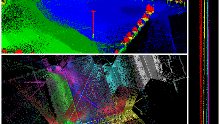
The point cloud from laser scanning can also be used to obtain observations of relative movement, based on scans of the same object at two different points in time. This can be done either by passing the same object multiple times or by scanners mounted so that the same object is scanned multiple times with a small time difference in between due to the vehicle’s motion.
SLAM can be used to take advantage of observations from the point cloud to support navigation. In the thesis, this approach was tested in post-processing using the TerraPos and TerraMatch software solutions, as well as additional software developed to integrate them. TerraMatch was used to automatically find relative point cloud observations. TerraPos is a navigation processing software with support for SLAM and was used to process navigation using relative point cloud observations to support the inertial navigation.
Point clouds observations in navigation processing
Tests done in the thesis showed that using point cloud observations in navigation processing can increase the accuracy of positioning in areas without GNSS observations, which in turn gives higher accuracy of the point cloud. This has the potential to reduce the need for additional land-surveyed points and can make the entire process of mapping by mobile systems less time-consuming and work-intensive. More testing is needed to evaluate the method for different terrain types and mobile mapping systems.
Using more of the data collected by the mobile mapping system can make the navigation processing more robust and make it possible to provide high accuracy in a wider range of terrain types. It is a matter of taking advantage of as many available sensors for navigation as possible.

Value staying current with geomatics?
Stay on the map with our expertly curated newsletters.
We provide educational insights, industry updates, and inspiring stories to help you learn, grow, and reach your full potential in your field. Don't miss out - subscribe today and ensure you're always informed, educated, and inspired.
Choose your newsletter(s)


