Indoor Positioning
Technologies, Features and Prospects
Outdoor positioning and navigation techniques using GNSS have been well explored and are now a vital part of daily life all over the planet. Since GNSS was initially designed to support the military during open-air combat, there was no need for the signals to be able to pass through walls and roofs. Indoor positioning therefore requires the alternatives to GNSS. How can geomatics contribute to the deployment of indoor positioning solutions? In aiming to find answers to that question, this article also examines current technologies and the various types of applications they originate from.
An indoor positioning system is a network of devices used to wirelessly locate objects or people inside a building or (partially) roofed venue. Indoor positioning (IP) may help an individual to navigate through a venue for leisure purposes or while making a delivery, service visit or emergency response (Figure 1). It may enable managers or authorities to wirelessly locate objects or people inside a building in a crowd-sourcing exercise. It may enable parents to track down their children while at a theme park. When scanning the wealth of R&D literature on IP, it is easy to get confused: the terminology, approaches, prospects and suchlike differ widely, ranging from the Location-Based Services (LBS) angle to a study of the dynamic behaviour of pedestrians as they move through roofed places. To bring some relief, I have arranged these angles in a chart (Figure 2); most of the subjects listed will be touched upon in this article, either briefly or in more detail.
Smartphones
Today, the term IP is closely linked to smartphones. In recent years, many tens of millions of these popular devices have been rolling off the assembly lines each year; as of mid-2013, iPhone and Android smartphones accounted for 90% of small-device purchases. Hundreds of millions of citizens, adults and children alike, in many of the world’s nations now carry such a device, and they have got used to its navigation and tracking facilities based on GNSS, GSM (cellular), Wi-Fi or Bluetooth signals. Outdoor positioning using a smartphone is even more reliable than regular car navigation systems; since the latter only explore GNSS signals – which may be weakened or blocked near high-rise buildings, under foliage or in tunnels – the result can sometimes be low-precision accuracy or even no positioning at all. However, the owner of an expensive Samsung Galaxy S4 may grumble, ‘Why does my device lose its navigation facility when I enter a shopping mall or an airport?’ to which the well-informed may respond, ‘GNSS works well outdoors but poorly indoors, since the signals emitted from satellites orbiting some 20,000km above your head are too weak to pass through brick and concrete.’ But the moaner may continue, ‘I want my handheld to work everywhere, anytime; that’s what I’ve paid for.’ Hence, Samsung, Nokia, Apple, Blackberry and other manufacturers are hastily working to embed IP solutions in their smartphones. Google, Microsoft and others are encouraging and supporting such efforts, since they sense opportunities for further expansion of their advertisement-based business models with huge gains up for grabs. And many researchers are helping them and publishing about IP.
Technologies
Various technologies have been explored for 2D or 3D positioning indoors. IP sensors can be grouped into two categories: autonomous systems which operate as stand-alone systems without any infrastructure support, and contingent systems which detect signals emitted by external devices or emit signals themselves. To the first group belong gyroscopes, accelerometers, magnetic field sensors and barometers. They can operate independently and are purposely miniaturised to fit small devices. As a result, they are sensitive to noise and hence inaccurate and prone to error when taking no precautions. Contingent sensors rely on wirelessly detecting signals – either electromagnetic or ultra-sonic – which are emitted by an infrastructure of transmitters. Most of today’s smartphones can trace GNSS, GSM, Wi-Fi and Bluetooth signals.
Basically, four components of a signal can be measured: phase, strength, angle and travel time. The latter is also called ‘time of flight’ or ‘time (difference) of arrival’ (T(D)oA), which delivers a distance (difference) using the speed of light or sound. This allows a position to be calculated through trilateration, which is a methodology equivalent to GNSS requiring at least three distances to be known. ToA, TDoA and Received Signal Strength (RSS) are all prevalent within IP, with RSS most widely used. RSS explores the relationship between the strength of a signal and the distance between transmitter and receiver. When the 3D positions of the transmitters are known, trilateration gives the position provided that the attenuation as a function of distance can be described mathematically (see the section on Fingerprinting) and reflections are modest. Most solutions are based on Wi-Fi signals as they are all around us, both indoors and outdoors (Figure 3). Nokia uses Bluetooth signals, which many systems can pick up, but their reach is a maximum of 10m and users have to switch on signal receipt –which few do since the power consumption is high and hence shortens battery life. ByteLight [1], a start-up based in Boston, USA, offers a method which resembles Morse code. By switching large numbers of ceiling-mounted LEDs on and off in high frequencies according to predefined patterns, each LED generates a unique code. When the phone’s camera captures the light pattern, it can be matched against the ones stored in a map database and thus used to identify the location. Australia-based Locata provides a GNSS lookalike consisting of a network of fixed, terrestrial transmitters which are placed at outdoor stations [2]. The signals are suited for IP as they can penetrate walls and ceilings. It provides a reliable and accurate solution but is definitely not a GNSS augmentation service, although it can be used in tandem with GNSS. The US Department of Defense relies on the system not only as a complement to GPS but also as a substitute when GPS becomes unavailable due to wilful disruption (Figure 4).
Maps and 3D Models
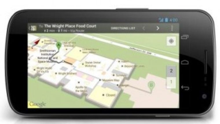
Navigation involves first of all positioning: the determination of 2D or 3D coordinates. But that is not enough. The position has to be linked to a navigable map of the floor plan or a 3D model of the interior of the building, both for providing clues on where the user is relative to the objects in the vicinity and for giving instructions on the best path to follow in order to reach the destination. One may start from scratch using photogrammetry, terrestrial laser scanning or other surveying methods, or by hand based on existing CAD drawings. The conversion of CAD drawings to IP-suitable maps involves many manual actions. Nokia’s team of over 1,000 surveyors created maps of more than 5,000 indoor venues in some 40 countries as a service to Microsoft. Google’s number of surveyed venues, which cover mainly the USA, amounts to over 10,000 (Figure 5). Apple is conducting similar activities. To ensure they get also a crumb of the cake, scores of smaller geomatics firms are specialising in indoor mapping both for mapping from scratch and updating – revisits are required on a regular basis due to changes in the layout of building interiors. Could crowdsourcing be an alternative mapping method? Shopkeepers and owners might upload a floor plan of their business venues and then map the positions of Wi-Fi access points. Google is running trials of maps created in this way but apparently without much success, since many business owners fear that Google will be the only one to benefit in the long run. In contrast to streets, where geodata can be collected freely or with just a handful of few permits or restrictions from authorities, hospitals and other indoor venues are usually privately owned. While owners of airports, shopping malls and universities are generally willing to allow mapping as a service to their visitors, the owners of buildings such as offices and hospitals may be reluctant to do so due to privacy issues.
Fingerprinting
The main method based on the weakening of a signal over distance has received the rather fancy term ‘fingerprinting’. Due to the presence of blockings, signal attenuation proceeds irregularly or even abruptly while signals are reflected, thus resulting in multi-path. As a result the relation between RSS and distance cannot be properly formulated in a mathematical way (Figure 6). The solution involves the creation of a dataset of signal strengths in addition to floor plans. In a training stage, the strengths are measured at sample points and stored in a database. In the location stage, when the IP device receives Wi-Fi, Bluetooth, audio or other signals, the strengths are compared to those at the sample points. The position can then be calculated from the coordinates of those points by choosing the nearest one or using all surrounding sample points and bi-linear or other advanced interpolation methods. The calculation is done either on the handheld itself or by a provider. In the latter case, someone else knows where the device and hence the user is, which may impair privacy. For those familiar with remotely sensed imagery, the grid map of the strength of the signals can be regarded as ‘ground truth’ which makes fingerprinting conceptually similar to multispectral classification using nearest neighbour, box, maximum likelihood or any other choice of the many methods available. IP using Wi-Fi has been the subject of in-depth research. Wi-Fi fingerprinting comes pre-installed on handhelds featuring Google's Android operating system and is likely to become a de facto IP standard. Fingerprinting without exploring Wi-Fi or other artificial signals has been launched by IndoorAtlas, a small start-up based in Finland [3]. Its method explores the natural signals of the Earth’s magnetic field which, in today’s buildings constructed from concrete and hence tons of steel, are ‘space varying’, i.e. the geomagnetic field will differ at every point. Sampling this field on a regular or irregular grid and combining this information with a digital floor plan enables positioning using the in-built magnetic field sensor (Figure 7). Combined with data from the built-in accelerometer and gyroscope, an accuracy of 3m has been reported. Since no infrastructure is needed it can be implemented at low cost.
People and Goods
Warehousing and logistics demand systems enabling 3D positioning of objects indoors. Tracking of rescue workers and victims has become vital during fire-fighting operations or in response to an earthquake. Furthermore, the location of patients in sprawling hospitals or of the elderly in nursing homes has become essential. Crowdsourcing to study the behaviour of groups has also become a vivid research area. It allows an understanding of why people follow the same routes over and over again and avoid certain areas. Such knowledge may improve the future design of buildings, which is paramount now that nearly four billion of the world’s population are living in urban areas. Store managers are likely to be eager to pilot initiatives for attracting potential buyers by automatically sending promotional notifications to consumers in or near to their shops. Such advertisements may also be highly customised as search engines store individual browsing behaviour.
In addition to Wi-Fi, radio frequency identification (RFID) enables the identification and tracking of machine components, vehicles, persons or livestock. RFID systems contain three parts: a transponder (RFID tag), a ‘reader’ consisting of antenna and transceiver, and a host computer. When the reader detects the RFID tag, the antenna emits a signal and starts transmitting data stored in the tag. Roofed areas of factories and warehouses often feature dedicated systems based on active RFID tags, which emit signals themselves, for managing and tracking goods (Figure 8). Active tags are bulkier and more expensive than passive tags and their lifespan is limited. Therefore, studies are being conducted on the use of passive RFID tags which are read-only. In recent decades buildings of huge dimensions, both in terms of height and horizontal extension, have been erected in rapidly expanding megacities such as Dubai, Guangzhou and Shanghai to name but a few. The management of such massive sites requires efficient tracking of concrete mixers, cranes, rebars, construction workers and many other resources.
In-Location Alliance
GNSS was developed by the central governments of the USA, Russia and China predominantly for military purposes or, in the case of Europe’s Galileo, to ensure independence from other nations if their governments ever switched off the service for civilian use. In contrast, the development of the IP infrastructure is in the hands of private companies, with obvious drawbacks including duplication of efforts, flat learning curves, wasting of money and – since the strongest will ultimately survive – monopolisation. In acknowledgement of this, 22 companies including Nokia, Samsung, Sony Mobile and Trimble Navigation joined forces to form the In-Location Alliance in August 2012 [4]. The collaboration aims to bring together innovation on IP technology and LBS. Esri joined in June 2013. By September 2013 the list counted over 100 members, many of which are geomatics research institutes or part of the geomatics industry.
Concluding Remarks
Outdoor positioning has become an unimaginable success, and indoor positioning is set to follow the same path since it is expanding very rapidly, both technologically and with respect to applications. This article has shown that the field of geomatics can play a pivotal, if not propulsive, role in further advancing this exciting R&D and business area.
Acknowledgement
Thanks are due to Edward Verbree for commenting on the final draft.
More Information
[2] www.locata.com
[4] www.in-location-alliance.com
Biography of the Author
Mathias Lemmens gained a PhD from Delft University of Technology, The Netherlands, where he presently lectures on geodata acquisition technologies and geodata quality on a part-time basis on the recently renewed geomatics MSc programme. He is the author of the book Geo-information: Technologies, Applications and the Environment published by Springer in 2011. He was editor-in-chief of GIM International for ten years and now contributes as senior editor.
E-mail: m.j.p.m.lemmens@tudelft.nl
Figure Captions
Figure 1, Example of personal navigation.
Figure 2, Diversity of angles from which the topic of indoor positioning can be approached.
Figure 3, Wi-Fi logos are now so ubiquitous that a candy maker announced a ‘Free No Wi-Fi Zone.’
Figure 4, A Locata beacon installed at White Sands Missile Range, USA.
Figure 5, Google map of the interior of the Space Museum, Washington, USA.
Figure 6, Received Signal Strength (RSS) from Wi-Fi access points: A weak, B medium, C strong.
Figure 7, Example of anomalies in the magnetic field of the Time Warner Center building, New York, USA, June 2012 (source: IndoorAtlas).
Figure 8, Indoor positioning used in an IKEA warehouse.

Value staying current with geomatics?
Stay on the map with our expertly curated newsletters.
We provide educational insights, industry updates, and inspiring stories to help you learn, grow, and reach your full potential in your field. Don't miss out - subscribe today and ensure you're always informed, educated, and inspired.
Choose your newsletter(s)


