Innovative Geospatial Technology in Burkina Faso
Burkina Faso has a population of 17.5 million and is one of the poorest countries in the world. During the colonial period and after independence, land was vested in the state and hence there was no legal recognition of customary land rights. Several years ago, the country recognised the adverse impact of the lack of land tenure security on promoting investment and consequently increasing production in the agricultural sector. New approaches in registration have since been developed with the support of modern technology.
(By William Marbell, United States, and Alain Bagre, Burkina Faso)
In 2008, the government of Burkina Faso entered into a compact with the Millennium Challenge Corporation (MCC) of the United States that aimed to reduce poverty through economic growth. When defining the objectives of the compact, a participatory country ownership approach was adopted to ensure that it addressed the needs considered by the government. In particular the compact seeks to improve rural land governance in order to enhance agricultural investment, improve access to markets by rehabilitating vital corridors of the road networks, and enhance rural agricultural production through irrigation and accessibility of improved extension services. The lack of legal foundation for the – predominant – customary tenure system for rural agricultural lands constitutes an inherent risk that deters the investment needed to produce the growth required to ameliorate the high incidence of abject poverty prevalent in the country.
Land Registration and Cadastre
Prior to implementation of the rural land governance project, the process of land registration was not decentralised to the provinces, which is where most of the poor, peasant farmers reside. That meant that any effort to register land potentially involved a considerable amount of travel to regional centres often distant from the farming communities and at a great expense. Any attempt to improve and streamline the process of registration of rural lands therefore needs to decentralise the registration process in order to make rural land administration more accessible to its intended beneficiaries.
A critical component of a functional land registration system is a cadastral plan that delineates the land that is to be registered. It captures the boundaries of registered land in terms of an unambiguous system of reference that supports demarcation of the boundaries of the registered parcels, should a boundary dispute arise.
Burkina Faso’s existing geodetic infrastructure is underpinned by a network of 54 primary control points based on the Clark 1880 ellipsoid and a UTM projection. Rampant disturbance and destruction of the control points within the network from the primary to tertiary level meant that producing cadastral maps tied to the national control network was an expensive enterprise. As a result of the sparse density of control points, the process involved extensive traversing with conventional optical instruments to long baselines requiring high-accuracy GNSS receivers and long occupation times using satellite positioning techniques. Hence most cadastral plans were tied to local coordinate systems, making it impracticable to create a homogenous record of all land transactions data using the existing spatial data. The rural land reforms envisaged under the MCA Burkina Faso rural land governance project include upgrading the existing geodetic infrastructure in order to reduce the cost and complexity of determining positioning.
The dawn of a new era
To facilitate the implementation of the land policy under the auspices of the MCA-Burkina Faso rural land governance project, a new law governing the administration of land was adopted and enacted in June 2009. This law permits the recognition of customary land rights through the issuance of rural land certificates. Traditionally, women in Burkina Faso tend to have a right to the use of communal land but do not qualify to legally own land, in spite of the fact that they are often active contributors in the sustenance agrarian system prevalent in the country’s rural communities. Under the new land law that has been promulgated, provision is made for the recognition of the rights of women to own land. This provides an mechanism to bridge the yawning gap between men and women in land ownership.
To bring the process of land administration to the doorstep of its target beneficiaries, rural land officers from the project communities have received training in the use of satellite-based positioning techniques and appropriate application software to create and deliver affordable land registration documentation, including cadastral maps, at significantly lower cost than what existed before the reforms.
In order to support the rural land registration programme and to update the existing land-governing technical standards for surveying work in tandem with recent developments in technology, a new technical standard for surveying work has been enacted into law (see Table 1).
|
The new national geodetic reference frame and plane coordinate system is defined by the following parameters: - Reference Ellipsoid ITRF 2008 ; - Ellipsoid IAG GRS80 (Semi Major Axes a = 6 378 137,00 and flattening 1/f = 298,257222101); - Map Projection BF-TM (Transverse Mercator) - Central Meridian 1° 30’W - Co-ordinates of Projection (X0 = 600 000,00 m, Y0 = 0,00 m) - Scale Factor: K0 = 0.9996 |
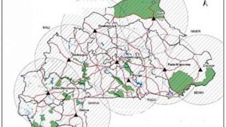
The process of determining the positioning that enables the work to be done by rural land registration officers with minimum academic qualifications (equivalent to a high-school diploma) is based on the simplicity and streamlined workflow that is made possible by the appropriate technology that underpins the new registration process. A network of nine continuously operating reference stations (CORS) covering the national territory as shown in Figure 1, in conjunction with handheld GPS receivers and application-specific software, provides a cost-effective procedure for providing affordable land documentation, including cadastral plans at the local level, using trained staff from the project communities. The nine-station network, built on Trimble’s proven technology, forms the foundation of the primary active geodetic infrastructure of Burkina Faso (see Figure 2). The network is scalable based on need into a fully fledged system that supports a continuum of accuracy in real time. The new geodetic infrastructure provides a foundation for producing cadastral plans within a unified coordinate reference system for effective and integrated management of land records.
Prior to the reforms, preparation of a cadastral plan necessitated the use of professional surveyors’ services since the state of the geodetic infrastructure required extensive technical expertise to determine positioning in conformity with the existing technical and legal requirements. The cost of creating cadastral plans as a result of the reforms and the use of technology has been drastically reduced from USD200 prior to the project to a nominal value of USD10 (government of Burkina Faso, 2012).
Starting to bear fruit
A total of 13,696 titles have so far been issued in three communities within the province of Ganzourgou as part of the rural land tilting component of the MCA Burkina Faso rural land governance project (see Figure 3). Under the new dispensation, community rural land registration offices submit registered rural land documentation to the regional office of the cadastral service for integration into a regional land information system that forms the basis of a national system. A total of 47 cadastral offices have been opened across the country to bring rural land registration to the doorstep of the rural population.
The GNSS CORS technology adopted makes it marginally cost effective to produce georeferenced cadastral plans in conformity with new technical regulations while providing a more efficient mechanism for the maintenance and management of the geodetic control system for other applications. The technical capacity of staff of the national mapping agency, the cadastral service, the new rural land registration centres and professionals in both the private and public sector who will benefit from the use of the new geodetic infrastructure has been enhanced through the extensive training modules delivered in the use of satellite-based positioning techniques offered under the scope of the project. In excess of 1,200 individuals from various organisations have subscribed for the CORS network data and services.
Concluding remarks
The rural land reforms are expected to facilitate an increase in investment in rural agriculture as a result of the reduction in the risk of tenure insecurity emanating from the recognition of customary rights guaranteed under the new land law and the associated reforms that are being pursued in the project intervention zones. The anticipated increase in investment in rural agriculture as a result of the land reforms will enhance the creation of wealth and reduction of rural poverty. The project in Burkina Faso has demonstrated that appropriate modern technology can be used to deliver affordable and sustainable land administration services to the often-marginalised rural poor.

Value staying current with geomatics?
Stay on the map with our expertly curated newsletters.
We provide educational insights, industry updates, and inspiring stories to help you learn, grow, and reach your full potential in your field. Don't miss out - subscribe today and ensure you're always informed, educated, and inspired.
Choose your newsletter(s)


