Land Administration Domain Model
Impact on Implementation of International Policies
An international group of land administration professionals initiated the development of a data model that facilitates the quick and efficient set-up of land registrations. Just as social issues benefit from proper land administration, land administration systems themselves benefit from proper data standards. The Land Administration (LA) standard has been available since 1 December 2012 as a formal International Standard, published as ISO 19152. This standard is expected to have an impact on the development of Land Administration Systems.
The International Standard for the Land Administration Domain serves the following goals:
- Establishment of a shared ontology implied by the model: The knowledge of the land administration domain is documented with a focus on data.
- Support of development of the application software for LA: The data model is the core here.
- Facilitation of cadastral data exchange with and from a distributed LAS: This can be between cadastres, land registries and municipalities and between countries in a federal state or between countries.
- Support of data quality management in LA: Use of standards contributes to the avoidance of inconsistencies between data maintained in different organisations because data duplication can be avoided as much as possible.
LADM Requirements
Main political objectives, such as poverty eradication, sustainable housing and agriculture, and strengthening the role of vulnerable groups (e.g. indigenous people and women), are in many ways related to access to land and to land-related opportunities. This implies as a requirement that the model should be able to present all possible relations between people and land: formal and informal tenure, customary tenures, etc.
The development of the LADM is based on user needs. Open markets and globalisation require a shared ontology allowing communication between involved persons within one country and between different countries. This is also strongly related to the acquisition of large tracts of land by international parties such as in Africa, for example. Proper (transparent) management of such transactions requires an overview of the existing situation and agreements with all involved parties.
Of course, existing ISO and other open standards should be followed, including the de facto standard Cadastre 2014 of the International Federation of Surveyors. This will be highlighted in the next edition of this series of articles on the LADM in GIM International.
A short description
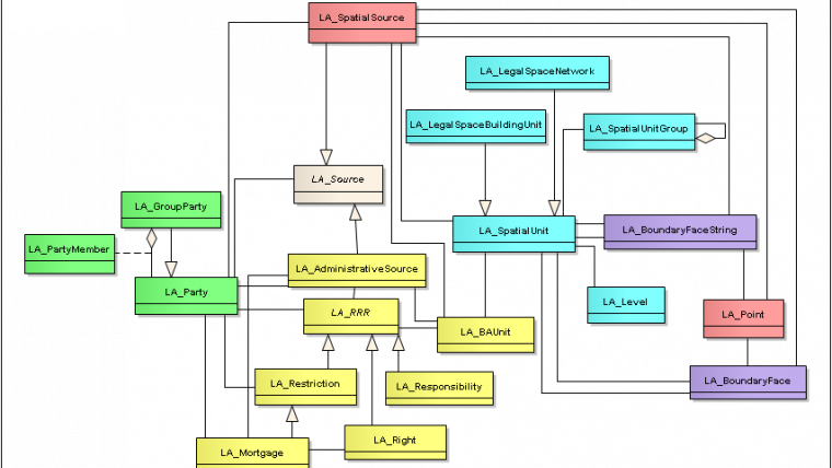
The model integrates essential data such as party names and rights with source documents such as titles, deeds, survey field data, court decisions, decisions made in participatory mapping and other decisions. All essential data can be related to authentic sources (e.g. documents or imagery with evidence from the field). Available ISO standards are re-used to support multimedia archives, measurements and observations as well as spatial representations. History is maintained and all attributes may have quality elements. This allows for proper combinations with workflow management which in itself is not included in the International Standard – except for issues such as role in the process (conveyors, surveyors) and relevant moments in applications (issuance data, acceptance date, etc). The LADM diagram is represented in Figure 1. A specialisation within the LADM is the Social Tenure Domain Model (STDM), which has been developed by UN-HABITAT, the International Federation of Surveyors and the University of Twente, Faculty ITC. STDM provides a land information management framework that integrates formal, informal and customary land systems. It has the power to tackle land administration needs in communities, such as people in informal settlements and customary areas. The emphasis is on social tenure relationships as embedded in the continuum of the land rights concept promoted by the Global Land Tool Network and by UN-HABITAT. Piloting STDM was presented in the first part of the LADM series in GIM International in the April 2013 edition.
The Continuum of Land Rights
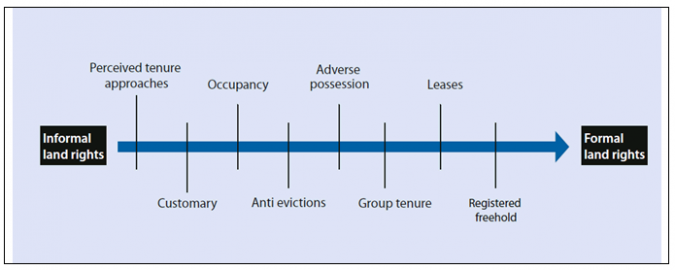
The continuum of land rights from UN-HABITAT deserves extra attention to understand the possible impact of the LADM and STDM. In the continuum, the various types of land rights are viewed as existing along a continuum, with some settlements being more consistent with law than others. This view makes it possible to include the people with the weakest tenures in the idea of sufficient legal access (Figure 2).
Spatial enablement is not primarily about accuracy; instead, it is about adequate identification, completeness and credibility. LASs (Land Administration Systems) should be built using a ‘fit-for-purpose’ approach, whereby accuracy can be incrementally improved over time when justifiably serving the needs of citizens and society. In relation to the concept of the continuum of land rights, such a fit-for-purpose approach can be seen as a ‘continuum of accuracy’. Where representations of spatial units are concerned, a continuum is introduced in the LADM: text-based, point, line-based, polygon-based or volume-based. This means support of approaches with and without topology, 2D, 3D and integrated 2D/3D. The same is valid for data acquisition on the administrative and spatial side: a wide range of options is available, and a range of pro-poor land-recording systems can be implemented. Again, a continuum of approaches is related. One more ‘continuum’ is on the subject side: there can be individuals, groups, groups of groups, communities and governmental organisations.
FAO’s Voluntary Guidelines
FAO’s Voluntary Guidelines on the Responsible Governance of Tenure of Land, Fisheries and Forests in the Context of National Food Security outline principles and practices that governments can refer to when making laws and administering land, fisheries and forests rights. This comprehensive set of guidelines includes ‘delivery of services’ and ‘records of tenure’ rights:
- National standards should be developed for the shared use of information, taking into account regional and international standards. States should strive to establish and maintain accessible inventories
- Where possible, states should ensure that the publicly held tenure rights are recorded together with tenure rights of indigenous peoples and other communities with customary tenure systems and the private sector in a single recording system, or are linked to them by a common framework. Systems should record, maintain and publicise tenure rights and duties, including who holds those rights and duties, and the parcels or holdings of land, fisheries or forests to which the rights and duties relate
- The spatial accuracy for parcels and other spatial units should be sufficient for their identification to meet local needs, with increased spatial accuracy being provided, if required, over time
- To facilitate the use of records of tenure rights, implementing agencies should link information on the rights, the holders of those rights, and the spatial units related to those rights. Records should be indexed by spatial units as well as by holders to allow competing or overlapping rights to be identified. As part of broader public information-sharing, records of tenure rights should be available to state agencies and local governments to help improve their services.
Impact
ISO standardisation is a comprehensive, extensive, formal process with continuous peer reviews and iterations based on experience of earlier implementations. For the LADM, this (creative) approach resulted in finding common denominators in land administration. The innovation is in the availability of the LADM as a basis for structuring and organising representations of people-to-land related information in databases in a generic way. This means that the LADM is one of the tools (or better: conditions) for the implementation of the continuum of land rights and for the FAO’s Voluntary Guidelines.
The wide range of functionality of the LADM is in support of:
- the continuum of land rights (management of different tenures in one environment), the continuum of approaches, the continuum of recordation, the continuum of spatial units and subjects. The LADM now opens up options for bridging gaps between cultures where people-to-land relationships are concerned, definitively not only in support of globalisation, but also with a strong focus on offering support in the protection of land rights (tenure certainty) for all
- land administration system design and development with coverage of all tenure types
- upgrading the quality of existing (and not properly maintained) datasets (consistency-building and validation)
- the management of a wide range of documentation. This concerns evidence from the field and legal, transactional and administrative documents
- the development of software and databases. Since developers like stable (but extensible) standards as a starting point for developments, both industrial software developers and open source software communities are enthusiastic. The LADM allows a flexible, step-by-step approach in the development of a Land Administration System based on the needs, priorities and requirements of users and society. This can be combined in a natural way with organisational development
- a link to workflow management. Processes are not integrated in the LADM; linking is possible by role types, versioning, quality labels and exchange of data between involved organisations
- structuring and organising data in interaction with data in other databases. The LADM can be used within a Spatial Data Infrastructure.
Strategic Choice
The standard has been designed in such a way that it can easily be changed depending on local demands. It is not about ‘dogmatic implementations’ with fixed rules; on the contrary, the approach is as flexible as possible. It is a common language for LA enabling various parties to understand each other. A choice for the LADM is a strategic choice in support of the latest insights and global views: the continuum of land rights and the FAO Voluntary Guidelines. ISO guarantees proper maintenance of the standard.
Final Remark
A LADM community is developing. The next LADM Workshop will be held in September 2013 in Malaysia (deadline for submitting abstracts is 31 May 2013 [http://isoladm.org/]). As editors are receiving more and more questions about application issues, the concept of LADM forms a basis for strategic development in land administration – let’s build the systems now to achieve wider goals.
Further Reading
- Augustinus, C., 2010. Social Tenure Domain Model: What It Can Mean for the Land Industry and the Poor, XXIV FIG International Congress 2010. Sydney, Australia.
- Enemark, S., 2012. Sustainable Land Governance: Spatially enabled, fit for purpose and supporting the global agenda. World Bank Conference on Land and Poverty, Washington DC, USA.
- FAO, 2012. Voluntary Guidelines on the Responsible Governance of Tenure of Land, Fisheries and Forests in the Context of National Food Security. FAO, Rome, Italy.
- ISO, 2012. Geographic Information – Land Administration Domain Model. Edition 1. Geneva, Switzerland.
- Lemmen, C.H.J., 2012. A Domain Model for Land Administration. Publications on Geodesy 72. Netherlands Geodetic Commission.
Websites:
http://wiki.tudelft.nl/bin/view/Research/%20ISO19152/WebHome
Biographies of the authors
Christiaan Lemmen holds a PhD in Land Administration from Delft University of Technology, The Netherlands. He is an assistant professor at ITC, University of Twente, and an international consultant at Kadaster International.
Peter van Oosterom received a PhD from Leiden University for his thesis ‘Reactive Data Structures for GIS’. He is professor at the Delft University of Technology (OTB institute) and head of the GIS Technology section.
Paul van der Molen holds a chair in Land Administration and Cadastre at the Faculty of Geo-information Science and Earth Observation at Twente University, Enschede, The Netherlands. He is the former director of Kadaster International.

Value staying current with geomatics?
Stay on the map with our expertly curated newsletters.
We provide educational insights, industry updates, and inspiring stories to help you learn, grow, and reach your full potential in your field. Don't miss out - subscribe today and ensure you're always informed, educated, and inspired.
Choose your newsletter(s)


