Laser scanning of damaged historical icons
Surveying technology is heading for maturity
How does the size of the site and the surveying aim affect the need for terrestrial laser scanning equipment? This article explains more, illustrated by four examples of projects to document historical buildings in 3D.
Terrestrial laser scanning is becoming an increasingly preferred surveying technique for the 3D documentation of historical buildings. 3D point clouds provide a wealth of information which advanced 3D mapping software can exploit in a relatively simple way, at least when compared to the tedious surveying techniques of the past. However, effective cooperation between architects and the survey team of experts is necessary in order to get the best out of this geodata acquisition technology. In this article, the authors first provide an overview of equipment based on the size of the site and the surveying aim, and subsequently give four examples of how terrestrial laser scanning can benefit the restoration of damaged historical buildings.
Throughout the ages, the preservation of iconic buildings has been a labour-intensive and expensive endeavour requiring the most advanced measuring techniques available at that time. Only buildings that were highly appreciated by rulers and citizens alike have survived the ravages of time, and such buildings usually fulfilled an important religious role in society: churches, cathedrals and temples, for example. In recent times, another type of building has been added to this list: industrial heritage. Today, terrestrial laser scanning (TLS) is one of the most advanced measurement techniques for the 3D documentation of such sites. The value of TLS for capturing damaged or decayed historic buildings is that scans can be used to accurately measure and virtually reposition partially or fully destroyed statues, ornaments and other elements. This provides insight into the damaged objects and into which elements can be restored and which will have to be completely remade.

Choice of equipment
The choice of specific surveying equipment depends on the size of the site and the aim of the survey. Scanning small or medium-sized sites requires one or more 3D laser scanners, with the setup dependent on size, budget and criticality. The instrumentation could include a laser scanner and/or scanning total station, tripods, batteries and data storage (USB key or SD card). For projects in which visual detail is important, an external high-end camera and panoramic head are recommended. Some laser scanners have a built-in camera with simple controls, and the image texture can be easily projected on the point cloud without cumbersome geometric transformations. However, an external high-end camera may be preferred for higher-quality imaging, although this requires more expert control. A necessity in the case of larger sites – and optional for smaller ones – are black and white markers, spheres and/or survey prisms in the overlap of scans for registration and georeferencing purposes. In addition, larger sites require the establishment of a network of ground control points (GCPs) using a total station or GNSS receiver. Continuous monitoring of building parts for deformation or subsidence requires prisms to be mounted on the relevant parts and multiple high-accuracy total stations to be permanently mounted on stable pillars. Combining the total station measurements in real time requires one or more controllers.
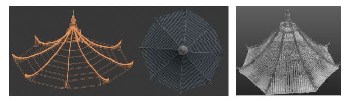
Scanning the Liuhe Pagoda
The Liuhe Pagoda (Six Harmonies Pagoda), located at the mouth of the Qiantang river in Hangzhou, Zhejiang province, China, has been demolished and rebuilt several times since originally being constructed in AD 970. Today it is a major tourist attraction (Figure 1). In addition to suffering human devastation, forces of nature have caused the monument to decay. Combined with the size of the pagoda, which is 13 storeys tall, this makes it a challenging restoration project. In 2013, its fourth major repair and renovation project began. The interior and exterior were scanned over a period of six months to support restoration. After scanning, which took three minutes per scan position, the building was modelled to find the missing parts, which required two to three hours per scan (Figure 2). Next the missing parts were designed, crafted by hand and assembled. For quality assurance and control inspections and detailed 3D documentation, the building was scanned using a compact 3D laser scanner resulting in 23 billion 3D points.
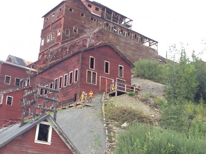
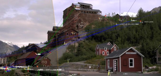
Mining heritage in Alaska
Kennecott Mines, Alaska, is a complex of abandoned copper mines and has been a US National Historic Landmark since 1987. The site’s iconic 14-storey building received raw ore delivered by aerial trams and delivered processed copper to railcars (Figure 3). To preserve the site after nearly 80 years of neglect, the site was placed under protection and mapped. In 2018, to improve detail and accuracy, the site was scanned during a three-day period using a Trimble SX10 scanning total station. The same instrument also measured individual points of key features of the building, such as roof and wall-corner points. The blue lines visible in Figure 4 show the traverses of the SX10 and the individual points. Ground control points were measured using Trimble R8 and R10 GNSS receivers; the base lines are shown in green. The traverse and GNSS measurements were combined with Trimble Business Center (TBC) software and registration and georeferencing was done with Trimble RealWorks.
Notre-Dame in Paris
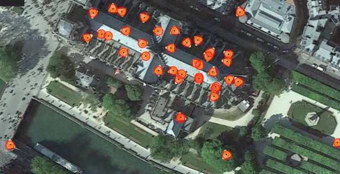
The construction of Notre-Dame Cathedral in Paris, France, started in 1160. Although it is today regarded as a world-famous example of Gothic architecture, by around 1830 Notre-Dame was in such a state of decline that demolition became a serious option. Notre-Dame Cathedral survived the demolition plans, thanks in part to various citizen initiatives to save the cathedral – including Victor Hugo’s novel Notre-Dame de Paris which was published in 1831 and later translated into English as The Hunchback of Notre-Dame. However, on 15 April 2019 a fire destroyed the spire, lead roof and oak frame of Notre-Dame. From the beginning it was clear that TLS would support restoration immensely. Although new TLS surveys allow accurate assessment of the damage, stability of the structure and required restoration works, they cannot provide information about the cathedral’s pre-fire stage. Fortunately, however, Prof Andrew Tallon – an architectural historian from Vassar College in the USA – had captured the entire cathedral using a Leica Geosystems TLS in 2010 (Figure 5). That accurate and detailed point cloud will be of tremendous help in obtaining a faithful reconstruction of Notre-Dame in its original state.
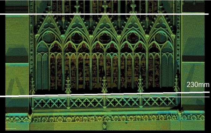
This illustrates the urgent need for accurate and detailed 3D models of cultural heritage sites, before disaster strikes or the natural elements erode their splendour. Detailed 3D reconstruction from dense TLS point clouds may also uncover construction details. For example, TLS revealed that the apparent skewness of the balcony of the south facade of Notre-Dame Cathedral in Amiens is not an optical illusion but is actually due to a 23cm height difference between the left and right sides which was caused by them being constructed independently (Figure 6).
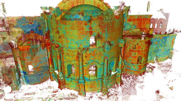
Church of Saint Simeon Stylites in Syria
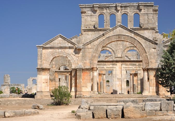
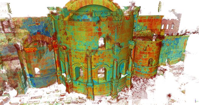
Another – albeit more remote – example of a demolished building that had luckily been scanned prior to hazard striking is the Church of Saint Simeon Stylites, Syria. The church dates back to the fifth century and was partly destroyed by a Russian rocket attack in 2016. Since 2003, the site had been regularly surveyed by crews from France, including by using laser scanning (Kurdy et al., 2011). One of the surveys was conducted with TLS equipment from the Ecole Nationale des Sciences Géographiques (ENSG) in 2004. The cruciform church (Figure 7) was captured from 36 positions using a Trimble TLS device with a horizontal field of view of 360o and a vertical field of view of 60o. In the overlaps of the scans, spheres were mounted for registration purposes. After manual removal of unnecessary points, the 250 million remaining points were processed to create 3D representations of relevant parts of the building. The resulting 3D documentation forms a historical record of the building and is very valuable in preparing and conducting the restoration work.
Terrestrial laser scanning: new business opportunities
TLS has come a long way since the late 1980s. Performance and productivity have greatly increased, while the cost of ownership, size and weight have decreased. TLS is not yet fully mature, however. Manufacturers still recommend a yearly calibration to maintain the specifications. Standard warranty periods are just one year, whereas two years is the norm for all other optical instruments. Once matured, TLS will be used much more broadly. Each innovation simplifies and speeds up the capture of 3D scanning data and eases the burden of expertise on geospatial professionals, thus opening up new business opportunities.
Further reading
Kurdy, M., Biscop, J-L., De Luca, L., Florenzano, M. (2011), 3D Virtual analysis and reconstruction of several buildings in the site of Saint-Simeon, Syria. Int. Archives of the Photogrammetry, Remote Sensing and Spatial Information Sciences, Volume XXXVIII-5/W16, pp. 45 - 52.

Value staying current with geomatics?
Stay on the map with our expertly curated newsletters.
We provide educational insights, industry updates, and inspiring stories to help you learn, grow, and reach your full potential in your field. Don't miss out - subscribe today and ensure you're always informed, educated, and inspired.
Choose your newsletter(s)


