
Enterprise operations adopting geospatial technology require high accuracy in their digital twins to make them a viable alternative to the real world for measurement and inspection. The challenge is to achieve accuracy with one simple, repeatable, scalable workflow across global assets at massive scale. MakeItAccurate makes very high accuracy simple, accessible and reliable, anywhere. According to the developers, this is an industry game-changer.
The need for high accuracy positioning has traditionally been the realm of surveyors and engineers. It’s what makes geospatial data valuable. New technology, such as drones, are now bringing geospatial to a broader range of sectors such as insurance, telco’s and utilities, for infrastructure asset management of cell towers, bridges, roads and buildings. The digital twins created by these new technologies enable tasks that would normally be done on-site to be handled remotely, enabling the experts to do their inspection, measurement and assessment from shared collaborative environments on their desktop computers.
Accuracy is essential in the data captured to make this digital copy a true representation of the real world and to make it useful over time. For instance, while an in-accurate digital model of a cell tower may have a lot of detail and enable one inspection, it will soon become less useful and less valuable on repeat surveys. When the tower is captured again, say a year later, the inspector will need to go to the exact locations of the original problems to see what has changed over time. Has the connector been replaced? Is that cable still damaged? Accuracy will bring him straight to the problem location.
Apply an AI product over this data to detect change and again it is only possible if the data captured is accurate.
These operations are often enterprise level, at great scale, aiming to capture virtual copies of tens of thousands of assets. The enormity of the task takes it beyond the scope of traditional survey and engineering practice. These projects demand simple, repeatable workflows, that are identical in any location and can be infinitely scaled; all with very high accuracy.
The same requirements can apply to mining, earthworks and engineering, where corporate operators are looking for reliable, repeatable, scalable ways to capture accurate representations of the ground, using data from UAVs, manned aircraft and mobile scanners. Deploying field crews to place control, running traditional base stations or sourcing network corrections data are costly, site-specific processes that hinder the ability to scale operations.
RTK
RTK has been the tool of choice for surveyors for a couple of decades now and was an early solution for drone data capture. Typically, radio links were the challenge with any breaks to that link causing loss of lock. GSM/NTRIP network connection systems improved this limitation, though range from base stations remain an issue.
PPK
In the past few years, PPK has become the standard for UAVs and manned aircraft capturing accurate data for photogrammetry or Lidar. A more robust solution than RTK, ensuring complete data from both base and rover, processed forward and backward, but still requiring base station data preferably within 30km. Users would run a local base or download CORS data (if available) from a variety of disconnected sources with varying reliability.
PPP
PPP (Precise Point Positioning) has been around since the 1990s as a way of increasing the autonomous (stand-alone) accuracy of GNSS. PPP uses precise global clock and orbit corrections, available either real-time via satellite (with a convergence time pre-mission) or weeks after in post-processing. The typical accuracy (0.1 - 0.5m) was not suitable for survey-grade work and there were some usability issues.
Klau Geomatics has now released a new hybrid PPK/PPP processing service
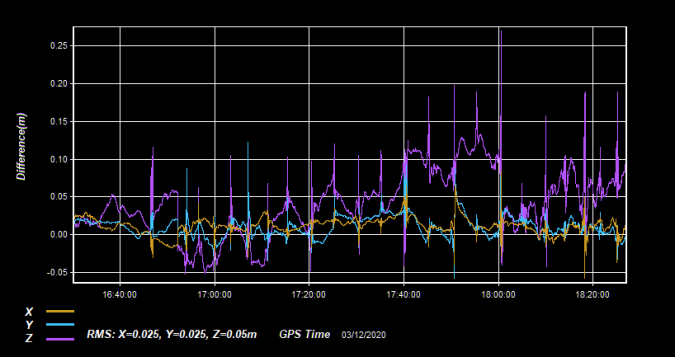
The latest PPP technology, core to the Klau Geomatics processing engine, enables highly accurate post-processing of full constellation GNSS data immediately after a mission. Achievable accuracy is 3-7cm anywhere in the world (see Figure1), and down to 2cm in many regions with the hybrid PPK/PPP algorithms.
The Klau Geomatics PPP processing engine accesses clock and ephemeris corrections from the satellite control stations, within 15 minutes of data capture. This results in highly accurate post-processed trajectories, anywhere, without base station data.
In many parts of the world, the KlauPPK processing engine applies sophisticated hybrid PPK/PPP algorithms, accessing up to 15 reliable CORS stations within 150km, to increase the achievable absolute accuracy to 2cm XYZ.
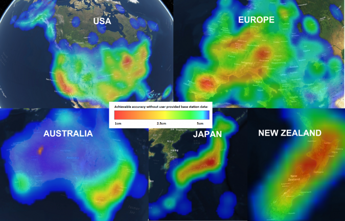
Plate Tectonics
PPP is very precise, and absolutely accurate relative to the global reference network. This is where it gets interesting as coordinates that we have always considered solid, are actually moving as the many tectonic plates we live on slide around in different directions over time.
The Klau Geomatics hybrid PPK/PPP engine models tectonic plate motion and accurately transforms coordinates for each region and country.
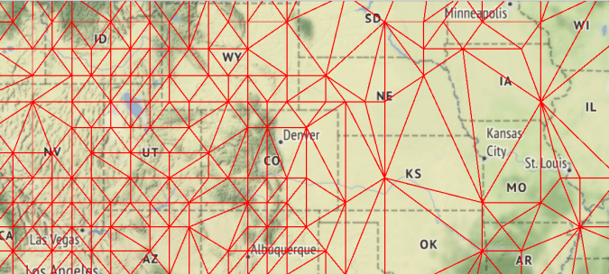
In the US, post-processed coordinates are accurately transformed using the modelled tectonic motion surface in three dimensions using over 500 ground stations provided by NGS (see Figure2). Final results are reported in both NAD83(2011) epoch 2010 and the current ITRF2014 datum.
In Europe, coordinates are converted to ETRF2014 (epoch 2010) using a 14 parameter datum transformation and station velocities. Japan uses the semi-dynamic tectonic plate for accurately transforming coordinates to the JGD2011 reference. GDA2020 and GDA94 are supported in Australia and in New Zealand NZGD2000 datum is used. Other parts of the world use the latest realization of the WGS84 datum for generating accurate coordinates.
MakeItAccurate
The MakeItAccurate hybrid PPK/PPP processing engine is accessible via an API, as integrated with the post-processing software for the KlauPPK direct georeferencing system. Aerial mapping companies (manned and UAV) using KlauPPK hardware can now add a PPP Near-Real-Time subscription for unlimited hybrid PPK/PPP post-processing, to achieve unprecedented accuracy, anywhere in the world.
Klau Geomatics has also opened access to the hybrid PPK/PPP processing engine for any other GNSS receiver via a Pay-Per-Use cloud processing service: makeitaccurate.com
While the best possible results are achieved with the custom-tuned KlauPPK hardware, MakeItAccurate is open to data from all other GNSS hardware manufacturers, preferably with full constellation data to get the best results. DJI RTK drones are supported, as well as data from many other drones using Septentrio, Trimble. NovAtel, Topcon, Ublox (Emlid), Leica Geosystems and others.
Static GNSS and kinematic trajectories for mobile mapping, surveying and exploration can also be processed. Pay Per Use, accessible for small drone jobs, scaled for larger missions.
Enterprise Focused
This solution enables enterprise drone operations to achieve very high accuracy across their entire global operations with one simple repeatable workflow.
The same process works for multiple operators on thousands of sites, even in the most remote regions. Every site is the same, without having to consider base station availability and reliability. One simple solution. Just fly your drone. Anywhere, remote areas, wide-area surveys… achieve consistent, very-high accuracy every time.
API Integration
A MakeItAccurate API is now available to push raw GNSS data to the processing engine and return highly accurate coordinates, with full reporting on the accuracy achieved for the entire trajectory or each camera event.
GNSS hardware manufacturers can offer a custom service to value add to their products. Software developers offering artificial intelligence technology, photogrammetry processing or any other outcome that benefits from high accuracy can use the MakeItAccurate API. SaaS platforms that offer photogrammetry processing and visualization can now offer a simple checkbox to “Make It Accurate”.
Contact Klau Geomatics for details of API integration.
IMU processing
Tightly coupled GNSS/IMU processing will soon be available to produce very accurate attitude and positioning information. A simple, seamless, base-station-free workflow for Lidar and mobile mapping. This service will be released soon. Contact Klau Geomatics if you’d like to run some data.
MakeItAccurate makes high accuracy simple and achievable. Accessible and reliable, anywhere. This is truly an industry game-changer.
Give it a try!
Each job is quoted before running, with a typical ground survey from US$15 to a drone mission cost of US$25. Your first few jobs are free, so we encourage you to give it a try and compare results with your usual methods. Visit MakeItAccurate.com to learn more.