Mobile GIS Systems
Technical and Business Features
Today the computer power of handheld devices is comparable to the desktop computers of a few years back. Together with rapid adoption of the internet, this progress has triggered fitting mobile GIS systems into work processes. Mobile GIS is a means of geo-data collection using GNSS positioning, GIS functionality, wireless connection and mapping, all integrated in one compact device. In tandem with this month’s product survey (page 28), the author gives a detailed outline of the technical and business features of mobile GIS systems.
Many work processes start with dispatching digital geo-data from the central GIS to the plotter next door. In the morning, field workers take paper maps into the field and start pipeline inspection, road maintenance, data collection of railway objects, or any other task. Data is recorded by pen on the paper map and in the evening this is shipped back to the office where an operator next day, week or month digitises and keys the data into the computer.
Smarter
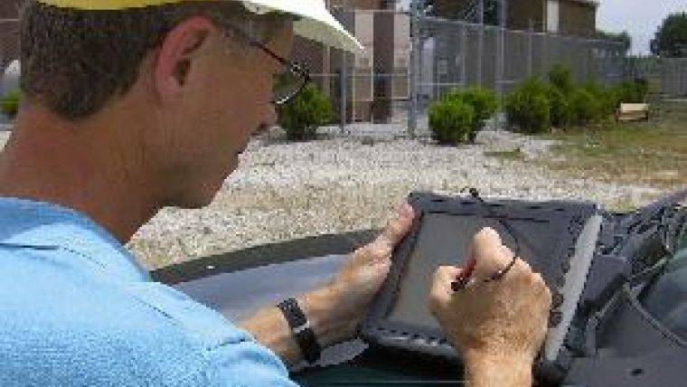
Now that the BlackBerry, iPhone and other smart phones can be purchased at the corner shop, a smart manager might well shake his head and ask himself why he is still sending out crews with paper maps. Why, in fact, do we transmit digital data to a plotter at all? Why not send it directly to a laptop, tablet PC or smart phone via the internet (Figure 1)? Field workers can then, on the spot, query and analyse digital maps, view aerial imagery and upload updates to the central GIS (Figure 2). When they are missing data they can send a request and receive what they need back from the office wirelessly and instantly. Office and fieldworkers can immediately view and use such updates; a great advance in efficiency and cost cutting...!
The technology is in place, and vendors of GIS and survey equipment, well aware that clients do not need tools but solutions, help apply mobile GIS-aided changes in work processes. Esri, for example, has modified and extended its ArcGIS for use in the field and provides solutions in which its mobile GIS is embedded in handhelds, usually those from the Trimble stable. These systems can be wirelessly linked with a central server (Figure 3).
Since field crews often form a large part of the total workforce, even up to 60%, the units sold may add up to hundreds or even thousands.
Tripod
The development of this technology stems from three directions: the GIS industry, producers of mapping tools, and the survey/navigation industry. Coming at it from the GIS side, vendors offer software featuring a suite of GIS functionality including map navigation (zoom, pan, map rotation), geometric computations (distance, area), display, editing, updating and collecting, storing and mapping of GNSS measurements and adding attribute values to collected point, line and area features. Esri provides ArcPad, ArcGIS Mobile and ArcGIS for IOS (IOS is the operating system for the iPhone, iPad, and iPod touch); Intergraph provides Field Automation; and the Taiwanese company SuperGeo, established in 2001, offers SuperPad, SuperField and SuperGIS Mobile Engine. Vendors of mapping tools were initially aiming to relieve the work of the surveyor collecting data with a total station , GNSS receiver or other positioning device. Now vendors such as DigiTerra and Penmap have penetrated the mobile-GIS market. Penmap software is sold embedded in Trimble handheld devices as out-of-the-box solutions for diverse applications such as cadastral surveying, defence and utilities. Software from the Hungarian company DigiTerra evolved from a mapping tool for forestry and farming to become a mobile GIS comparable with Esri's ArcPad. Survey/navigation companies including Ashtech, Javad, Leica Geosystems, Topcon and Trimble all produce handheld devices focused on GNSS positioning. Beijing-based UniStrong, established in 1994 and now employing over a thousand, started out as a GNSS company. One of its products is the Odin handheld, equipped with proprietary software. Usually such software is less sophisticated than GIS in terms of what it offers, as it is designed to be wirelessly linked to the central GIS. But some use OEM (original equipment manufacturer) versions of products made by GIS vendors. For example, Leica Zeno Field is an OEM version of ArcPad 8.
Wireless
Wireless connection enables download of geo-data from the central GIS while in the field, and upload of field data either instantly or at set times. Three types are in use: wireless local area network (WLAN), general packet radio service (GPRS) and Bluetooth. WLAN connects two or more devices through an access point, which enables moving around while connected to the wider internet. To ensure effective deployment, the WLAN infrastructure must cover the whole area in which fieldworkers are operating. An alternative is GPRS provided by mobile-phone operators, but these may suffer from delays due to high latency connection, low transfer speed and selective service availability and coverage. Bluetooth is not able to bridge long distances, but is well suited for transferring data from one device to other nearby devices fast and reliably; it can work over 100m, while no line of sight is required.
Precision
The GNSS precision features listed by vendors usually come along with recording conditions such as minimum number of satellites, maximum PDOP (Positional Dilution of Precision), minimum (cut-off) angle above horizon, and signal-to-noise ratio. This is a clue as to complexity. Precision depends on the number of channels, the actual number of signals picked up, software capabilities, GNSS augmentation services used, and the facilities to cope with atmospheric delays and multipath. Remedies used to diminish atmospheric degradation include dual-frequency measurements and Differential GPS (DGPS); the latter an augmentation approach that corrects for errors using a base station with known coordinates. Comparison with continuously measured coordinates enables computation of corrections 24/7, and these are transmitted in real time by radio link or mobile phone. Precision is at sub-centimetre level. In autonomous mode, that is standalone and without augmentation, precision reads 5m to 15m.
SBAS
In addition to ground-based services there exist satellite-based augmentation services (SBAS), which support wide-area or regional DGPS through measurements taken at multiple base-stations. Corrections are sent to one or more satellites, which broadcast these to enabled receivers. Precision figures here range from five metres to sub-metre in real time. The US operates the Wide Area Augmentation System (WAAS) and Europe has developed its own Euro Geostationary Navigation Overlay Service (EGNOS). Asia will be covered by the Japanese Multi-Functional Satellite Augmentation System (MSAS) and India's GPS Aided GEO Augmented Navigation-Technology Demonstration System (GAGAN). These SBAS systems are publicly funded and free of charge. Commercial SBAS services are also on offer. For example, Fugro's OmniSTAR operates worldwide, providing precision at decimetre level in high-performance mode using dual-frequency GNSS. A variety of professionals are willing to pay for SBAS services, as they rely on accuracy, permanent availability, wide coverage and 24/7 support.
Dip and Drop
Mobile GIS systems operate under a variety of weather conditions, terrain characteristics and working constraints. The setting can be harsh, from extreme cold to hot and highly humid. The device may suffer a drop from the bonnet of a vehicle onto concrete, or plunge into water. So it is imperative enquire as to the durability of the system. Several standards are in use, one being the International Protection Rating Code (IP), which indicates durability by IP followed by two digits, for example IP66. The first digit indicates how the cover protects against intrusion of dust and other harmful particles; 6 is the highest level (complete shield). The second digit indicates the level of water resistance; 5 and 6 mean the device is protected against heavy showers, and 8 is the highest level (survives a plunge into the sea). The IP code can also be extended with a letter and a digit. For example, IPX4 means the device is protected against splashing water. As survey devices often originate in the military, the United States Military Standard (MIL-STD-810) is also in use, addressing much broader operational settings than does the IP standard, including air pressure, lowest and highest temperature, temperature shock, humidity, salt fog, gunfire and random vibration. The qualification is gained in the laboratory where real-world conditions can be only partially duplicated, so that it remains necessary for the professional to exercise their engineering judgment.
Peripherals
Most devices use Windows Mobile (WM), initially developed for the consumer market. However, as sales have been falling continuously to a present fifth position on the global market, Microsoft is now focusing on the specialised market for rugged mobile devices. A stylus pen or the operator's finger allows them to tap commands onto the touch-sensitive screen (Figure 4). Equipped with handwriting-recognition software, the device converts written annotations into letter code. When an object is difficult to access, its position can be determined as an offset point from distance and bearing measured with an integrated laser rangefinder and electronic compass. A forthcoming and more accurate alternative to the latter is an inertial navigation system (INS) based on micro-electromechanical system (MEMS) technology. The miniaturisation of accelerometers and gyroscopes has matured to the point where now low-cost commercialisation has become viable. Applications may benefit from geo-tagged imagery of fire hydrants, traffic barriers and other street furniture recorded by a digital camera and stored on a Secure Digital (SD) card, allowing storage of 4GB, SDHC (high-capacity) card (32GB), or SDXC (eXtended Capacity) card, storage capacity 2TB.
Performance Test
Before purchase it's a good idea to take any mobile GIS system into the field. As GNSS precision is a multifaceted topic, the best performance test is to check measurements against ground truth. A feasible set-up is measuring a set of known points distributed over an urban area with no obstructing tall objects, so that there are sufficient satellites more than 15 degrees above the horizon. Write annotations on the touch screen, make photos, and measure offset points using range-finder and electronic compass. Compute the coordinates in post-processing and compare these with existing coordinates with a precision at least ten times better.
To determine sensitivity to multipath, position the instrument under canopy and measure, preferably whole day long. Plot the coordinates and use a map or orthoimage as backdrop, check the size and pattern of dispersion and compute the standard deviation. To test real-time performance, walk along some straight lines, such as those demarcating a car park, and judge the jagged nature of the recorded path (Figure 5).
Applications
Shanghai recently created a database of its nine million trees. In order to inspect their health, fieldworkers use Juno SC handhelds from Trimble to navigate to sample trees. There they collect data by filling in a digital form which is sent to the office, where it is checked right away for completeness. Mistakes are reported back while the fieldworker is still close to the tree. The figures can also provide statistics to serve managers. Antalya in Turkey is a rapidly, partially organically expanding urban area populated by over one million souls. To support repair and extension of its drinking-water and sewerage pipelines a GIS database has been created from existing maps. Updates at cm-accuracy are collected using Topcon GRS-1, which is able to process RTK corrections running DigiTerra Explorer. To help field crew map its underground fibre-optic cables, Slovak Telkom Group developed a method based on a cable locator and Ashtech MobileMapper equipped with Geolantis software. A consumer-owned supplier of electric power serving over 26,000 households and businesses in north-eastern Indiana (US) replaced its outdated paper maps by a digital geo-data set. Using Esri software and GNSS devices built into their laptops, field workers can now view, search and revise geo-data and use GNSS for facility locating and routing.

Value staying current with geomatics?
Stay on the map with our expertly curated newsletters.
We provide educational insights, industry updates, and inspiring stories to help you learn, grow, and reach your full potential in your field. Don't miss out - subscribe today and ensure you're always informed, educated, and inspired.
Choose your newsletter(s)


