Mobile Mapping Trends and Insights
Data Analysis by Geomares
Mobile mapping technology is on the rise worldwide. Industry specialist Geomares – publisher of 'GIM International' among other things – has analysed the user data and behaviour of thousands of members of the global geospatial community. This article presents the findings from that analysis, identifying the latest trends and sharing insights into the future outlook for mobile mapping.
Recent advances in mobile mapping technology are enabling new capabilities and complementing – or even replacing – traditional survey methods of topographical surveying. Futhermore, widespread investment in city planning and ‘smart city’ projects is expected to further accelerate the adoption of mobile mapping technology worldwide. 450,000 geomatics professionals visited the GIM International and/or Geo-matching websites in 2017, and a large percentage of those online visitors were interested in mobile mapping systems. This puts Geomares in a unique position to analyse website behaviour to discover trends and insights related to mobile mapping systems. To provide a balanced overview, this analysis is based on a combination of Geo-matching website data, the GIM International readers’ survey, Google search statistics and market research.
Behaviour of Geo-matching Users
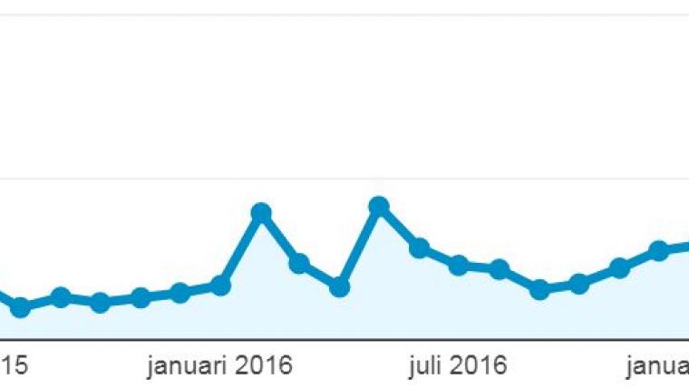
Data from the Geo-matching website shows strong growth in interest in mobile mappers. Geo-matching is the world’s largest product platform for surveying, positioning and machine guidance, listing more than 2,000 products from 500 manufacturers and attracting more than 250,000 users in 2017. Mobile mapping technology is one of Geo-matching’s most important sections, featuring 52 products from 25 manufacturers. In mid-2017 and 2018 , Geo-matching started paying extra special attention to mobile mapping systems, with direct success. Since September 2017 the number of page views has more than doubled (see Figure 1). This shows that there is a strong interest in mobile mapping systems. In June 2018 more than 3,300 mobile mapping pages were viewed – an absolute record.
Readers’ Survey Data
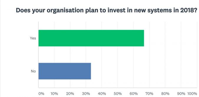
GIM International regularly surveys its readers on a number of topics, and the latest survey was conducted in December 2017 (615 respondents). 67% of the respondents indicated plans to invest in new systems in 2018 (Figure 2).
GIM International also asked its readers which type of systems they plan to invest in. 20% of the respondents plan to invest in mobile mapping systems and/or portable and indoor mobile mapping systems. These results are a strong signal that geospatial professionals are considering the purchase of mobile mapping systems, and that level of demand is expected to rise further in 2018 and beyond.
Another question asked which trends geospatial professionals foresee in their industry over the next five years. The increasing role of mobile mapping systems is one of the most striking outcomes that can be derived from the survey results. Mobile mapping systems also go hand in hand with the need for more accurate 3D city models, as mentioned by some respondents.
Google Search Statistics
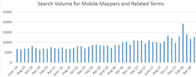
Google Keyword Planner was used to study the search volume for mobile mappers worldwide (see Figure 3) from 2014-2018. Google statistics show that a strong increase in the search volume for mobile mappers. In 2016 there were on average 9,000 searches per month, compared with 7,000 in 2014. The average for 2018 currently stands at about 14,000 searches per month, representing an especially steep growth (of approximately 65%) in search volume from 2016 to 2018. These figures include searches for mobile mappers and similar terms such as mobile laser scanning, mobile mapping system, indoor mobile mapping and so on, but do not include specific brand or product names.
Geo-matching Profile of Typical Mobile Mapping Users
Since 2012 thousands of geospatial professionals have used Geo-matching to contact manufacturers directly. This gives Geo-matching a unique insight in the user types looking for mobile mapping technology. In 2015 Geo-matching included just 16 mobile mapping systems, whereas it now features 52 – an increase of 325% in the space of three years.
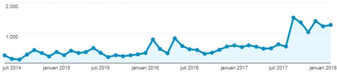
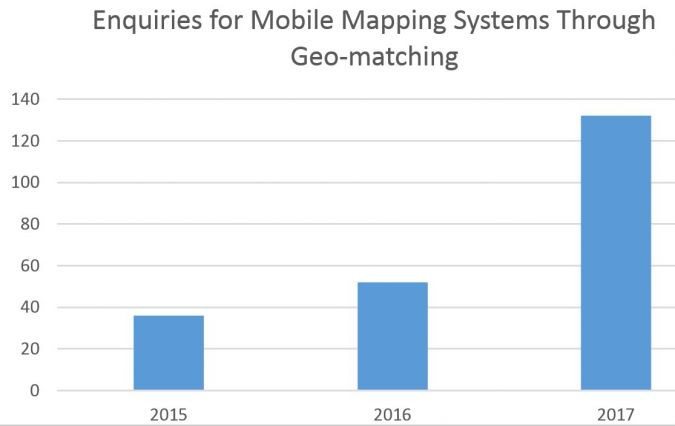
Geo-matching has seen enquiries ranging from major organisations like NASA and the US Army of Engineers to surveying companies of all shapes and sizes worldwide. Enquiries have also come from infrastructure companies (e.g. road survey, corridor mapping, etc.), maritime companies (monitoring of harbour walls), forensics (crime mapping and traffic accident investigation), mining (open-pit survey, etc.) and even some surprising sources such as New York City’s Metropolitan Opera House (indoor mapping for maintenance and monitoring purposes). In 2015, 36 enquiries were made through Geo-matching, rising to 52 enquiries in 2016 and 132 in 2017 (Figure 4): a 250% increase from 2016 to 2017. The growing number of enquiries made on Geo-matching is a clear sign that mobile mapping applications are incredibly diverse and that new potential customers have entered the market in recent years. Geomares attributes this increase to greater general interest in mobile mapping systems, Geo-matching’s stronger focus on the topic of mobile mapping and the fact that there are more mobile mapping systems listed on Geo-matching.
Regional Distribution
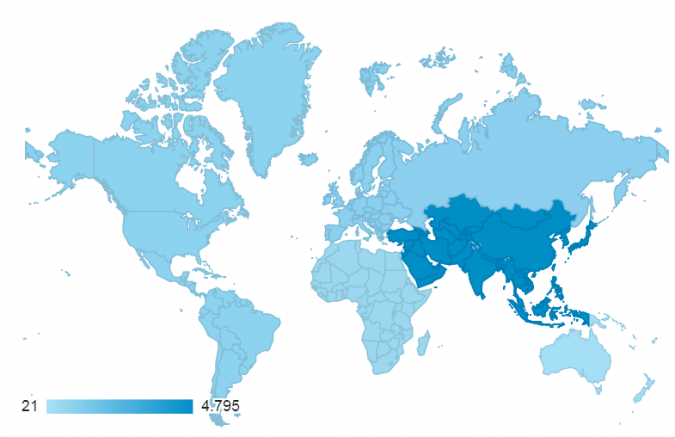
Although mobile mapping technology is used worldwide, 50% of all users looking for mobile mapping technology on Geo-matching are from the Asia-Pacific region (see Figure 5). This is an interesting finding that is supported by other market research stating that increased investment to develop infrastructure in Asia-Pacific – the need for which is created by the process of hyper-urbanisation that is currently underway across the region – will boost demand for mobile mapping technology. As mentioned in the highly recommended article called ‘Mobile Laser Scanning Point Clouds’, published by GIM International in 2017, “the demand for 3D maps of cities and road networks is steadily increasing and mobile mapping systems are often the preferred geodata acquisition method for capturing such scenes”. This is exactly what is going on in the Asia-Pacific region right now.
Significant growth
Geo-matching website data, the GIM International readers’ survey, Google search statistics and market research all show clearly that the demand for mobile mapping technology has increased over recent years. Based on the findings from the readers’ survey and other market research reports, it is safe to say that geospatial professionals worldwide will increase their investments in mobile technology in the coming years.
The value of the global mobile mapping market is expected to reach US$32 billion by 2023 at an average growth rate of 21.3% per year. Substantial growth can be anticipated in North America and Europe because of the high potential of organisations that can implement mobile mapping technology and the large number of mobile mapping service providers. Market research anticipates, however, that the Asia-Pacific region will grow the fastest, with India, Japan and China leading the way. This is attributed to increased investment for developing infrastructure, which includes city planning and smart city projects.
50% of all mobile mapping pages on Geo-matching are viewed by visitors from the Asia-Pacific region. This shows that there is a strong interest in mobile mapping technology in that region and is consistent with the above-mentioned market research.
Types of Mobile Mapping Systems
Mobile Mappers
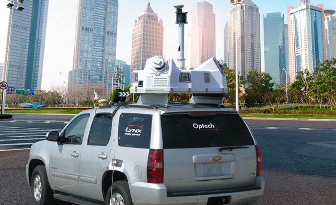
When thinking about mobile mapping, most people probably associate it with vehicle-mounted systems or ‘mobile mappers’. These devices that collect geospatial data from a mobile vehicle, typically fitted with a range of photographic, radar, Lidar or any number of remote sensing systems. Such systems are composed of an integrated array of time-synchronised navigation sensors and imaging sensors mounted on a mobile platform and used for outdoor applications. The increasing demand for 3D maps of cities and road networks and the need for up-to-date 3D models form the key pillars of the expected growth of the global mobile mapping market.
Portable and Indoor Mobile Mappers
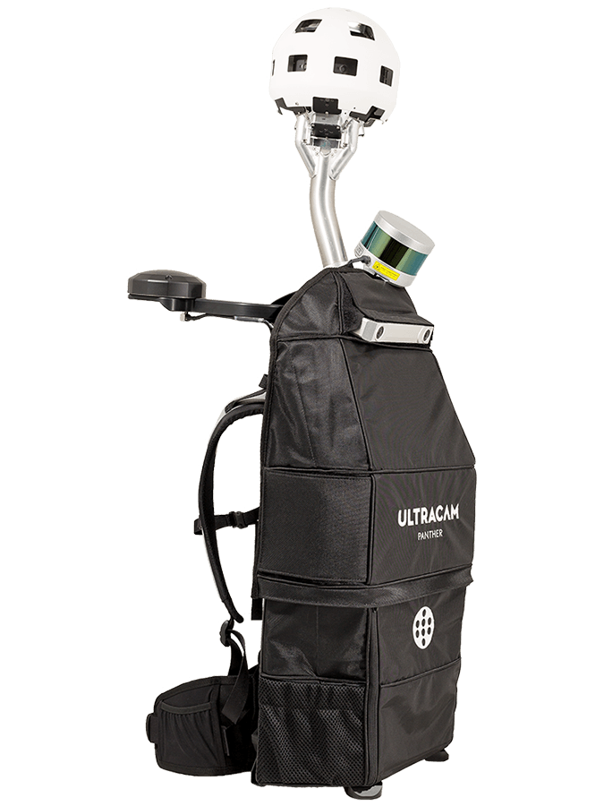
Portable and indoor mobile mappers have entered the market over the past few years. The indoor counterparts of mobile mappers, portable and indoor mobile mappers fit in a backpack or are a compact mobile device. They scan indoor environments with either cameras or laser scanners. Datasets are georeferenced and point clouds can be coloured using cameras or laser scanners. Portable and indoor mapping solutions are applied to obtain accurate representations of 3D interiors in infrastructure such as underground mines and tunnels, plants and factories, airports, shopping malls, etc.
5 Important Considerations When Purchasing a Mobile Mapping System
- Application – Type of Mobile Mapper
The application is a very important consideration for purchasing a mobile mapping system. If you want to map outdoor terrain (e.g. a mine or a highway) a vehicle-mounted mobile mapping system is usually most suitable. If you plan to map indoor environments (e.g. rooms, corridors, production locations) a portable and indoor mobile mapper may be more suitable.
- Photogrammetric or Lidar Camera
Photogrammetry or Lidar point clouds? Both have their advantages, and the most suitable one depends on the particular application. There is one key difference that distinguishes photogrammetry from Lidar, namely RGB. Photogrammetric point clouds have an RGB value for each point, resulting in a colourised point cloud. On the other hand, when it comes to accuracy Lidar is hard to beat. But not all projects require the same accuracy, which is why it is always good to do some research first before you decide which method works best for you.
- Processing Software
In the article called ‘Comparing Lidar and Photogrammetric Point Clouds’, which appeared in GIM International’s January/February 2018 issue, point clouds are compared for inspecting a flood control structure. In this scenario, Lidar output takes far less time to process and provides a clean and sharp point cloud that is easy to work with. The photogrammetric data collection and processing took slightly longer and the point cloud required extensive cleaning.
- GNSS/INS Positioning System
Operating in buildings, tunnels and mines requires advanced solutions since there is no GNSS coverage. This is important to consider when choosing a GNSS/INS system for your mobile mapper.
- Compatibility
The ongoing miniaturisation of sensors and electronics has led to the construction of laser scanners which are light enough to be mounted on an unmanned aerial system (UAS), trolley, backpack or stick. Some mobile mapping systems compatible with a variety of applications from multiple systems (UAS, backpack, car, etc.).
This article is based on the combination of content from various sources to provide general trends and insights related to mobile mapping. For more research data, reader survey details and/or a personalised report, please contact Sybout Wijma (sybout.wijma@geomares.nl).
References
1. http://www.reportsweb.com/mobile-mapping-global-market-outlook-2016-2022
2. https://news.nationalgeographic.com/2018/02/maya-laser-lidar-guatemala-pacunam/ Mobile Mapping Market Research Report – Forecast to 2023
3. https://www.marketresearchfuture.com/reports/mobile-mapping-market-5747
4. https://www.gim-international.com/content/article/comparing-lidar-and-photogrammetric-point-clouds
5. GIM International: ‘Mobile Mapping’ by Mathias Lemmens (See July-August issue, Editorial Note, page 5)

Value staying current with geomatics?
Stay on the map with our expertly curated newsletters.
We provide educational insights, industry updates, and inspiring stories to help you learn, grow, and reach your full potential in your field. Don't miss out - subscribe today and ensure you're always informed, educated, and inspired.
Choose your newsletter(s)


