Multi-sensor UAV Project Secures Digital Preservation of Indian Landmark
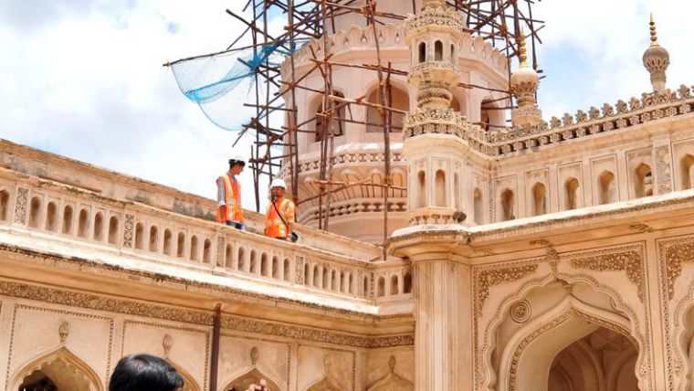
Terra Drone India has recently successfully completed a multi-sensor, multi-platform scanning project of the internationally recognized landmark Charminar. Built in 1591, the monument, which is often called the ‘Arc de Triomphe of the East’, suffered significant damage in May 2019 when a huge chunk of lime plaster from its south-west minaret broke and fell off. This incident made the digital preservation of Charminar extremely time-sensitive and important for the Indian government. The IT department of Telangana state government invited Terra Drone India to provide innovative technological solutions for the digital preservation of Charminar.
Terra Drone India scanned and surveyed the damaged minaret using multiple technologies. The total solution included several steps, which are briefly summarized below.
- Air Gap Measurement through Ultrasonic Pulse Velocity Testing Technique:The Archaeological Survey of India, the Indian government body responsible for archaeological research and the conservation and preservation of cultural monuments in the country, had expressed concern regarding the increasing air gap between the plaster and the actual facade of Charminar. Terra Drone India carried out Ultrasonic Pulse Velocity Testing, a non-destructive testing technique, to measure the air gaps that have developed in the areas of concern to date.
- True-colour 3D Model Creation using Visual (RGB) Sensor:A high-accuracy visual (RGB) scan was carried out to maintain a record of the facade, actual colour and any visible cracks or crevices. From this, a true-colour 3D model will be created.
- Thermal Scanning: The thermal scan was conducted to detect differences in temperature between different areas of the monument and identify how the different materials used in the monument are reacting to heat and how they are at risk of damage.
- Lidar 3D Profiling and Model Generation using Lidar: In order to preserve the current existing infrastructural design and layout of the monument for future rebuilding or repair works, a Lidar survey was carried out to create a high-accuracy 3D model, accurate to the millimetre level.
Wing Commander Polu Sreedhar, chief operating office of Terra Drone India, commented: “Heritage monuments like Charminar are the treasures of our nation and symbolize the pride of our civilization. Terra Drone India has collated multiple technologies under one umbrella and provided it as a holistic solution to the Archaeological Survey of India to help preserve the monument that speaks volumes about our Indian heritage, culture and ancestral prominence.”

Value staying current with geomatics?
Stay on the map with our expertly curated newsletters.
We provide educational insights, industry updates, and inspiring stories to help you learn, grow, and reach your full potential in your field. Don't miss out - subscribe today and ensure you're always informed, educated, and inspired.
Choose your newsletter(s)


