Orbit GT Launches Mobile Mapping Publisher 10.5
Orbit GeoSpatial Technologies has announced the availability of Mobile Mapping Publisher version 10.5, a recognised solution for publishing on the web and sharing huge volumes of mobile mapping content. Version 10.5 again adds numerous new features to this solution for sharing mobile mapping content. The MM Publisher now adds support for large-size imagery and point cloud visualisation.
Although the company sees this as a major technology breakthrough, at the same time it is being regarded as a business requirement for today’s captivation systems. Mobile Mapping Publisher 10.5 is a professional alternative to other online street-level imagery services.
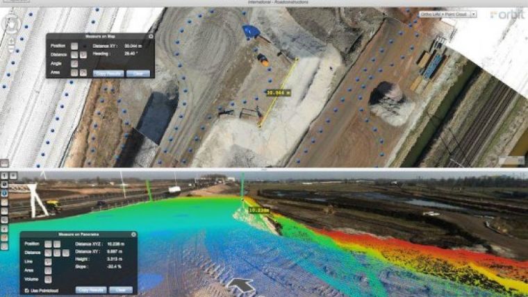
A versatile tool to share the huge volumes of mobile mapping data to a wide variety of users, version 10.5 adds a considerable list of features of which these are the most eye-catching: possibility to define multiple projects with label and colour, huge performance improvement for large panoramic imagery, visualisation overlay of Lidar data, on-the-fly CRS conversion capabilities, a wide range of real time measurement improvements such as volume measurement, results display in several CRS, slope results, @D measurements, heading measurement, angle measurement and more; a configurable search and embedding of a geocoding engine of your choice, layout up to 4 panoramas in tiled view, dynamic display of photo recording position from a larger scale onwards, and more.
The 10.5 Publisher also comes with an updated API for embedding in Flex, JavaScript and dotNet. This API has been extended to support all new features, including an image snapshot feature at set dimensions. Embedded solutions for ArcGIS and AutoCAD are to follow this upgrade to 10.5 soon. As is the case for all of the 10.5 portfolio, the MM Publisher supports any imagery, Lidar and setup for mobile mapping captivation systems and is 100% vendor neutral. Online publication does require a 360° image for proper user navigation.

Value staying current with geomatics?
Stay on the map with our expertly curated newsletters.
We provide educational insights, industry updates, and inspiring stories to help you learn, grow, and reach your full potential in your field. Don't miss out - subscribe today and ensure you're always informed, educated, and inspired.
Choose your newsletter(s)


