Pioneering Bespoke Small-scale Aerial Mapping
Since 2009 Blom Germany have been working with SmartPlanes to develop a cost-effective light-weight UAV solution for the European market. With more than a hundred trials and now some ten commercial projects completed since early 2010, the Personal Aerial Mapping System (PAMS) technology is being rolled out to other countries in the Blom Group. A recent example was the successful completion of the ortho mapping of the two towns; Panasesti (North West of Chisinau) and Isacova, both in Moldova. Recent PAMS operations have also been completed in Austria, Netherlands and Germany.
The PAMS-developed SmartPlanes of Sweden includes the plug & play system and the rapid post processing solution developed by Germatics (Blom Germany's daughter company) that turns the flight imagery into an orthophoto and DTM for survey analysis. SmartPlanes have also completed successful operations in the UK, Sweden, Norway and Denmark.
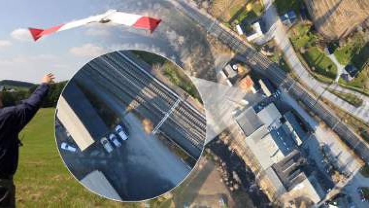
The projects to date have been for survey and mapping applications of villages, golf courses, train stations, quarries, waste dumps, agriculture and forest areas to name a few examples. Orthophoto mosaics, digital terrain models and even 3D vector mapping can be produced from the imagery, typically captured between 5cm and 8cm GSD.
Blom has started offering operation of the UAV service from their Cheddar Office in the UK. In this current economic climate, the service can deliver low-cost bespoke aerial imagery, digital models and mapping. In addition to sites that would be traditionally surveyed from the air, the system particularly allows mapping of smaller open rural areas which might have required a total station or RTK GPS survey. It is particularly suited to these sites where access is difficult and where health and safety restrictions prevent ground survey. It has proved to be most economic over sites that are too large for rapid land survey, yet too small to be cost effective for traditional, manned-aircraft aerial survey.
Generally surveys can be completed within two weeks of order, subject to weather, with some 5 to 6 sqkm captured per day.

Value staying current with geomatics?
Stay on the map with our expertly curated newsletters.
We provide educational insights, industry updates, and inspiring stories to help you learn, grow, and reach your full potential in your field. Don't miss out - subscribe today and ensure you're always informed, educated, and inspired.
Choose your newsletter(s)


