Rapid Survey Technology for Puerto Rico Earthquake Response
Geoxphere and WaldoAir Assist from the Air and on the Ground
This article was originally published in Geomatics World.
A series of strong earthquakes recently hit populated areas in the south of the Caribbean island of Puerto Rico, causing major damage to properties and infrastructure. Geoxphere and WaldoAir were mobilized to assist in the disaster response effort. Tasked with capturing detailed photography from both the air and the ground, which was a first in this context, the team utilized their XCAM and XCAM360 rapid survey technology, with XMAP as the cloud-based data delivery tool.
When a natural disaster such as a hurricane, earthquake or flood occurs, it is important to establish the extent of the damage, the risk to life and the conditions on the ground in order to prioritize relief. The strongest in the series of earthquakes in Puerto Rico in late December 2019 and early January 2020 topped a magnitude of 6.4, and there were several other quakes above 5.0 plus many more aftershocks. For this reason, the potential impact to life and infrastructure was considerable.
The Federal Emergency Management Agency (FEMA) mobilized Geoxphere and WaldoAir to assist in the disaster response effort. Prior to this mobilization, teams at Civil Air Patrol (CAP) and FEMA had used WaldoAir’s airborne camera systems to capture high-resolution photography quickly and systematically. The data, usually captured as high and low oblique imagery, is then processed into 3D mesh models, point clouds and orthophotos ready for analysts to assess the extent of the damage and calculate volumes (of debris, for example).
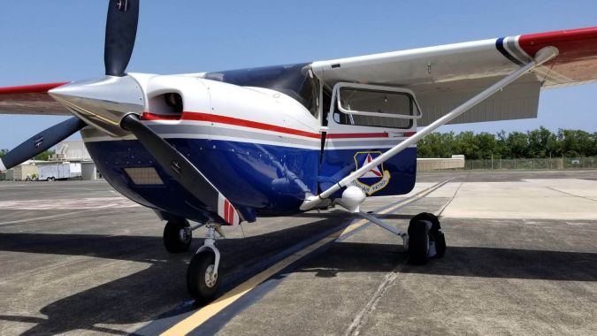
For the incident in Puerto Rico, a fleet of CAP aircraft was deployed fitted with WaldoAir XCAM Ultra50 cameras. However, earthquake damage can be difficult to see from the air, so CAP and FEMA also mobilized Geoxphere’s XCAM360 road-based mobile mapping system. The task was to capture systematic ground-based imagery of earthquake damage which could be used to supplement the airborne imagery.
Portable, rapid mobile mapping technology
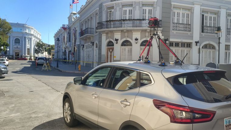
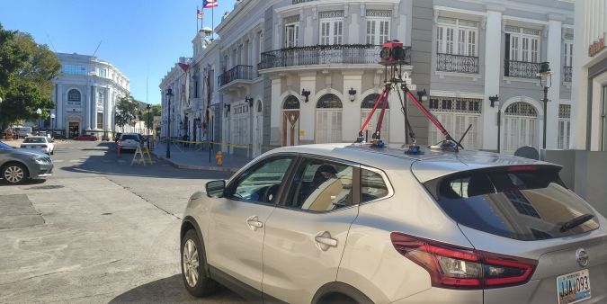
The XCAM360 is a portable mobile mapping system developed in-house by Geoxphere. It combines off-the-shelf components and proprietary technology to give a system that is easy to use, easy to deploy and fits on to any vehicle. The navigation screen mounted in clear view of the driver gives an overview of the system status as well as a moving map that shows what needs to be captured and how much is left to do. The high-grade inertial navigation system (INS) captures roll, pitch and yaw information as well as GPS and GLONASS positioning data. The INS is the controller for the imaging unit and can be set to fire the camera array at regular distances. In this project, a 30MP panorama was captured every 5 metres, giving a positional accuracy of less than +/-26cm. The system requires only minimal training (and a driver’s licence) to be used.
Unlike more expensive mobile mapping systems, the current XCAM360 does not have a Lidar unit integrated. This is a deliberate omission, as point cloud data has no practical place in the workflow for analysis of the street scene. Moreover, Lidar adds considerable unnecessary costs and processing overheads to the operation. These are all negative points when delivering responsive mapping data back to the disaster management team. Intuitive data is of the utmost importance. This is true of many other non-emergency mobile mapping applications where Lidar is unnecessarily used. If the analysts can see clear panoramic photography without having to interpret a point cloud, then they have all they need to do their job effectively.
CAP volunteer pilots
Only one XCAM360 was utilized in this project. It was operated by the joint Geoxphere and WaldoAir team, but CAP volunteer pilots were on hand to assist with the installation and capture of the ground-based imagery. Although driving a medium-sized SUV is a little different to the Cessna 172S Skyhawk aircraft they are used to, this project showed that the work can be managed by the existing operators if this method needs to be deployed on a larger scale.
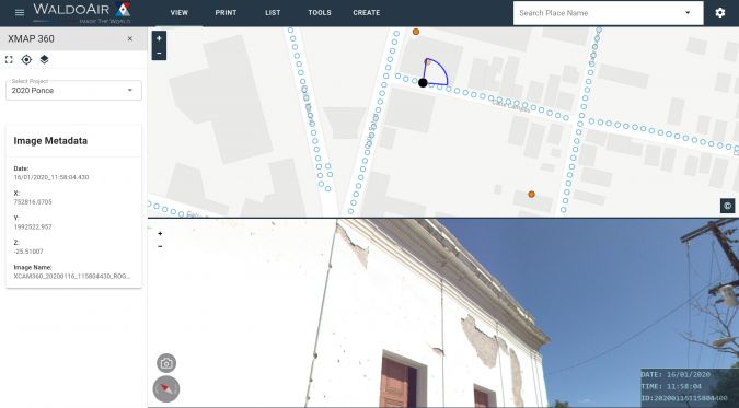
The selected project sites were areas in the south of the island of Puerto Rico. The epicentres for many of the larger earthquakes were around the towns of Guánica, Yauco, Guayanilla and Ponce. These towns suffered the worst damage and needed the most relief effort.
The human aspect
One of the starkest differences between ground-based surveying and aerial surveying is that the ground-based surveyor sees the effects of the disaster – and the people that the information will soon be helping – from up close rather than remotely. The retro-fitted survey vehicle aroused the curiosity of the locals who remained in their neighbourhoods, and many stopped to talk to the surveyor. As a result, the operator experienced the sense of community following such a disaster first-hand: from aid crews delivering essential water to people camped in tents outside the front of their house, to support groups meeting elderly residents and even locals dressed as clowns handing out supplies and entertaining the children.
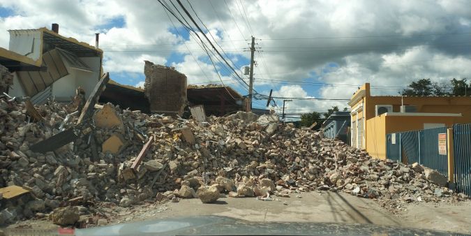
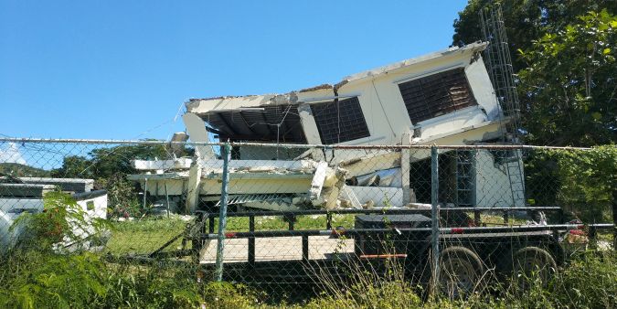
The benefit of street-based imagery became clear as the surveyor drove around the neighbourhoods. Many buildings in the region sit on stilts, particularly in coastal tsunami-prone areas. In many cases, the concrete had cracked at the top, exposing twisted steel and damaging the stilts to such an extent that it was clear that numerous buildings would have to be rebuilt. That level of detail is not visible in airborne datasets.
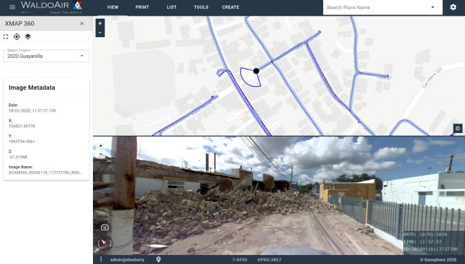
Processing and cloud-based delivery
For this project to have maximum impact, the survey data needed to be processed and delivered to the assessment team back in mainland USA as quickly as possible. To achieve this, processing of the imagery and INS data was started on board the XCAM360 system as soon as the survey ended. By the time the survey car was back at base, over 60% of the imagery captured that day had been processed into a ready state. This is not possible with most traditional mobile mapping systems.
With the imagery processed and the post-processed orientation information assigned to each frame, the data was then pushed directly to a Geoxphere cloud server and read by XMAP. XMAP is a fully cloud-based GIS system that can be configured to display a range of map data and deployed to staff instantly. For this project, an XMAP account was created and populated with base mapping, NOAA imagery captured from post-Hurricane Maria, point data highlighting damage reports that had been collected by walking teams and, most importantly, the 360 imagery. For the 360 imagery viewer, Geoxphere partnered with Spanish company Voxel3D to ensure the imagery was delivered in the most efficient way, giving fast loading speeds and an intuitive interface.

Data usage
Within 24 hours of the first survey, a team of assessors were examining the 360 imagery. Their task was to use the imagery to derive the impact of the earthquake on different communities, to decide where assistance should be focused, and to identify sites suitable for temporary housing. Even though this project was only a demonstration of the system’s capabilities, the data that was captured was found to be critical in helping the relief effort. Not only was this imagery useful for this response, it can also act as a definitive record for comparison in any future incidents in that area.
Conclusion
The success of this exercise shows that deploying fit-for-purpose technology in a timely way can have great benefits for downstream disaster-management operations. There is a tendency for mission planners to over-specify survey requirements and to default to high-end systems without questioning whether smaller and more mobile systems are fit for purpose. It is highly significant that FEMA, the world’s most sophisticated disaster relief organization, has recognized that the combination of XCAM and XMAP technology provides the most effective data with the shortest possible delay. This ensures that relief aid can be delivered to the people who need it most. The Geoxphere and WaldoAir teams are prepared to be mobilized for any project that needs a timely response, whether for commercial, government, military or disaster response purposes. The XCAM and XMAP technology is constantly evolving to meet the needs of these applications. The manufacturer plans to upgrade XMAP so that the orthophotos, oblique aerial imagery and the 360 ground-based imagery can be viewed in an integrated way. This will give the assessor a comprehensive decision-making platform that can be shared amongst colleagues around the world in a quick and intuitive way.
Acknowledgements
The Geoxphere and WaldoAir team would like to thank FEMA and CAP who were instrumental in enabling the project.

Value staying current with geomatics?
Stay on the map with our expertly curated newsletters.
We provide educational insights, industry updates, and inspiring stories to help you learn, grow, and reach your full potential in your field. Don't miss out - subscribe today and ensure you're always informed, educated, and inspired.
Choose your newsletter(s)


