Remote GeoSystems Adds Direct Support for DJI Inspire 1 UAV Video
Remote GeoSystems, specialised in geospatial full motion video (FMV) solutions, has announced direct support in all LineVision cloud, server and desktop applications for the world’s most popular UAV for HD and UltraHD video capture. This new LineVision capability immediately offers tens of thousands of DJI Inspire 1 operators and pilots the ability to create and deliver interactive professional-grade video inspection and survey work products using some of the world’s most ubiquitous GIS & CAD software including the Esri ArcGIS platform, Bing Maps, Google Earth and PLS-CADD.
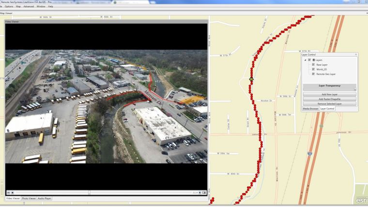
DJI Inspire 1 users just need to enable .SRT file logging while recording video during flight. Post-flight, LineVision will allow them to load or upload the video and GPS track to a map. As the video plays, a cursor moves along the GPS track on the map, constantly indicating where and when the current video view was captured based on GPS data logged during the mission.
Place and time
Users can geographically navigate the video recordings by simply clicking any of the points along the GPS track on a map. The video then automatically advances or reverses to that point in the video so that analysts and subject matter experts can visually interpret what was recorded at that specific place and time.
In addition to FMV, LineVision features import/upload and “one-click" geo-referencing of nearly any kind of rich media including photos, audio and virtually any electronic documents or files (PDF, Microsoft Office, CAD files, etc.)
LineVision features flexible mapping options allowing you to incorporate and "stream" background maps and data layers from your enterprise GIS and 3rd-party map service providers.
All these imported data types can be saved in a Remote GeoSystems .geoProject file for data portability and future analysis in LineVision software.
The Remote GeoSystems technology has been developed commercially and independent of defense programs, making it easier for non-military customers outside the US and around the globe to acquire the applications and expertise without having to go through the often lengthy ITAR export process.

Value staying current with geomatics?
Stay on the map with our expertly curated newsletters.
We provide educational insights, industry updates, and inspiring stories to help you learn, grow, and reach your full potential in your field. Don't miss out - subscribe today and ensure you're always informed, educated, and inspired.
Choose your newsletter(s)


