SA Vineyard Acquisition Programme
Getmapping subsidiary Geosense (South Africa), in partnership with Precision Surveys, has just completed a successful aerial and ground-based acquisition programme in the Western Cape focused primarily on the wine-producing regions. The programme undertaken during February and March of this year captured over 130,000 hectares of vineyards, including farms in CapeTown, Hermanus, Grabouw, Stellenbosch, Franschoek and Piketberg.
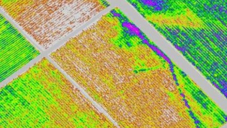
The programme provides Viticulturists with true-colour and colour infrared orthorectified imagery as well as a normalised difference vegetation index (NDVI) map at high resolution (25cm Ground Sampled Distance). These are used as tools to assess the quality of the vines pre-veraison (prior to ripening).
Timing is crucial as the maps must be provided when the fruit is still on the vine. Vineyards are normally divided into blocks and are frequently not uniform. The maps indicate the vines vitality and vigour and allow the wine maker to grade the vines into sub-blocks or ‘zonal management units’. This helps the winemaker to plan the vintage, enabling batches of similar fruit to be harvested and fermented together.
NDVI maps are also used to indicate potential problems within blocks and as they are orthorectified, field sampling with GPS can be undertaken to determine whether the problems highlighted are pest, nutritional, water or disease related.
“This has been a very successful beginning to our Precision Farming program here in the Western Cape, and development in other agricultural sectors such as apple and citrus crops looks very promising” said Matt Murphy Director of Geosense. “Subsequent data capture will provide customers with even more content and other value added services such as 0.25m contours and irrigation mapping. We intend to make much of this program available in a new online GIS service for farmers towards the end of the year” continued Murphy.

Value staying current with geomatics?
Stay on the map with our expertly curated newsletters.
We provide educational insights, industry updates, and inspiring stories to help you learn, grow, and reach your full potential in your field. Don't miss out - subscribe today and ensure you're always informed, educated, and inspired.
Choose your newsletter(s)


