Smart Surveyors: Developments and Trends from the FIG Working Week 2020
Some of the challenges demanding innovative surveying approaches and technologies are rapid urban growth, smart energy, cleaner mobility, and ‘land rights for all’. Sensing technologies, spatial data processing methods, and related approaches are already available. However, the question is how to use and improve them to become future proof, smart surveyors? Only ten years left to achieve the SDGs for a sustainable future. How can smart surveying contribute? To answer these questions, the papers of the FIG proceedings were analysed by the author-team.In this short article, we present the main trends distilled and the papers we refer to, represent these main trends. We start with a brief review of the Smart Surveyors keynote presentations, followed by main trends described in the regular papers, and finally, a short summary of the impact of the FIG community.
Keynotes
The contributions in plenary session 1 on Smart Surveyors (Ref) are ‘perfectly’ balanced as far as this is possible for three presentations: continents (America, Australia, Europe), sectors (industry, academia, government), topics (geospatial infrastructure, indoor modelling, applications) gender (two male, one female).. Jack Dangermond, Founder and President of Esri, USA, points out that we are moving towards an interconnected network of geospatial web services. Within this geospatial infrastructure, we increasingly depend on a strong foundation of survey information. Sisi Zlatanova, Professor and Head of GRID, UNSW Australia, turns our attention to the, for surveyors, rather unusual indoor domain. She stresses the importance of research in support of indoor mapping and modelling (IMM) with emerging applications such as navigation, facility management, or Smart Cities/Digital twins. Finally, Frank Tierolff, Chairman Executive Board of Kadaster, Netherlands, has a legal background, and in the world of land administration, the legal and the survey profession are tightly connected. The use and applications of new technologies is not only a matter of pure Survey and ICT developments but also a matter of aligned legislation, agreed on and accepted by society.
Fourth industrial revolution
This trend addresses the effects on surveying, photogrammetry, construction, and hydrology of the so-called “fourth industrial revolution” where technologies such as the Internet of Things (IoT), Big Data, and Artificial Intelligence (AI) are dominant. Multiple sessions present the influence of the fourth industrial revolution on the way built environment assets are designed, constructed, and operated. More concreate, they examine the development of BIM, facility management innovations, and machine learning (Ref). Some authors discuss the benefits and adoption of so-called “intelligent building” systems, which aim to find a balance between elements such as data communication, voice automation, lightning, heating, etc. In this vein, the authors provide an overview of the approaches for automated intelligent BIM (Ref) and a link to 3D Cadastre (Ref), (Ref), (Ref). In addition, innovations in capturing, processing, and distribution of Big Data for hydrological applications are also shared in several sessions (Ref). Big data analytics is used to draw new conclusions from pre-existing “old” data, such as previously acquired data from archeological sites, in which Ioannidis et all. discusses the use of big data to automatically document the archeological sites (Ref). Others combine “new” real-time sensor data with big data analytics to gain new insights, applying a technique Leica calls sensor fusion (Ref).
Positioning, navigation and timing (PNT)
Technologies such as sensors are rapidly developed over the past years and are nowadays being used to play vital roles in PNT applications (Ref). For example, Kupriyanov (Ref) is emphasizing on the use of Modern GNSS Technology Implementation in precision agriculture. Nowadays, an accurate and accessible global reference system is the great equalizer in measuring between land/water and data from different sources and also improved hybrid models such as KSA-GEOID17 (Ref). The new Galileo PNT services are looking very promising, with already today the possibility to do high accuracy Galileo Only Cadastral Survey (Ref) and will improve further in the future with the Galileo High Accuracy Service (HAS) (Ref).
Unmanned aerial vehicles (UAVs)
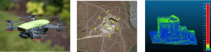
Several studies investigate photogrammetric approaches for smart surveying, using flexible and affordable acquisition technologies such as UAVs and open-source processing solutions (such as Open Drone Map) (Ref). These studies prove the applicability of UAVs for cadastral (Ref) and topographic mapping (Ref), underwater and architectonic photogrammetry (Ref), among others. Investigation on the geometric accuracy using RTK and PPK processing for georeferencing UAV data is shared by Heinz-Juergen Przybilla et al. (Ref). The engineering side showed large technological advancements. However, the tooling and techniques are forever changing: covering new terrains, like Mouzakidou’s session on mapping in snowy terrain with UAVs (Ref).
Point Clouds
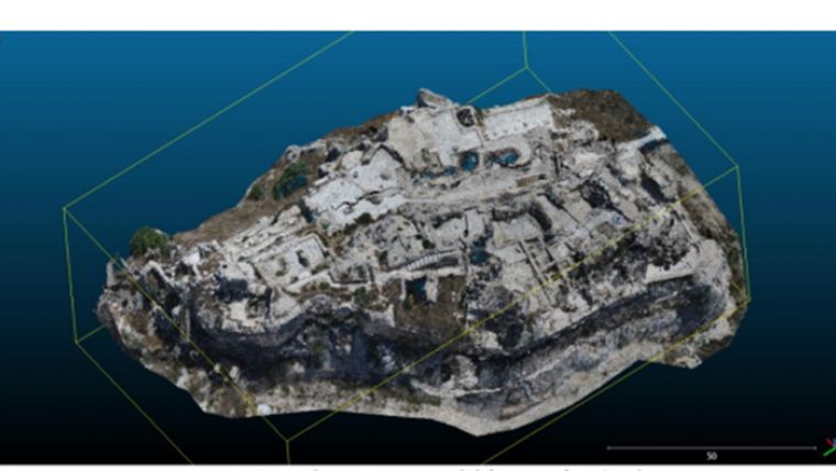
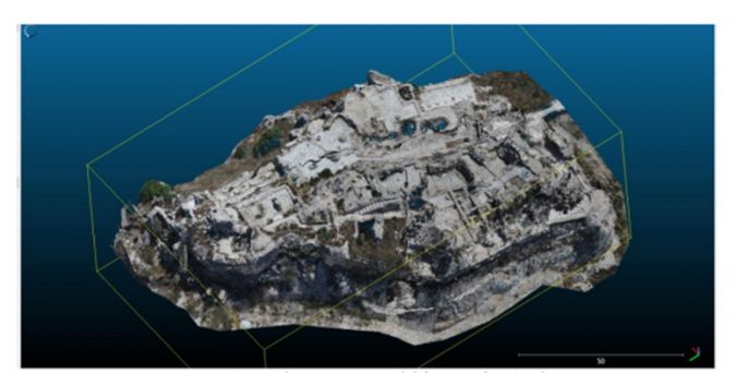
Smart surveying techniques such as laser scanning ayield very significant results, as can be seen in the image below showing the Beaufort Castle by Abboud et al. (Ref). It should be noted that besides laser scanning, also dense matching of images (Ref) and Multibeam Sonar in water (Ref) are important survey techniques to obtain point clouds. Point clouds are produced and used for classification and spatio-temporal monitoring of artificial and natural objects (Ref), used in monitoring in Engineering Surveying (Ref), in detecting individual Trees in Urban Areas (Ref), and also in a Land Registry System (Ref).
Effective Land Administration
The Framework for Effective Land Administration (FELA) has been developed by the United Nations Expert Group on Land Administration and Management, an Expert Group established by the UN Committee of Experts on Global Geospatial Information Management (UN-GGIM) (Ref), (Ref). Land is a sensitive topic that may be a reason for various conflicts between communities and stakeholders (Ref). The complex interrelation between land rights and other sectors requires good policy, guidelines in alignment with the development goals. The Voluntary Guidelines on the Responsible Governance of Tenure of Land, Fisheries and Forests in the Context of National Food Security (VGGT) is one of those guidelines, aiming for collaboration between professionals and universities and with that strengthen the role of surveyors to help address land degradation, soil erosion, and desertification. The impact of international standardization is further growing, esp. ISO 19152:2012, Land Administration Domain Model (LADM) (Ref) is used in a wide range of settings, from the Smart Village Development in Indonesia (Ref) to the Multipurpose Cadastre in Colombia (Ref).
Sustainability and surveying
The Sustainable Development Goals (SDGs) force different management and highlight its role to contribute to and achieve these. At least eight of the 17 Sustainable Development Goals are directly related to land development (Ref). Sustainability is also important for water management. Not only a rising water level asks for a better and more sustainable way of management, but also management that emphasizes the importance of the water quality. The UN Environment Program has calculated that each year more than 8 million tons of plastic ends up in the oceans, causing an intolerable problem that needs immediate and far-reaching action to remedy (Ref).
Smart and open approaches
Multiple sessions used the term ‘smart city’ to describe a technological advanced and sustainable city (Ref), which, as proposed by several authors, results in a resilient and sustainable society (Ref). The success of open data was celebrated too while acknowledging the need for better quality open data (Ref). Further smart city developments range from the use of Augmented Reality Technology in spatial planning (Ref) to the use of Twin Cities, as explained in Grus et al. case study of Zwolle City (Ref). Overall, the main theme was combining a community approach with smart surveying tools to enhance the citizen's perspective.
E-learning
The focus is on “blended learning” and “hybrid learning,” which involves a mix of face-to face (F2F) and online learning (Ref), (Ref), (Ref) to enhance the survey education. The major aim is to prepare the professional surveyors to work in this technologically transformed age taking into account personalized data and global connectivity (Ref), (Ref), (Ref), (Ref). Multiple submissions discuss the developments, achievements, and problems related to blended learning and the establishment of so-called “Professional Learning Communities” in surveying aiming at achieving life-long learning (Ref), (Ref). The shared experience, from the authors, over the last few decades shows that to implement these methods efficiently, long-term investments, and careful design of the learning outcomes is needed (Ref).
Impact of the FIG community
In this brief overview article, highlighting the main Smart Surveyor trends at the FIG Working Week 2020 proceedings. A wide range of technologies and policies have been documented. One thing is certain: the smart surveying technology which is now covered experimentally will play a huge part in achieving the SDG goals within 10 years. This clearly illustrates the importance and obligations of the FIG community to the wider society.

Value staying current with geomatics?
Stay on the map with our expertly curated newsletters.
We provide educational insights, industry updates, and inspiring stories to help you learn, grow, and reach your full potential in your field. Don't miss out - subscribe today and ensure you're always informed, educated, and inspired.
Choose your newsletter(s)


