Strabo Photogrammetry 10.5 Launched
Orbit GeoSpatial Technologies has released its photogrammetric UAS mapping application of Orbit Strabo Photogrammetry 10.5, and the update is immediately available for download. This upgrade adds new features on several levels: from new softcopy tools and a better integration of stereo imagery in GIS to improvements in the UAS data post-processing regarding precision and accuracy.
Peter Bonne, vice-president of Business Development and senior product manager at Orbit GT, said his company is pleased to present the X.5 upgrade to its UAS photogrammetric mapping solution Orbit Strabo. This upgrade has tackled the unexpected: a turnaround in the calculation time of UAS bundle, DTM and Orthocreation to only 10% of the previous version, according to Bonne.
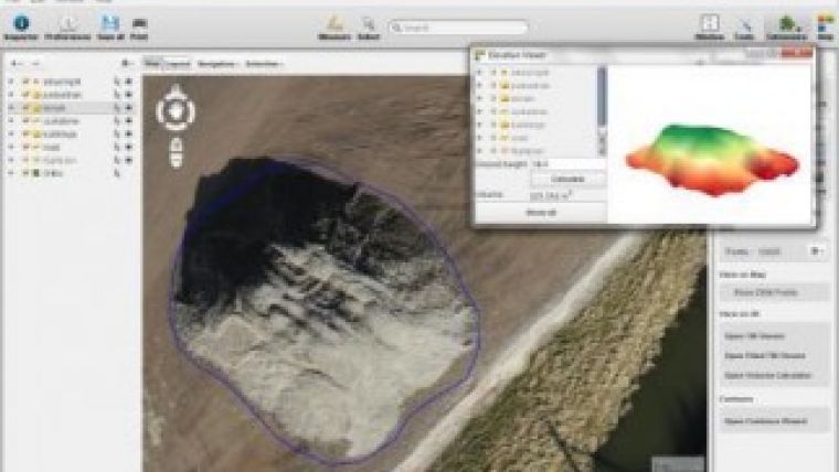
Strabo Full License includes the Strabo Project Manager (compiles the technical data and source imagery and prepares all settings. Images are pre-processed for optimal performance and rotated stereoviews), aerial and terrestrial stereodata importer, the automated Bundle Block Adjustment to process the raw data to fully oriented stereopairs, the GIS integrated Stereo viewing and Softcopy tools to get dynamic and seamless access to all stereopairs, combined with any other GIS layer required in viewing, interpreting or captation, the Stereo Viewing and Softcopy tools, the automated DEM maker which allows the creation of DEMs including break lines resulting in a full high-precision TIN model for volume calculation and 3D rendering, and the automated OrthoMaker tool that orthorecitfies each image according to a given DEM (the standard fencing & merging tools of Orbit GIS allow mosaicing).
Included are also different 3D visualisation techniques and possibility to integrate these data with mobile (laser-scanning) pointclouds in a GIS. Keep in mind that this UAS postflight software supports all standard aerial and terrestrial data.
Download the trial, or update your installation using the website and online documentation. Registered MSC users can upgrade for free.

Value staying current with geomatics?
Stay on the map with our expertly curated newsletters.
We provide educational insights, industry updates, and inspiring stories to help you learn, grow, and reach your full potential in your field. Don't miss out - subscribe today and ensure you're always informed, educated, and inspired.
Choose your newsletter(s)


