StreetMapper GIS
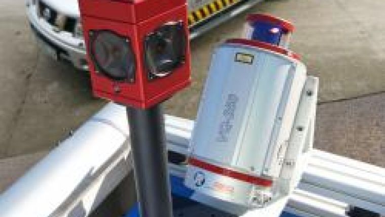
StreetMapper GIS, a new version of the mobile laser mapping system with an integrated panoramic camera, has been launched by 3D Laser Mapping and IGI mbH. StreetMapper GIS is easy to mount on any type of vehicle and offers a cost effective solution for collection of street level asset information for use in geographical information systems (GIS) or other desktop software solutions.
Being offered as an entry-level version of the StreetMapper 360, the system has a single vehicle-mounted laser enabling high precision mapping to a range of 300 metres, a capacity of 300,000 measurements per second and exceptional recorded accuracies. StreetMapper GIS also includes an integrated high-resolution digital camera to capture street level images along the survey route recording features that can be tagged directly to the GIS database.
3D Laser Mapping has also developed a suite of data management software specifically designed to maximise the potential of the StreetMapper GIS. A simple user interface facilitates the display of panoramic images and data can be viewed against a map backdrop, in 3D or as images overlaying surveyed point clouds. With a few clicks of the mouse features can be measured on screen and tagged for use directly in a linked GIS database. Attributes can also be extracted in a GIS ready form (ESRI Shapefile or ASCII) and existing GIS databases can be imported and viewed together with the captured data.

Value staying current with geomatics?
Stay on the map with our expertly curated newsletters.
We provide educational insights, industry updates, and inspiring stories to help you learn, grow, and reach your full potential in your field. Don't miss out - subscribe today and ensure you're always informed, educated, and inspired.
Choose your newsletter(s)


