Surveying the Past Using a Drone
Modelling the Caesar’s Camp Oppidum under Dense Cover
Due to the dense tree cover, Lidar was used in a drone survey of the Caesar’s Camp site, an ‘oppidum’ (fortified habitat) in France dating from around 100 BC.
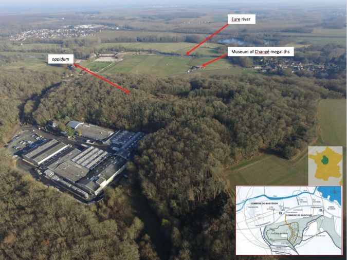
Archaeology has long been reliant on ground-level geophysical disciplines and aerial photographs shot from an aircraft or ultralight. Airborne observations not only enable remains that are invisible on the ground to be detected and studied in a non-destructive way, but also to pinpoint where reconnaissance probes or excavations should be performed. If a site is covered by dense vegetation, Lidar is the only tool practicable for aerial observation. Lidar was applied in a unmanned aerial system (UAS or ‘drone’) survey of the site known as ‘Caesar’s Camp’, situated in the French municipality of Changé/Saint-Piat, located 2km south of Maintenon.
The Caesar’s Camp site is an ‘oppidum’ (Figure 1), which is an archaeological term for a fortified habitat (elevated or in the plain) found in Europe around 100 B.C. Julius Caesar mentions the murus gallicus in the Gallic wars, constructed from earth, wood and stones and possibly reinforced by a huge, massive rampart, preceded by a moat, as at Châteaumeillant in the Cher.
Geographically, the site is a plateau forming a natural promontory of 5.5 hectares, rising on a relatively steep slope of some 40 metres above the Eure valley to the east, and a small dry river to the west and the north. The strategically advantageous position was strengthened by the construction of a 7m-high and 250m-long rampart to the south, erected using the materials excavated on the spot, leaving a 6m-deep trench outside the system. The oppidum overlooks Neolithic to Merovingian burial places which were the subject of research and excavations from 1924 to 1927 and from 1983 to 2000. Partial topographic surveys and observations were carried out by excavation teams in 1980 but the site was abandoned due to lack of funding. Since the 1980s, bibliographic research, land acquisition and management of the site have been done by Comité Archéologique d’Eure-et-Loir (CAEL) whose motto is ‘Publicise to better protect’.
One of the key issues is the age-dating of the oppidum. A few Roman objects have been found, which are probably why the site got the name ‘Caesar’s Camp’. The site was possibly in use in Celtic times, or by the people who installed the Neolithic burial zone. The oppidum at Changé could date back to anywhere from the middle Neolithic period up to the Iron Age and its origins could make it much older than other oppida. It may have been modified over subsequent centuries.
Survey system
A thorough topographical survey of the site had never been carried out due to the dense tree cover. Only airborne Lidar could be used, and up until recently such surveys were very costly due to the use of a plane or helicopter. CAEL asked AIRd’ECO-drone to carry out a drone-based Lidar survey to obtain a topographic map. A DPS4-Urban, four-engine drone was used, equipped with a Yellowscan (YS) Mapper. This powerful, 2kg, class-1, 905nm laser scanner can survey from a maximum altitude of 100m, with a range resolution of 4cm, a precision of 10cm and a scanner field of view of 100° performing 18,500 measurements per second. The sensor operates independently from the drone and uses an inertial navigation system (INS) based on the SBG Ellipse E and a Septentrio AsterX-m RTK GNSS with its own base station. The total weight of the drone including all equipment is 5.2kg. Since the batteries are the limiting factor, a compromise was sought between weight and power to allow 15 minutes of flight.
Data Collection and Processing
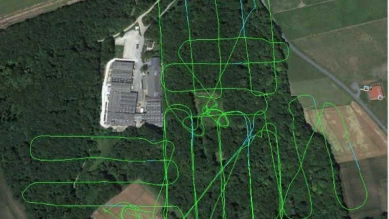
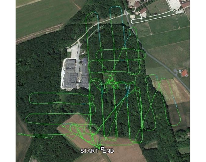
Five flights were performed covering 10 hectares on 14 and 15 December 2016 when there was minimal vegetation cover. The survey was performed in two half days as the number of daylight hours were limited and the temperatures were too low to fly safely in the morning. The RTK base station was placed in a clearing on the plateau. The flights were conducted at an altitude of 50m, a speed of 4m/s and an overlap of 50% (Figure 2), corresponding to a 50m spacing between the tracks. The mean density was 140 points/m2 spread out according to the density of the vegetation.
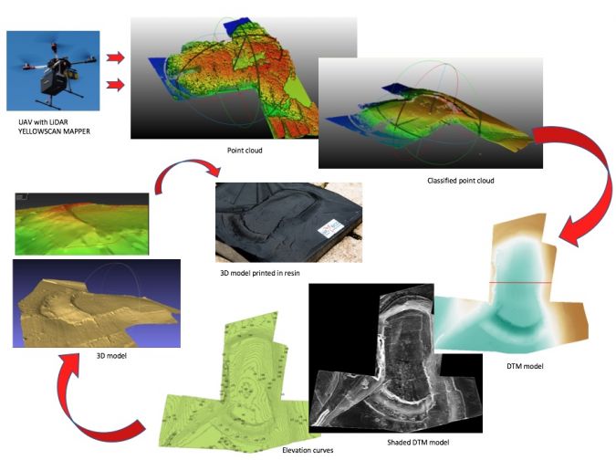
Immediately after the flight, data was retrieved from the drone and visualised in the field using the YS plug-in in QGIS. Newer versions make it possible to instantly view the point cloud while the drone is flying. The visualisation not only allows both verification and adjustment of the next flight, but is also a powerful tool for teaching the uninitiated.
Once the flight levels had been adjusted using Terrascan, the post-processing chain was ’classical’ (Figure 3): classification of the point cloud, processing of the digital terrain model (DTM) in QGIS and creating contour lines, modelling and orthophoto realisation in 3D Reshaper. The 3D model was digitally represented as a shaded relief map in Google Earth. The mean density of the points conserved after classification was 25 points/m2. The measurements were considered to have a precision of between 5 and 15cm and an averaged DTM was computed with an estimated precision of 20cm (1√ point/m2). When compared to a profile taken in a topographical field survey carried out in 1980, the results were found to coincide well. The final processing consisted of creating a ‘real’ model in resin.
Archaeological Results
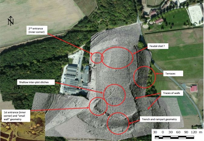
Based on the processing products, a number of features were of interest to the archaeologists (Figure 4). The curvature of the ramp, and that of the trench that borders it, had been believed to be more linear. In particular, two inner corners could be observed at the western extremities. This positive relief towards the interior suggests that they were the entrances to the oppidum. The southern entrance was probably framed by two inner corners, of which the second one on the western side is masked by an excavation with sharp edges, oriented along a small NE-SW dried-up valley which certainly dates to the period of the construction of the Maintenon aqueduct (17th century). The archaeologists discovered remains of this second inner corner on the western side of the present-day access pathway. The geometry of the trench was established using profiles along the full length of the rampart extracted from the DTM.
In the southern portion of the eastern slope, traces of a low wall run perpendicularly down the slope towards the Eure valley. The DTM also clearly reveals ‘steps’ or terraces stretching some 15 metres, with a regularity that is not visible in the field. It is supposed that these terraces are related to the cultivation of grapes, also shown on an old postcard. On the northern edge of the plateau a slightly elevated rectangle is observable which is also shown on a chart from 1859; archaeologists propose this is a feudal clod. In the plateau’s centre, intersecting ‘lines’ are visible which coincide with the modern-day plot map and may correspond to shallow inter-plot ditches.
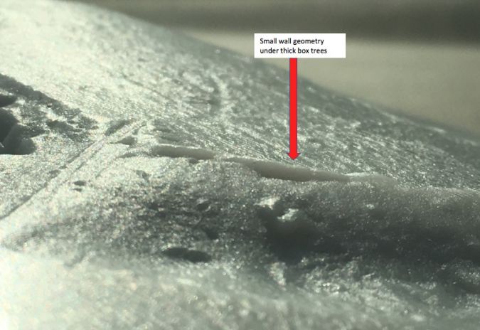
One of the requests was to obtain, insofar as possible, the micro-topography of a seemingly unfinished low wall on the western part of the rampart. This zone is overgrown with very thick Buxus bushes, allowing little if any daylight to penetrate. However, the Mapper was powerful enough to record a sufficient number of points to reconstruct this low wall (Figure 5). The altitude atop this small wall was the same as that of the top of the rampart in its mid-section, and the current hypothesis is that the low wall might have been used as a construction guide for the rampart.
Conclusion
This project proves UAS-based Lidar’s effectiveness for a mapping and archaeology application in the case of dense vegetation cover. Over and above the topographical map, it was possible to obtain precise data of the foreseen morphological elements such as the rampart and ditch as well as the discovery of virtually invisible morphological elements such as the entrances and terraces. These visualisations enable the team of archaeologists to be actively involved in the survey. They also allow, in a second phase, communication to the public. A video is currently being finalised integrating pictures from the ground and the drone as well as a visual with a camera travelling in the 3D model as if flying on-board the drone. Based on this success, other Lidar surveys of wholly or partially covered archaeological sites are scheduled for autumn and winter using even higher-performance Lidar systems (e.g. the YS Surveyor) on a more powerful hexacopter (DPS6-BL) authorised to fly in populated zones.
Acknowledgements
Besides to CAEL, the authors are grateful to the Comité d’Étude, de Documentation et de Sauvegarde de la Nature à Maintenon (CEDSN), the Association pour la valorisation du patrimoine de Saint-Piat et Mévoisins, the Association en Région Centre pour l’Histoire et l’Archéologie (ARCHEA), and the Conseil Départemental d’Eure-et-Loir for their participation and funding. They also thank Jody Mohammadioun for the translation of this article.
Further Reading
- Museum of the Changé megaliths discoveries: megalithesdechange.fr
- Fatima De Castro and Dominique Jagu, 2014: Le Camp de César de Changé, commune de Saint-Piat.1989-2014, 25 ans d’activités. CAEL.
- Dominique Jagu, Bernard Blum and Jean-Marc Mourain, 1998: Dolmens et menhirs de Changé à Saint-Piat (Eure-et-Loir), témoins archéologiques des rites et pratiques funéraires des premiers agriculteurs beaucerons. ARCHEA.
- Isabelle Heitz and Dominique Jagu, 2017: Modélisation d’un oppidum sous couvert végétal dense, en Eure-et-Loir, par un LiDAR aéroporté par drone. Revue XYZ 153, pp.45-50

Value staying current with geomatics?
Stay on the map with our expertly curated newsletters.
We provide educational insights, industry updates, and inspiring stories to help you learn, grow, and reach your full potential in your field. Don't miss out - subscribe today and ensure you're always informed, educated, and inspired.
Choose your newsletter(s)


