TanDEM-X Radar Satellite Deployed
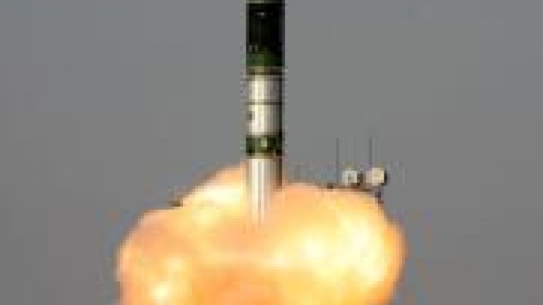
The TanDEM-X radar satellite designed and built by Astrium (Germany) was successfully launched early this morning. At 04:14 hours CEST (08:14 hours local time), a Russian Dnepr launch vehicle carrying the huge satellite, which has a launch mass of more than 1.3 metric tons and measures five metres in length, lifted off from the Baikonur Cosmodrome in Kazakhstan. Around ten minutes later, the satellite separated from the launch vehicl e's upper stage. The first signals from the satellite were received by the "Troll" ground station in Antarctica at 04.15 hours.
TanDEM-X will operate in tandem with its almost identical twin, the TerraSAR-X satellite that became operational in 2007. Together, the satellites will survey the entire surface of the Earth from an altitude of 514 kilometres. They will pass over each region many times, gathering data with which to construct an elevation model of the globe - covering no less than 150 million square kilometres.
"After this auspicious start to the mission, the new project to map our planet in three dimensions can finally begin," said Astrium Satellites CEO Evert Dudok. "With the two Astrium-built satellites flying in formation, it will be possible to produce a digital elevation model of the Earth to an accuracy of better than two metres. This level of quality has never been achieved before."
The success of TanDEM-X is a reflection of Astrium's expertise in satellite-based radar technology and will add to the company's competitive strength, also in the field of geoinformation services.
The total estimated cost of the TanDEM-X mission amounts to EUR165 million. Of this amount, the DLR will contribute EUR125 million, while the European space company Astrium will provide the remaining EUR40 million from its own resources. The TanDEM-X mission is being implemented and jointly financed by the German Aerospace Centre (DLR) and Astrium GmbH under the terms of a public-private partnership (PPP) agreement and with the support of the German Federal Ministry of Economics and Technology (BMWi).
Astrium subsidiary Infoterra GmbH is responsible for the commercial marketing of the TanDEM-X elevation model.

Value staying current with geomatics?
Stay on the map with our expertly curated newsletters.
We provide educational insights, industry updates, and inspiring stories to help you learn, grow, and reach your full potential in your field. Don't miss out - subscribe today and ensure you're always informed, educated, and inspired.
Choose your newsletter(s)


