Testing Aerial Digital Cameras
Accuracy, Radiometry, Sharpness and Storage
Aerial imaging for mapping purposes is increasingly done using digital cameras. The introduction of new models brings a steady rise in pixel volume, enabling wider swath width and thus reductions in flight line, flight costs and project risks, or data acquisition with larger ground-sample distances (GSD), preserving efficiency. Full exploitation of larger GSD depends on geometrical accuracy, dynamic range, image sharpness and storage device. The author tested these four features of two UltraCam systems: the Xp and L.
Vexel Imaging introduced the UltraCamX in 2006, preceded by the UltraCamD in 2003. Today the large-format models are the UltraCamXp (2.9cm GSD at 500m flying height) and UltraCamXp Wide-Angle (4.3cm GSD at 500m flying height), both with image array size 17,310 x 11,310. The UltraCamL, panchromatic array size 9,735 x 6,588 (colour and NIR: 5,320 x 3,600), is a medium-format camera, while its recently introduced successor, the UltraCamLp, is a large medium-format camera with array size 11,704 x 7,920 and 4.3cm GSD at 500m flying height. For various array sizes and GSDs, the geometrical accuracy of today's UltraCam systems is better than two micrometres.
Critical Components
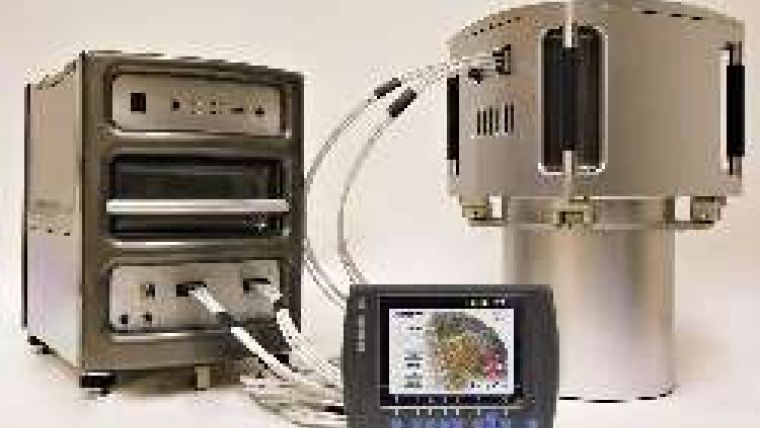
The Xp and L systems tested (see Figure 1) are installed and integrated with Global Navigation Satellite System (GNSS) and Inertial Measurement Unit (IMU). GNSS measures x, y and z (easting, northing and height), and IMU measures roll, pitch and yaw (omega, phi and kappa); these six parameters relate image to map. Given known stable characteristics of the digital camera, understanding of the relationship between IMU and camera axes greatly reduces the need for ground control to achieve high accuracy maps. Two components tie the IMU to the camera:
-offset vector between IMU centre and camera projection centre
-rotation matrix from IMU body frame to optical axis of camera.
These components are determined by boresight calibration. Especially critical is good calibration of the rotation component, because angular error increases in proportion to flying height.
The INS and camera mount must be rigid enough to resist flex and rotation so that the values of these components, once determined through calibration, may be used over multiple flights.
Systems and Coverage
The Xp was installed and integrated with a Span-SE, the latest GNSS/IMU system from Novatel, based on the company's OEMV GPS-Glonass receiver. Span-SE offers a wide range of accuracy levels for airborne and mobile mapping. There are many different brands of IMU. We chose the LN200 IMU for our system, allowing much tighter turns in the air and thus saving time and fuel without compromising accuracy. The L was installed and integrated with a Novatel Span, with FSAS IMU. The Xp was flown over an area in Georgia, USA; coverage comprised 44 overlapping photos in four flight lines. The L was flown over an area in New Mexico, USA; coverage comprised ten overlapping photos in four flight lines. Both terrains are flat, so no digital elevation models were used to initialise tie-point matching. The software used was Match-AT from Inpho.
Geometrical Accuracy
The root-mean-square error (RMSE) of tie-point matching results was used as accuracy measure. For the L, the RMSE was 0.9micrometre for pixel size 7micrometre; well within the two-micrometre specification, demonstrating the mapping capability of the system. For the Xp the RMSE was 1.9 micrometre, significantly less than one-third of the six-micrometre pixel size and within the two-micrometre specification. However, the Georgia site was covered by dense forest and captured in the presence of thunder clouds, resulting in very high contrast between strips. Significantly better results have been achieved by others under better weather and light conditions. In summary, the geometrical accuracy of the UltraCam family meets or exceeds technical specification.
Dynamic Range
The poor weather and light conditions in Georgia during image capture showed up in the Xp images as very bright areas and dark shadows. Nevertheless, ground points could be located and measured without local image adjustments. The dynamic range of the Xp images was almost 13bits (or 7,600 grey values) which is the same as for the UltraCamX; although one might have expected a difference due to the smaller pixel size of the Xp (6 rather than 7.2micrometre).
However, the specifications of the Xp image array show an improved signal-to-noise ratio which allows retention of the dynamic range. Figure 3 demonstrates the content of Xp images present in shadowed areas. Because of the high radiometric range, details are well visible in shadow areas, enabling full tie-point matching and ground-control measurements. Images taken under unfavourable light conditions demonstrate comparable features for the UltraCamL (Figure 4).
Image Sharpness
Image sharpness appears stable across the image; no reduction of sharpness from image centres towards corners could be detected during visual inspection (Figures 5 & 6). However, image quality in general depends on proper setting of the aperture; the Xp is more sensitive than the L, possibly due to the latter's smaller pixel size.
The manufacturer addresses this issue by showing the preferred aperture settings on the operator display, highlighting bad settings.
Storage Device
The large GSD capabilities of the cameras require storage devices big enough to avoid continuous exchange of data units during flight. Portability, robustness and stability are other important criteria. The Xp hard drive has a capacity of 4.2TB, that is 6,600 images, each of 196 megapixels; sufficient for a long flight day. In-flight exchange of data units will probably not be required, but is possible and provides unlimited storage. The solid-state storage device of the L is fully integrated into the sensor head. Up to 3,600 images can be stored and the data unit exchanged during flight. Both the hard drive of the Xp and the solid-state data unit of the L include a docking station for easy download to the data-processing centre. When fully loaded, Xp data download requires three to four hours, for the L this is one hour.

Value staying current with geomatics?
Stay on the map with our expertly curated newsletters.
We provide educational insights, industry updates, and inspiring stories to help you learn, grow, and reach your full potential in your field. Don't miss out - subscribe today and ensure you're always informed, educated, and inspired.
Choose your newsletter(s)


