The Expanding Field of 3D City Model Applications
The application space of 3D city models has expanded hand in hand with technical advancements. In addition to the ‘traditional’ use cases in urban planning and zoning, 3D city models are expected to facilitate energy analysis, detailed architectural visualisation, interactive and immersive applications development, and participatory GIS. All this places challenging requirements on 3D city model platforms. The discussion about 3D city models is further complicated by the amount of different platforms used for 3D city model applications. In addition to the professional GIS/CAD tools, 3D city models are used on game engines and various web-based 3D viewers, such as virtual globes. In a recent study, the authors took a closer look at some of the 3D city modelling projects in the six largest cities in Finland.
Reviewing the major 3D city modelling projects in Finland
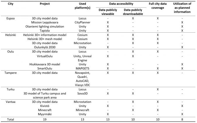
The authors used project descriptions maintained by the cities to obtain an overview of the current activities. To support further understanding, local city representatives in the studied cities were interviewed. A summary of the analysed projects is presented in Table 1.
Excess of platforms
Firstly, the studied 3D city models utilised a great variety of platforms. In the 19 studied projects, a total of 13 different platforms were discovered for hosting the models. These included GIS/CAD software (e.g. Trimble Locus and Bentley Microstation), virtual globes (e.g. Cesium, CityPlanner, Sova3D, MAPGETS) and game engines (e.g. Unity, Unreal Engine). Some of the software solutions applied in Finland were more or less unique and have not seen wide adoption globally.
Secondly, the authors noted that in each studied city the maintenance and upkeep of the 3D city models was tied to the statutory base mapping process that heavily relies on the chosen GIS/CAD software. In many cases, the 3D model data maintained by the city itself was used as an input or reference data for virtual globes and 3D game engine-based projects, which focused on specific applications often aimed at broader audiences.
Data quality and accessibility
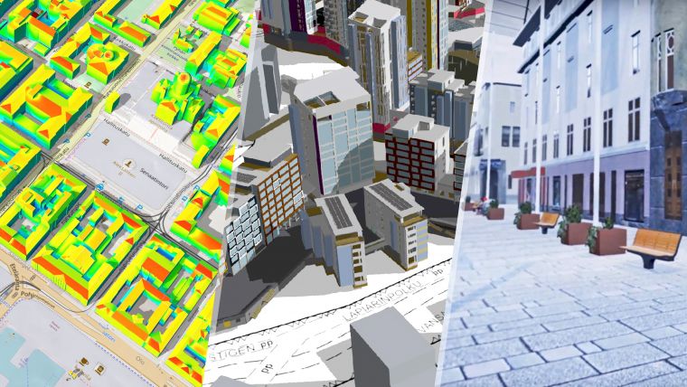
The studied 3D city modelling projects contained a variety of different levels of detail, ranging from simple block models to highly photorealistic models containing facades modelled in great detail. Fewer than half of the models utilised as-planned information such as BIM or architectural plans. More than half of the city models covered the full regional area of the city.
In addition to data quality, accessibility plays a vital role in 3D city modelling, especially when models are to be used as a basis for developing new applications. Almost two-thirds of the studied city models could be freely viewed via a web-based viewer. This was realised either via separate viewer utility or, in the case of virtual globes, natively by the platform itself. More than half of the city models studied were offered for download over the internet. However, none of the cities offered any original raw data such as Lidar point clouds. This hinders possibilities to freely edit the models or to run additional analysis.
Read the full article Characterising Activities in 3D City Modelling to learn more.

Value staying current with geomatics?
Stay on the map with our expertly curated newsletters.
We provide educational insights, industry updates, and inspiring stories to help you learn, grow, and reach your full potential in your field. Don't miss out - subscribe today and ensure you're always informed, educated, and inspired.
Choose your newsletter(s)


