The First-ever Online-only UN-GGIM Session
The Tenth Session of the United Nations Committee of Experts on Global Geospatial Information Management
The United Nations Committee of Experts on Global Geospatial Information Management (UN-GGIM) gathered for its Tenth Session in the shape of three two-hour informal meetings on 26 and 27 August and 4 September, albeit only ‘virtually’. The event was originally scheduled to be held at the United Nations Headquarters in New York, USA, at the beginning of August. When the COVID-19 restrictions made it impossible for delegates to travel, the session was postponed and rescheduled. Thanks to all the IT preparations made by the Secretariat, the Tenth Session successfully became the organization’s first-ever online-only session.
The Committee of Experts actually had their first successful experience of a virtual meeting in the run-up to the Tenth Session, when the Sixth High Level Forum on UN-GGIM was forced to switch to an online format in May and June after becoming a victim of the air travel restrictions in April. The High Level Forum, organized by Ordnance Survey of Great Britain, hosted 900 unique participants from 100 Member States. The Tenth Session of UN-GGIM, which was attended by around 600 participants from more than 90 Member States and observer organizations, was co-chaired by Ms Ingrid Vanden Berghe of the National Geographic Institute, Kingdom of Belgium, Mr Fernand Guy Isseri of the National Institute of Cartography, Cameroon, and Ms Rosamond Bing of the Ministry of Lands and Natural Resources, Kingdom of Toga, and was supported by the Secretariat.
COVID-19 pandemic response
The reason for holding the session as an online-only event rather than getting together in New York was, of course, the COVID-19 pandemic. It was because of the same pandemic that the Secretariat, together with the regional commissions and committees, had already started to communicate the broader geospatial response to the crisis. This crisis highlights the critical need and value of geospatial information. Therefore, suggestions to continue working in response to the crisis, to share experiences, to analyse where demographic and health data could be improved and to help mobilize financial resources to strengthen national geospatial information were all wholeheartedly supported. The Integrated Geospatial Information Framework (IGIF), the Global Statistical Geospatial Framework (GSGF) and the Strategic Framework on Geospatial Information and Services for Disasters are all outcomes of the Committee’s work over the last ten years and are now proving helpful in the response to the crisis.
Future trends
One of the first and most important decisions of the Committee at the Tenth Session was the adoption of the third edition of the report on ‘Future Trends in Geospatial Information Management’. This five-to-ten year vision is developed through broad global consultation under the guidance and leadership of Ordnance Survey of Great Britain, which held a consultation round earlier this year to shape the new edition. The Future Trends report has been a living document for a number of years and remains a valuable resource for highlighting the importance of geospatial information as it reflects on a wide set of emerging and developing trends which can be deployed by Member States to increase the use of geospatial information for societal, technological and economic welfare. However, the Committee pointed out the danger of a widening geospatial digital divide and therefore expressed its support for national geospatial information capacity-building in developing countries. It noted at the same time that extra budget is needed for this purpose, which might be collected through several funding options.
Integrated Geospatial Information Framework
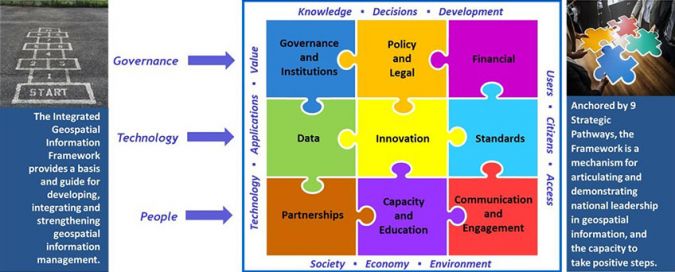
The Integrated Geospatial Information Framework (IGIF) has an important place on the agenda of every session of the Committee of Experts. It will provide a basis and guideline for developing, integrating, strengthening and maximizing geospatial information management and related resources in all countries. It will assist countries in bridging the geospatial digital divide, securing socio-economic prosperity and leaving no one behind.
The IGIF comprises three parts as separate, but connected, documents. Part 1 is an Overarching Strategic Framework, Part 2 is an Implementation Guide, and Part 3 is a Country-level Action Plan. The three parts make up a comprehensive IGIF that serves a country’s needs in addressing economic, social and environmental factors which depend on location information in a continually changing world. The Implementation Guide communicates to the user what is needed to establish, implement, strengthen, improve and/or maintain a national geospatial information management system and capability.
The IGIF focuses on location information that is integrated with any other meaningful data to solve societal and environmental problems and to understand and take benefit from a nation’s development priorities and the Sustainable Development Goals. As such, it acts as a catalyst for economic growth and opportunity.
In the months prior to the Tenth Session, participants from 130 Member States worked in consultation meetings and workshops to come up with a draft Implementation Guide. That will now go into consultation again for further refinement. To steer this refinement, a group of experts with a balance of geographic representation and expertise was appointed. Meanwhile, Country-level Action Plans are developed on country level around the globe.
Global Geodetic Centre of Excellence
Germany offered to establish and host a Global Geodetic Centre of Excellence at the UN Campus in Bonn, Germany. This will be the first centre that will coordinate global alignment and cooperation across Member States and stakeholders to strengthen geodetic infrastructure. The new Centre of Excellence will be supported with communication resources from Norway and organizations such as the International Association of Geodesy (IAG) and the International Federation of Surveyors (FIG), together with other geodetic stakeholders.
Land administration and management
Thanks to progress on the Framework for Effective Land Management, after finalization the framework will serve as a possible reference for Member States when developing, reforming, strengthening and modernizing effective and efficient land administration processes and systems. The Committee of Experts requested that the framework should include and specifically address the rights of indigenous peoples to lands, territories and resources which they have traditionally owned, occupied or otherwise used or acquired. The COVID-19 pandemic has demonstrated a clear need for effective and reliable land information to make it possible for governments to respond as efficiently as possible.

Marine Geospatial Information
The Working Group on Marine Geospatial Information prepared a report of its activities for the Committee. The Working Group is busy implementing the Integrated Geospatial Information Framework within the marine domain. It was also encouraged to strengthen collaboration with the International Hydrographic Organization (IHO) and seek other partners in ocean sciences and observations. In particular, the UN Decade of Ocean Science for Sustainable Development, the General Bathymetric Chart of the Oceans (GEBCO), the Seabed 2030 Project and the Innovation and Technology Laboratory of the IHO in Singapore will be helpful in sharing, integrating and fostering interoperability of terrestrial and marine geospatial information.
Future sessions
The 11th Session of UN-GGIM will be held in New York from 4-6 August 2021. The Second United Nations World Geospatial Information Congress is due to be held in 2022, in a location to be announced at a later date.

Value staying current with geomatics?
Stay on the map with our expertly curated newsletters.
We provide educational insights, industry updates, and inspiring stories to help you learn, grow, and reach your full potential in your field. Don't miss out - subscribe today and ensure you're always informed, educated, and inspired.
Choose your newsletter(s)


