The Role of GIS Technologies in Dengue Fever Control and Prevention
Controlling and preventing infectious diseases like dengue fever is one of the main issues for public health authorities in many countries. GIS technologies can play a key role to support decision-makers in expanding their vision of action, taking in efficient strengthening control and prevention.
Dengue fever is widely found across the world, especially between the latitudes of 35° North and 35° South below an elevation of 1,000 metres. The main transmissions, Aedes mosquitoes, usually live in a warm and wet environment. Therefore, researchers can compare with different factors, such as elevation, temperature, humidity, population density and periods, and visualise them on maps to better understand the infection.
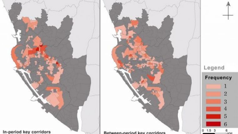
By establishing an ecological network, researchers can identify the inhabitation of infected mosquitoes and computes the possible moving routes. Also, the analysis tools of SuperGIS Desktop will enable the users to overlay the networks, so that the same and different periods of transmission spread can be viewed clearly on the map for following applications.
With GIS technologies, the officials in the Centre of Disease Control can overlay diverse map layers, which contain different factors for further analysis, as well as produce proper thematic maps, to predict the most possible spread directions and control potential risks. On the other hand, the cured or controlled areas can be shown on maps too, helping officials understand the situation and effectiveness for timely adjustment.
The research considers both time and space factors, and utilises SuperGIS Desktop to support the analysis in a geospatial way. With GIS technologies, officers can prevent the disease not only by killing mosquitoes in known locations, but also by predicting the potential hotspots in order to take action in advance.
Learn more about the case here.

Value staying current with geomatics?
Stay on the map with our expertly curated newsletters.
We provide educational insights, industry updates, and inspiring stories to help you learn, grow, and reach your full potential in your field. Don't miss out - subscribe today and ensure you're always informed, educated, and inspired.
Choose your newsletter(s)


