The Power of the Social Tenure Domain Model
A Flexible Low-cost Solution for Recording Land Rights
High-end technology-driven solutions often create serious implementation constraints in land administration. Furthermore, despite the developments and advances in geo-ICT, there is still a gap in the development of tools that model people-to-land relationships independently from the legality of those relationships. This article explains why the Social Tenure Domain Model (STDM) is a powerful and effective land information system to arrive at locally engineered solutions for improving tenure security.
While land administration plays a crucial macroeconomic role in the collection, management and dissemination of information about land tenure rights, land use and value, high-end technology-driven solutions often create serious implementation constraints where issues such as those related to licence costs of proprietary software have been reported to land administration programmes. In addition, despite the developments and advances in geo-ICT, there still exists a gap in the development of tools that model people-to-land relationships independently from the level of formalisation, or legality, of these relationships. The Social Tenure Domain Model (STDM) was designed to specifically address these challenges.
Participatory
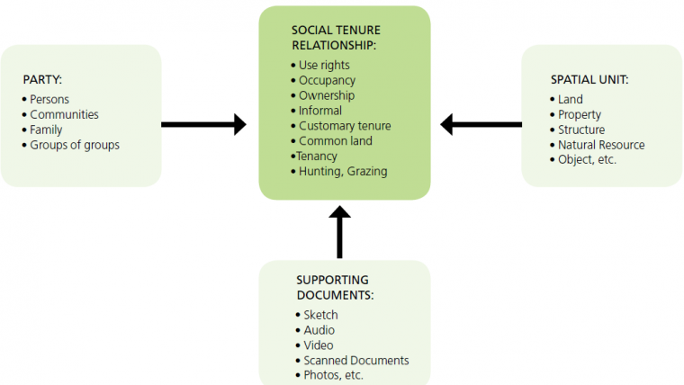
The STDM is a pro-poor, participatory, flexible and affordable land tool for representing people-to-land relationships along the ‘continuum of land rights’, independently of the level of formalisation and legality of those relationships. The basic way of defining any form of land right represented through the STDM is that a party has a social tenure relationship with a spatial unit supported by evidence-based source documents (Figure 1), and this also applies to related restrictions and responsibilities. A party can be a person, household or a cooperative society, whereas a parcel, informal structure, natural resources or building can be used to represent a spatial unit. The STDM is an initiative of the Global Land Tool Network (GLTN) in collaboration with its partners to support pro-poor land administration.
Its practical implementation involves participatory enumeration – a survey method which aims to gain better knowledge of the needs and priorities of a community through the administration of appropriate data collection tools. The STDM offers a practical way to address land administration problems related to recognising and recording land rights on the continuum.
STDM Tool
The STDM tool is a desktop-based application which is designed to fully comply with the conceptual model in Figure 1. It brings together mature and stable open-source software projects through a consistent, easy-to-use interface, which allows non-specialised users to define and manage tenure information, visualise spatial units as well as support the creation of reports.
Customisation of Tenure Context
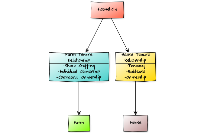
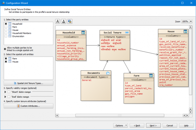
The STDM tool provides a data management interface for designing tables and corresponding attributes to meet the data requirements of different application contexts. The current release, version 1.7, enables the definition of compound tenure relationships such as different party types having tenure relationships with a given spatial unit type, or a party type having separate tenure relationships with different spatial units – e.g. a household having different sets of tenure relations with a house and farm respectively (Figure 2). Figure 3 shows this implementation in the STDM tool.
By default, every tenure relation between a party and spatial unit includes a percentage share of the right as well as information on start and end dates representing the duration for which the relation is valid. In addition, custom tenure-specific attributes, such as the identification number of tenure supporting documents, can be defined depending on the tenure context.
Data Management
All the spatial and attribute information in the STDM is stored in a PostgreSQL/PostGIS database, with the user interface hosted as a QGIS extension, also known as a plug-in. The use of PostgreSQL and PostGIS software components enables the STDM to be deployed as a stand-alone installation or in a client-server environment. The former is mostly applicable in those areas where internet infrastructure does not exist or might be too costly to set up for the given programme, such as in urban informal settlements or rural areas.
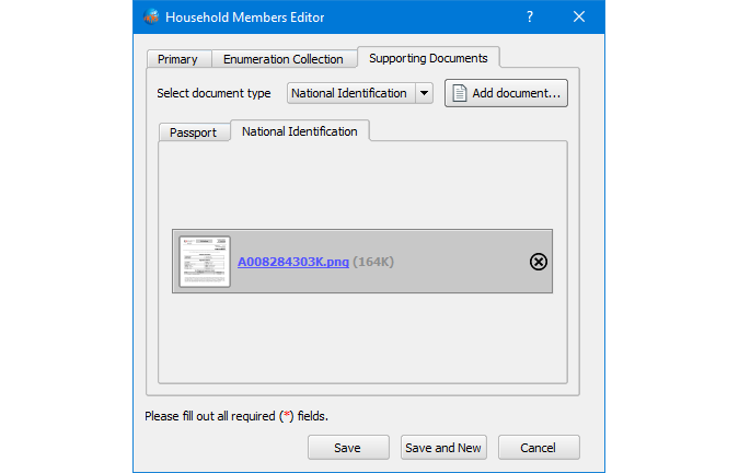
Evidence-based Supporting Documents
The STDM provides an intuitive interface which enables the attachment of supporting documents for every record stored in the data repository (Figure 4). These documents provide proof or support claims within the given context. Such evidence from the field can be photographs or scanned documents which are subsequently uploaded into the software when defining the primary textual information. Examples of these can be photos of people or households, scanned copies of utility bills or even hand-written tenancy agreements in urban informal settlements.
The types of source documents that are applicable for each entity can be specified using the data management interface during the initial stage of defining the structure of the data profile.
Extension by Developers
The STDM is designed to be a flexible platform which enables software developers to extend, modify or integrate with existing enterprise systems in order to meet the functional requirements of their own applications. Its application programming interface (API) provides various extensibility points from definition of custom data types, data storage back ends, widgets for data types, document management back ends and data importation formatting to report design items and production.
The STDM is written in Python programming language and the developer community can participate in the open-source project on GitHub.
The Implementation Process
The application of the STDM promotes inclusiveness and continuous capacity development amongst all key stakeholders, from the initial inception up to the deployment and rollout stages. At the core of the implementation is the active participation of the local community leaders and members, who must be continuously engaged throughout the whole process.
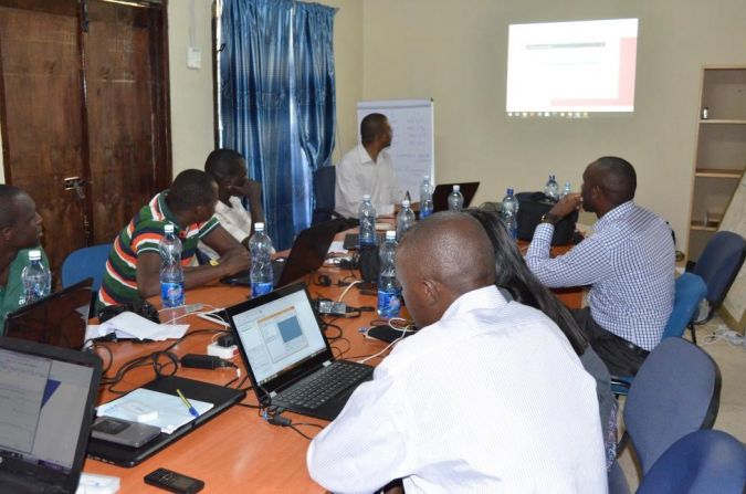
The key activities include planning and consultations amongst the stakeholders where key issues pertaining to tenure security are discussed; this process also includes identifying the main areas where GLTN tools (i.e. continuum of land rights approach, gender evaluation criteria, STDM, participatory enumerations) can be applied. An implementation plan is developed which incorporates agreement on the roles and responsibilities of the different stakeholders (Figure 5). This is followed by an extensive mobilisation and sensitisation process which involves local government authorities as well as community leaders and members.
Data collection
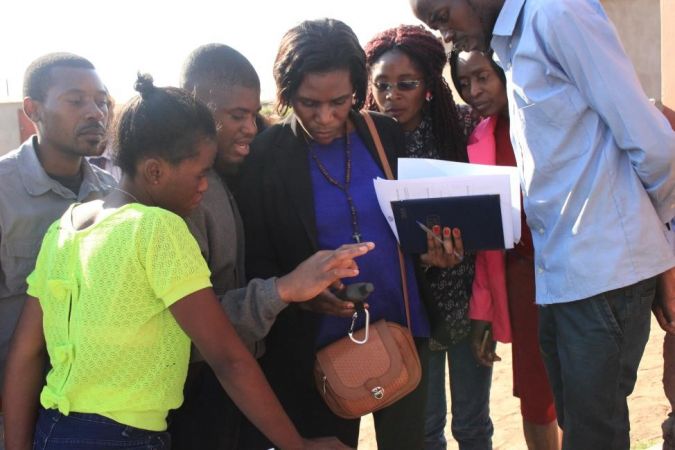
The data requirements of the project are identified and customised in the STDM to fit the local context. This is an iterative process which is considered final once all the stakeholders have reached agreement on the data attribution to be captured, using either digital or paper-based surveys. Data collection involves conducting interviews and plot or structure mapping, and the enumeration teams are usually accompanied by local leaders and local government officials. The mapping can be done using handheld GPS receivers (Figure 6) and/or high-resolution satellite images depending on the context. All the collected data, documents and photographs are entered into the STDM tool. In some instances, the initial digital maps are also updated at this stage. The enumerators are also trained to analyse the data and produce reports using the tool.
In the final stage, community members validate the collected data before it is subsequently updated in the STDM database. This validation process is critical as it improves the credibility of the overall process. Afterwards, the community members and local government officials agree on modalities of how to continue updating the data and sustaining the process, with backstopping provided by GLTN. Manuals, guidelines and process documents are produced, and translated if applicable, as part of standard outputs from these interventions.
Moving Forward
As the STDM continues to evolve technically based on the convergence of new technologies with emerging country needs, GLTN is exploring new opportunities based on the strategic guidance provided by the STDM Advisory Committee. Examples of such opportunities include: establishing data-sharing mechanisms from community level to national level in line with fit-for-purpose principles of ‘incremental upgrading’; developing a sustainable business model; submitting the tool to the OSGeo Incubator programme; promoting the development of Open Geospatial Consortium (OGC) standards related to land administration through the LandAdmin Domain Working Group (DWG) and supporting the implementation of the Sustainable Development Goals (SDGs) – particularly 1, 2, 5 and 11) – in land tenure projects at country level. The use and application of the STDM in these strategic areas of interest will be closely aligned with GLTN’s Phase III strategy which is currently under development.
Concluding Remarks
The capability of the STDM to further incorporate participatory approaches makes it a powerful and effective land information system to arrive at locally engineered solutions for improving tenure security. The uptake of the STDM has in some instances led to inclusion of the STDM-generated information in government initiatives such as the Transforming Settlements of the Urban Poor in Uganda project (TSUPU), establishment of a land information system to manage urban and customary land in Turkana County (Figure 7), and in the Kenya Informal Settlement Improvement Project (KISIP) in Kenya. The STDM is now seen as a significant tool that local governments can adopt for development objectives like inclusive planning, tenure security improvement, provision of basic services and infrastructure. A future article will focus on experiences and lessons learnt from implementations.

Value staying current with geomatics?
Stay on the map with our expertly curated newsletters.
We provide educational insights, industry updates, and inspiring stories to help you learn, grow, and reach your full potential in your field. Don't miss out - subscribe today and ensure you're always informed, educated, and inspired.
Choose your newsletter(s)


