
No statistics could possibly convey the importance of energy to our economies and everyday lives. Nearly everything people interact with on a daily basis has a source of power. Growth in any nation is impossible without massive amounts of energy for development, transportation and agriculture.
(This story is brought to you by European Space Imaging)
We currently sit at the crossroads between fossil fuels, renewables, rapid development and increasing safety and environmental concerns. New tools and techniques are being developed daily to better produce energy as well as efficiently monitor and protect current sources. Analysing tremendous amounts of new and degrading infrastructure requires tremendous amounts of updated reliable data.
With pipeline and electrical corridors stretching across vast expanses of land, city-sized solar farms and supply chains that demand ever-increasing security, Location Intelligence (LI) has become one of the biggest tools in the arsenal of energy companies. There is a strong demand for monitoring energy infrastructure in order to solve the most pressing challenges faced by the energy industry. Near real-time monitoring of both wide areas and specific locations has become crucial to analyse the markets as a whole and react to potentially damaging events.
Very High Resolution (VHR) optical satellite imagery can be an essential tool to monitor critical infrastructure like oil pipelines as it offers recurrent information from both a local and global scale. By combining data sources with artificial intelligence and machine learning, further insights can be gained autonomously and in a timelier manner. Advances in these technologies are becoming more affordable for most users, making the exploitation of remote sensing reliable and profitable.
Other areas whereupon VHR optical satellite imagery can provide benefits include encroachment monitoring, vegetation control, environmental impact, site exploration and energy market evaluations. The following article will give an overview of how the Energy industry can benefit from the use of VHR satellite imagery.
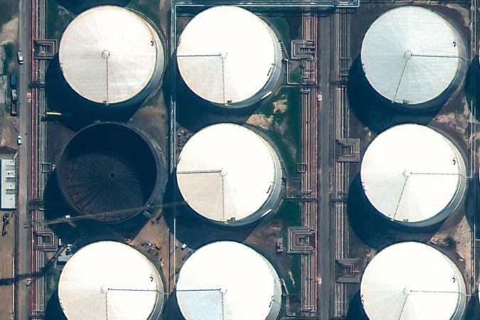
Measuring Oil Inventory
Possibly the only commodity more valuable than oil, is reliable data about oil markets. Satellite imagery can be used to not only map, monitor and track activity at production facilities, but also to measure the actual inventory with an incredible degree of accuracy.
Crude oil is typically stored in large cylindrical vessels with roofs that float on top of the oil. Stereo VHR satellite imagery can be used to determine the height of individual floating roofs, therefore allowing for simple volume calculations to be made. This data has tremendous value in energy market speculation.
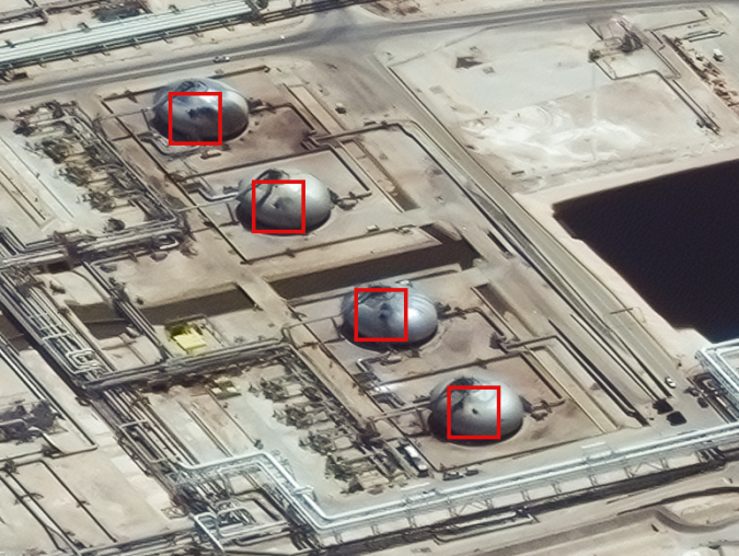
Energy Supply Disruption Crisis Management
On 14 September 2019, two energy infrastructure sites in Saudi Arabia were attacked during an airstrike. It was one of the biggest oil supply disruptions in recent history. However, markets remained relatively stable and rebounded quickly thanks, in large part, to satellite imagery.
Very High Resolution satellite imagery was collected the day after the attack, allowing analysts to examine the damages and validate the claims made by the Saudi Aramco oil company. Over the following weeks, several more images were collected for tracking repair progress and calculating inventory levels.
The level of detail contained in VHR satellite imagery verified that significant portions of the damage were superficial and were able to be easily repaired. Satellite imagery also made it possible to monitor activity at back up oil and gas facilities to ensure uninterrupted supplies. Due to competent crisis management efforts aided by near real-time monitoring with satellite imagery, speculators were able to effectively react to the disruption without overreacting.
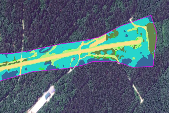
Vegetation Management
Vegetation encroachment, one of the leading logistical challenges facing utilities providers, causes serious power outages and hinders maintenance and emergency repair efforts.
Multispectral stereo VHR satellite imagery allows users to map the height, density and type of plants within power line corridors at significant savings compared to aerial and on-site inspections. As chemical herbicide regulations tighten around Europe, frequent monitoring of problem areas and validation of completed trimming become increasingly necessary.
Protecting Pipelines
Third Party Interference (TPI) continues to be the leading cause of pipeline failures worldwide. Oil and gas pipeline accidents tend to be high-impact events that affect public safety, environmental protection and entire energy markets.
Industry leaders are constantly looking for new and innovative techniques for monitoring pipeline Right of Ways (RoW). Advancements in satellite imagery and artificial intelligence allow asset managers to monitor entire stretches of pipelines from their desk. Very High Resolution satellite imagery is integrated seamlessly into tailored made mapping and advanced detection software so users can monitor changes in the activity and structures near pipeline corridors.
The level of detail that 30 cm resolution satellite imagery provides allows the user to identify and track potential hazards such as heavy construction equipment. This can help to efficiently deploy personnel and resources at much lower costs than aerial and on-site inspections.
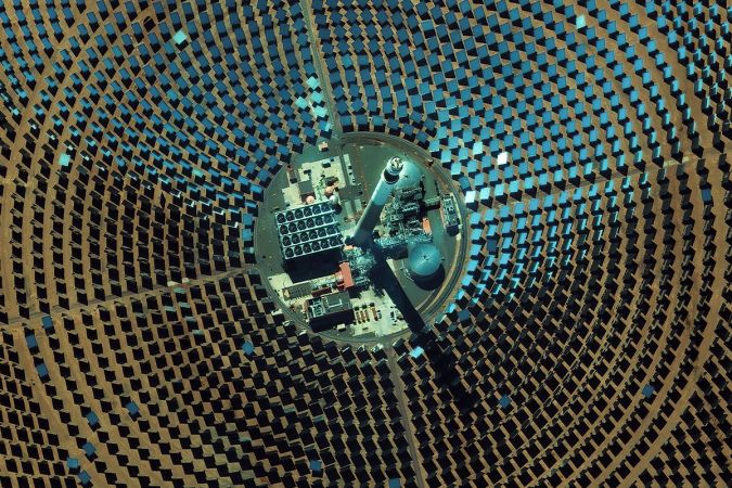
Renewables
It should come as no shock that renewable resources such as solar and wind energy have seen incredible growth. As these technologies have developed and spread, so have the remote sensing techniques to support them.
VHR satellite imagery is being widely used in the solar industry for applications such as monitoring massive, city-sized solar farms and automatic detection of solar panels on houses and buildings. The wind energy industry uses satellite imagery to map water depth and sand bars for offshore farms as well as validating propeller directions from their desktop.
Planning New Energy Infrastructure
The “Paris Agreement” has created the need for expanded renewable energy infrastructure across Europe. The conventional methods of site selection and planning using registry office maps, manual inspections and aerial photos cannot keep up. Cutting edge methods for efficient site selection and planning that utilize satellite imagery in combination with Artificial Intelligence (AI) and big data processing are currently underway.
The German Aerospace Center (DLR) as well as many other Earth observation and data analytics organizations are aiming to develop processes for finding the ideal locations for new energy infrastructure across the continent. Some of these new highly automated approaches utilizing VHR satellite imagery include:
- Detection of suitable infrastructure sites based on current land use maps
- Wind pattern analysis for projected wind farms
- Shade vs. sunlight evaluation for solar farms
- Calculations for total rooftop areas available for solar panels
European Space Imaging has over 15 years experience working closely with a number of authorities and private companies within architecture, engineering and construction. Whether it is delivering archive data or planning fresh acquisitions, the team is available to assist a wide range of urban planning applications to ensure your planning goals are met.