Thermal Remote Sensing Makes City Bearable
In a series of coordinated activities, called Thermopolis 2009, a group of thermal remote-sensing and urban-climate experts from Greece and Spain carried out ground-based measurements at various sites in and around the Greek capital, whilst aircraft equipped with sensitive instrumentation passed overhead and satellites orbiting Earth acquired data simultaneously from space.
The Thermopolis campaign in Athens began on 18 July 2009, when two aircraft made simultaneous flights over the city. One aircraft, operated by INTA, Spain, took measurements with a hyperspectral imaging spectrometer called the Airborne Hyperspectral System. The spectrometer is sensitive to both visible and thermal infrared wavelengths, covering 0.442 µm -13.361 µm of the electromagnetic spectrum. The second aircraft, operated by Aerophoto Ltd, Greece, carried an air turbulence temperature pressure and relative humidity system.
Meanwhile, data were acquired from space by several satellites, including ESA's ERS and Envisat satellites, NASA's Landsat-5, Terra and Aqua platforms, the NOAA constellation, Eumetsat's Meteosat Second Generation-2 and the joint NASA-CNES satellite Calipso. At the same time, ground teams took atmospheric and radiometric measurements.
The campaign was led and coordinated by Prof. Spyridon Rapsomanikis from the Democritus University of Thrace. It was carried out as part of the Urban Heat Islands and Urban Thermography project within the framework ESA's Data User Element. Four Greek administrations also participated in the project: the city of Athens, the municipality of Amaroussion, the Hellenic National Meteorological Service and the General Secretariat for Civil Protection.
Heat waves strike with relative frequency in the summer months across southern Europe but the Greek capital of Athens is notorious for its sweltering conditions. The city is particularly prone to high temperatures because of its dense layout, narrow streets, limited green space and long-standing air pollution problem. While the average daytime temperature for July is 33.5ºC, statistics show that the number of days that exceed 38ºC appears to be increasing dramatically.
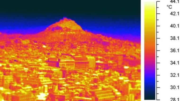
Periods of hot weather are always felt more acutely in cities, especially at night. This is down to a phenomenon called an urban heat island, where the temperature in the city can be up to 10ºC higher than the surrounding countryside. The built-up urban environment tends to act like a giant storage heater, soaking up the heat during the day and releasing it at night. Air pollution, traffic, lack of open space and low evaporation also contribute to the heat of the city. In addition, appliances such as refrigerators and air conditioners have to work harder as the temperature rises. In turn, this adds more heat to the environment causing the situation to worsen.
Prof. Kostas Kourtidis from the Democritus University of Thrace, who was in charge of the ground measurements, said, "The analysis of the dataset will allow us to better understand how urban heat islands vary in the city of Athens. This should help us come one step closer to the operational forecasting of urban temperatures at high spatial resolution." A further five flights and associated ground measurements were conducted during the ensuing week, while the Athens weather obligingly reached over 36°C. In agreement with the National Technical University of Athens and the Scientific Committee of the Acropolis Archaeological Site, the ground teams took extra in situ measurements on the Acropolis itself.
Once analysed, the dataset will address a number of specific objectives; namely the quality assessment of urban heat island information products, the development of urban heat wave forecasting techniques, the development of appropriate alert systems and the detailed study of the phenomenon's spatial variability in metropolitan areas, which may help improve urban planning in the future to reduce the effects of heat waves.
Image: Thermal image of Lycabettus hill rising out of central Athens. From the image it is clear to see how the urban environment of Athens has retained heat to create an urban heat island. Much of the fabric of the city is storing temperatures of over 40°C. (Image Courtesy: Thermopolis 2009 team, ESA)

Value staying current with geomatics?
Stay on the map with our expertly curated newsletters.
We provide educational insights, industry updates, and inspiring stories to help you learn, grow, and reach your full potential in your field. Don't miss out - subscribe today and ensure you're always informed, educated, and inspired.
Choose your newsletter(s)


