3D Modelling of a Cadastral Treasure in Slovenia
Towards a 3D Cadastre in Slovenia
In the last decade, there has been a significant global trend towards 3D real property cadastres. Besides the legal framework, the modelling and graphical representation of 3D real property units have gained an important place on the research and development agenda. This Slovenian case illustrates what a ‘data treasure’ is: the cadastral and other spatial data within the national spatial data infrastructure for generation of 3D real property graphical models within a 3D cadastre.
The roots of the Slovenian land administration system lie in the traditional parcel-oriented dual Austrian system, divided into the land surveying part (cadastre) and the legal part (land registry). The first systematic cadastral land surveying was carried out during the Austrian Empire, based on the Grundsteuerpatent (Land Taxation Act) from 1817. Initially established for taxation purposes, the land cadastre took on an important legal function with a formal linkage to the land registry in 1871 with the Grundbuchsgesetz (Land Registry Act).
Records and registration of property rights related to land and buildings originally only used 2D representation, based on parcel boundaries and building footprints. This was a major simplification of real property models. The use of land would of course be impossible if rights applied to the surface of the Earth only. A right to own or use land determined by parcel boundaries has always been related to a ‘certain space’, theoretically vertically extended from the centre of the Earth to the infinite sky, but always also restricted in the vertical dimension by other rights such as mineral and water rights, flying rights, etc.
Although real property units have always been 3D entities, their 2D graphical representation (cadastral maps) enabled transparent registration of real properties in most situations. With the increasing complexity of our built environment in particular, a requirement for additional vertical (along with the horizontal) division of space and determination of 3D real property units has emerged in the last decades. This calls for new concepts and approaches to modelling real property units within a land administration system.
Land parcels and buildings
The main principle of the current Slovenian real property legislation continues to be the Roman principle of superficies solo cedit, i.e. the building follows the legal fate of the land. Exceptions to this principle are (1) the right of superficies, which is the right to own a built structure above or beneath the land owned by a third person, and (2) apartment ownership (condominium). These two exceptions require a technical solution for recording and registering buildings and parts of buildings as real property units. The 2D graphical representation of land parcels no longer met the requirements for transparent registration and representations in all real property situations, as prescribed by law. As a consequence, the Land Cadastre was upgraded with new records: the Building Cadastre, based on legislation from 2000. Both records are nowadays maintained by the Surveying and Mapping Authority of the Republic of Slovenia and are linked with the Land Registry at the Court of Justice.
Cadastral data on buildings
In the period from 2000 to 2003, data was systematically acquired about all buildings in Slovenia. This entailed data about each building’s exterior, namely the building projection to the ground, the highest point of the building and the point representing the terrain around the building, being extracted photogrammetrically from stereopairs of aerial images. In 2003 and 2004, attribute data from the available records was added to each acquired building represented by a polygon in the national reference coordinate system. Although officially graphically represented in just two dimensions, the data from the Land Cadastre and the Building Cadastre provided the data needed to generate a 3D cadastral representation.
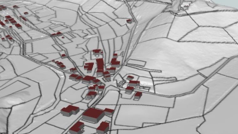
However, since the vertical coordinates were recorded as attributes for limited points (buildings), the Lidar data available within the National Spatial Data Infrastructure for the whole Slovenian territory is nowadays an important input for 3D modelling of cadastral data at Level of Detail (LoD) 1 as determined by the CityGML OGC standard. The CityGML model, presented in Figure 1, was created using:
- data from the Land Cadastre (parcel boundaries, building footprints)
- data from the Building Cadastre (vertical projection of the buildings on the ground)
- a Lidar georeferenced and classified point cloud (with a density of 10 points per square metre – the first pulse).
This case study also illustrates an option for merging both records into one with the possibility of a unique 3D graphical representation of cadastral data.
3D real property cadastre
Considering the requirements for transparent registration of 3D real property units, as can be defined within the Slovenian legislation, 3D graphical models should also be developed for ‘complex’ situations where real property units are defined with a vertical extension, e.g. example parts of a building. Before 2000, registration of property rights for an apartment or other parts of buildings was possible in the Land Registry based on a building and floor (apartment) sketch, providing appendices to the real property registration documentation. With the new legislation from 2000, the cadastral entry with floor plans and a georeferenced building footprint in the national reference coordinate system is a precondition for registration of rights and restrictions on buildings or parts of buildings in the Land Registry. For the cadastral entry, a drawing of each horizontal layer of the building, i.e. the floor plan, has to be provided. The collection of the floor plans explicitly covers the whole building.
The objective has been to provide 3D models for each real property unit to which rights, restrictions and other attributes can be assigned in the cadastres and the Land Registry. Based on the data from the Land Cadastre (building footprint) and the Building Cadastre (building outline, floor plans), the authors prepared a detailed 3D model of a selected building that had been previously divided into more real property units, i.e. apartments and common parts of the building (Figure 2).
Here, it has to be emphasised that the current cadastral archive at the surveying authority does not include vector data of floor plans; additionally, floor heights are missing. This data is therefore not publicly available, but it can be found at the archives of the land surveyors who provided the documentation for the cadastral entry. Recommendations to change the rules for recording and archiving cadastral data are currently under consideration at the surveying authority.
Complex structures
In urban areas and also in other areas with intensive human interventions, there is a tendency to use the space above and below the Earth’s surface and above and below existing structures – not only in the case of buildings but also in the case of other engineering structures. While there is still a legal barrier to form and register a 3D real property unit which is not a building (e.g. a tunnel or a bridge), the approach presented for buildings can be applied in many situations.
For illustration purposes, the authors selected an underpass in Ljubljana. Currently, the underpass is recorded only as attribute data and a floor plan in archival documentation within the Building Cadastre and is not a part of the cadastral graphical representation (Figure 3). The graphical representation of the Land Cadastre and Building Cadastre data does not indicate that there is, in fact, an underground structure. The floor plans of the underground space are saved only as attributes linked to the documentation of the Land Cadastre, which provides the basis for registering the rights to real property units in the Land Registry. This complex data structure is, in such a case, difficult to understand, and a 3D model of real property units is required in order to achieve legal certainty in relation to registering real properties.
The data and documentation needed to register underground real property units in the Land Cadastre and further in the Land Registry were used to provide a detailed 3D model, including all real property units to which cadastral and registry attributes are assigned (Figure 4).
Further challenges
The main challenge when trying to develop such detailed 3D models of real properties within the Slovenian land administration system is the incomplete Building Cadastre database. Detailed floor plans are available only for the buildings with the so-called ‘cadastral entry’ that is needed for new buildings and for registration of apartment ownership (condominium); for other buildings, only the data from the stereo photogrammetric acquisition is available. Furthermore, attention should be drawn to the data format and quality of floor plans in the Building Cadastre archive; most floor plans are still not directly available in vector format. Finally, in order to mirror the multifunctionality of the cadastre, the topology of 3D models must be considered further. This is a precondition to ensure topologically correct 3D models, and to use them for different types of spatial analysis, location-based services and other applications.
Acknowledgement
The authors would like to thank Mojca Kosmatin Fras for her contribution to this article.
Further Reading
Drobež, P., Kosmatin Fras, M., Ferlan, M., Lisec, A. (2017). Transition from 2D to 3D real property cadastre: The case of the Slovenian cadastre. Computers, Environment and Urban Systems, 62, 125–135, doi:10.1016/j.compenvurbsys.2016.11.002
Drobež, P., Grigillo, D., Lisec, A., Kosmatin Fras (2016). Remote sensing data as a potential source for establishment of the 3D cadastre in Slovenia. Geodetski vestnik, 60 (3), 392–422, doi: 10.15292/geodetski-vestnik.2016.03.392-422

Value staying current with geomatics?
Stay on the map with our expertly curated newsletters.
We provide educational insights, industry updates, and inspiring stories to help you learn, grow, and reach your full potential in your field. Don't miss out - subscribe today and ensure you're always informed, educated, and inspired.
Choose your newsletter(s)


