Turning UAV and Lidar into Something Beautiful
YellowScan International User Conference 2017
Mounting Lidar on an unmanned airborne vehicle (UAV) is regarded by many as the next geospatial frontier, but gradually the barriers are being overcome. Scientists and Lidar- and UAV-adopters from surveying companies gathered at the second YellowScan User Conference in Montpellier, France, to discuss the future of this novel and promising geodata acquisition technology. The diverse backgrounds of the over 80 attendees reflect the potential of equipping UAVs with Lidar sensors, resulting in what may be called UAS-Lidar.
The venue – Château de Flaugergues, built between 1696 and 1730 – added an extra dimension to the two-day conference, held on 29 and 30 June. The conference included demonstrations, workshops and presentations on geo-data collection with UAS-Lidar as well as the processing and analysis of the acquired point clouds. Various challenging case studies were presented. The participants were also provided with an update on what’s new and what’s forthcoming at YellowScan.
YellowScan
The conference was kicked off by Pierre d’Hauteville, head of sales and marketing at the company. Next, Michel Assenbaum, president of YellowScan and its mother company L’Avion Jaune, highlighted the history of the company. L’Avion Jaune was founded in 2005, aiming at developing aerial high-end imaging services in France. Having observed a market for UAS geo-data acquisition technologies Assenbaum together with Tristan Allouis, both engineers holding a PhD degree, started YellowScan in 2012. In 2013, a first prototype of an airborne Lidar system mounted on a UAS was tested resulting in the commercial launch of the YellowScan Mapper in 2014 and followed by the Surveyor UAS-Lidar system in 2016. This was also the year in which the first international user conference was held. YellowScan aims at designing, developing and producing unmanned airborne Lidar systems for professionals across the world.
Keynote and Workshop
Omar-Pierre Soubra, director of marketing communications for Trimble, delivered a keynote entitled ‘The Future of Geospatial’, bringing us from the history of Lidar, via self-driving cars, data processing with artificial intelligence to new infrastructures and the hyperloop. The latter is a proposed solution for transporting people and freight in a pod-like vehicle propelled through a reduced-pressure tube at airliner speed. He ended with looking at geomatics companies that will survey the planet Mars. A workshop by Arttu Soininen of Terrasolid was one of the highlights. Mr Soininen focused on the capabilities of TerraScan for automatic classification of roof, roof structures, walls, wall structures, trees, vegetation, poles and cars. The underlying method is based on grouping of points to segments and objects through exploring the local geometric structure. In this way adjacent points lying on a planar surface are grouped as belonging to a wall or a roof. Also the spacing between points and the appearance as a pole-like object are used in the classification process. An important application is the mapping of individual trees, which enables the calculation of the height and canopy width of each tree and to count the trees. Adding multispectral data to the points allows automatic recognition of tree species. These capabilities help managers to maintain a tree database of a city and to decide which trees in a forest to cut.
Demos
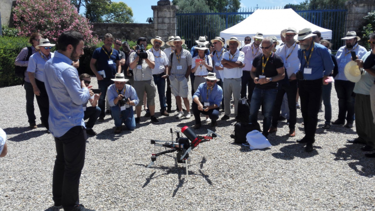
During a live demonstration on the first day the château and garden were captured with a YellowScan Surveyor Lidar system (weight: 1.6kg, dimensions: 100mm x 150mm x 140mm) mounted on the Six3 from Escadrone, a rotary wing with six rotors. Since the system is equipped with a parachute and weighs less than 6.5kg, flights in urban areas are permitted according to the French drone regulation. The operational speed of the Surveyor Lidar system is typically 15 to 75km/h, its flying height 10 to 60m and its swath width 30 to 120m. The Lidar sensor emits 300,000 laser pulses per second. These pulses have a wavelength of 905nm, which lies in the near infrared part of the electromagnetic spectrum and are thus invisible for the human eye. The onboard GNSS receiver can trace 220 GNSS channels from three operational constellations including GPS, GLONASS and BeiDou. The acquired point clouds were visualised in real-time on a TV screen with the YellowScan LiveStation software, and processed and classified using Trimble RealWorks. Point clouds from three different sources were mixed: the YellowScan Surveyor, the Trimble SX10 scanning total station, and the GeoSlam handheld scanner, which made it possible to show the interior of the château. The second day started with a field trip to the prehistoric site of Cambous, where humans settled as early as 2,500 years BC. This site was more challenging than the one the day before, as there was lots of vegetation covering the ground surface, buildings and other objects. Again the Surveyor Lidar system was used, but now mounted on the OnyxStar FOXC8 HD from AltiGator, as the Six3 also a rotary wing but with eight rotors. A point cloud of the site captured a few weeks before the start of the conference was processed by Martin Isenburg of rapidlasso, the creator of LAStools and LASzip. Since he never visited the site before, Isenburg had to analyse the point cloud without scene knowledge. A challenging job, particularly because some surfaces did not deliver returns, such as the roof of a small cabin, covered with wire netting. The post-processing resulted in a Digital Surface Model, and a ground-filtered Digital Elevation Model (DEM) for forestry applications.
Case Studies
Several case studies were presented during parallel sessions. Isabelle Heitz (AIRD'ECO) discussed a survey with the YellowScan Mapper aimed at mapping a hillfort. The Roman site Camp de César, located near Paris, France, is covered by a dense boxwood, ruling out a terrestrial survey. The UAS-Lidar survey resulted in 28 million points (140 points/m²) with a height accuracy better than 20cm. From the point cloud a DEM was generated which acted as a source for derived products such as a contour map with 1m interval and profiles.
Dr Akira Kato, Chiba University, Japan, placed UAS-Lidar in the broader context of various geo-data acquisition technologies, including airborne Lidar and terrestrial laser scanning for forest monitoring purposes in general and the determination of tree growth in particular. He concluded that UAS-Lidar has to capability to improve the accuracy of forest monitoring. UAS-Lidar also contributes to better risk management of forest fires.
Doyle McKey, University of Montpellier, and Cédric Krasnopolski, L’Avion Jaune, discussed the mapping of pre-Columbian raised fields in Bolivia using UAS-Lidar. The aim of the mapping was to find out how abandoned mounds – artificial hills created centuries back by indigenous people – could survive the fires during the dry season and the three to four metres of heavy rain falls during the annual rainy season. Lidar enabled the collection of data of the ground surface of the wooded area. From the DEM created using the Lidar point cloud, slope, surface, diameter and height of the mounds, could be computed – all being information which helps to resolve the puzzle.
Panel Discussion
The attendees appreciated the ample opportunities for discussion and exchanging ideas and prospects. At the end of the first day Tim Roorda, director of solutions engineering at Juniper Unmanned, led a panel discussion. The panellists consisted of Omar-Pierre Soubra, Michel Assenbaum, Dr Akira Kato and Wim van Wegen. The discussion focussed on the present status quo, the upcoming challenges to make a success of UAS-Lidar and the seemingly limitless number of applications that are coming into sight. The questions and discussions underlined the high commitment for UAS-Lidar of the participants. Indeed, UAS-Lidar is a truly promising surveying technique and only time will tell which applications will be most successful.
Acknowledgement
The author would like to thank Mathias Lemmens, senior editor of GIM International, for his valuable feedback.
Further Information
A demonstration of the YellowScan Surveyor Lidar system mounted on the Six3 from Escadrone in operation and the resulting point cloud and products can be viewed below.
Further Reading
- Lemmens, M. (2017) The Fierce Rise of Airborne Lidar: a View on Status, Developments and Trends, GIM International, 31(1), pp. 16-19.
- Lemmens, M. (2014) UAS for Mapping - A product survey on systems and features, GIM International, UAS Special, pp. 12-16.
- Lemmens, M. (2014) UAS Technology in Focus, GIM International, UAS Special, pp. 17-18.
YellowScan will be exhibiting at Intergeo (26-28 September 2017, Berlin) in hall 4.1, stand no. D4.050.

Value staying current with geomatics?
Stay on the map with our expertly curated newsletters.
We provide educational insights, industry updates, and inspiring stories to help you learn, grow, and reach your full potential in your field. Don't miss out - subscribe today and ensure you're always informed, educated, and inspired.
Choose your newsletter(s)


