UAS as a Tool for Surveyors
From Tripods and Trucks to Virtual Surveying
Since 2011, the use of Unmanned Aerial Systems (UAS) as complementary surveying devices has mushroomed. With resolutions as high as 1cm, the resulting imagery enables the highly automated production of detailed elevation data, orthophotos and 3D virtual landscapes. However, the gains in efficiency during data acquisition are accompanied by data management challenges and processing efforts which surveyors often underestimate. Here, the authors demonstrate how surveyors can make UAS technology economically feasible by balancing massive data volumes without compromising the quality of feature extraction.
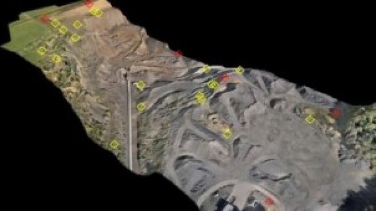
| GCPs (red) and check points (yellow) distributed over a quarry. |
The field surveyor intelligently selects lines and points to correctly and economically capture terrain features in three dimensions. His main task is to balance level of detail (or number of points) and quality. Choosing too many points adds to costs, yet too few points will impede completeness and accuracy. Finding the proper balance relies on the human capacity to analyse the terrain while standing in the midst of it. Field surveys directly result in vector data: point features such as lamp posts or property corners, line features such as tops of ditches or centres of roads, and polygons such as property parcels and lakes. Vector data requires minimal post-processing in the office to obtain the specified end product; the field work itself is the most labour-intensive part.
Virtual Surveying
UAS surveys do not directly produce vector data. The survey starts with flight planning and aerial survey, resulting in digital images which cover the selected area at approximately equal resolution. Unlike with field surveys, no lines and points are captured during an aerial survey. Instead, this job has to be conducted in the office afterwards using orthophotos and Digital Elevation Models (DEM), both of which can be generated automatically using the proper software.
A typical ground sampling distance (GSD) of a few centimetres results in massive data volumes even when the area to be covered is just a few hectares. For example, a GSD of 2cm results in 2,500 pixels per square metre, which is equivalent to 25 million pixels per hectare. The challenge is to balance data volume with efficiency in feature extraction without loss of quality. Virtual surveying is a solution to this challenge. An easy-to-learn user interface allows intelligent, efficient and accurate feature extraction from realistic visualisations of topographic data (Figure 1).
Surveying in the Model
Virtual surveying is done in a 3D model which resembles the actual terrain. The surveyor can navigate through the model and measure points by clicking the mouse, just as if he were placing a survey rod over a terrain point. A virtual environment shows the orthophoto draped over the DEM and enables the landscape to be viewed from many different viewpoints. The combination of orthophoto and DEM offers many advantages
| Designing a noise barrier in a virtual landscape. |
compared to ‘heads-up’ digitisation of orthophotos alone. The viewpoint can be easily changed to obtain an optimum perspective of the feature of interest, and zooming and roaming enables terrain features to be interpreted reliably and measured accurately. The surveyor can easily move around or jump over houses, trees, hedges and other obstructions. Furthermore, the 3D representation enables much easier detection of features than the conventional photogrammetric approach. The result is a better and more efficient identification and measurement of features compared to field surveying or conventional photogrammetry.
The full article is online at http://member.gim-international.com. Please subscribe for free using the Subscribe button in the left hand column.

Value staying current with geomatics?
Stay on the map with our expertly curated newsletters.
We provide educational insights, industry updates, and inspiring stories to help you learn, grow, and reach your full potential in your field. Don't miss out - subscribe today and ensure you're always informed, educated, and inspired.
Choose your newsletter(s)


