UAS-based Measurement of Crop Height and Biomass
Monitoring Crop Growth and Estimating Yield Production in Precision Farming
Monitoring crop growth provides timely and reliable spatial information to farmers and decision-makers employed in precision agriculture. The authors of this article tested the usability of UAS RGB images for estimating crop heights and biomass. The assessment was done at eight growth stages to provide timely and reliable spatial information.
Studying growth of crops throughout the growing season is a prerequisite for informed farming, decision-making and estimating yield production. Measuring the evolution of crop height and biomass during the growing season provides the essential indicators for growth and health and thus provides a means for dedicated irrigation, fertilisation and estimation of yield. Field-based data acquisition is able to give accurate results but is costly and time-consuming which can lead to under-sampling and thus compromise accuracy. Added to this, data acquisition in the field causes damage to the vegetation due to trampling. Therefore, non-destructive methods of measuring changes in crop height over time at high spatial and temporal resolution are essential.
UAS
Changes in crop height can be determined from time series of digital surface models (DSMs) generated from overlapping images. Changes in biomass can be computed from vegetation indices which are also a good indicator for crop health. Multispectral satellite images are well-suited for this purpose, but they are expensive – as are aerial images captured from manned aircraft. Images captured using unmanned aerial systems (UASs) equipped with a camera have emerged as an alternative to expensive satellite or airborne data. Flying at a low altitude, camera-equipped UASs can acquire high temporal and spatial-resolution aerial images of small or medium-sized agricultural fields for a reasonable price and without causing damage to the crops.
Data Acquisition and Processing
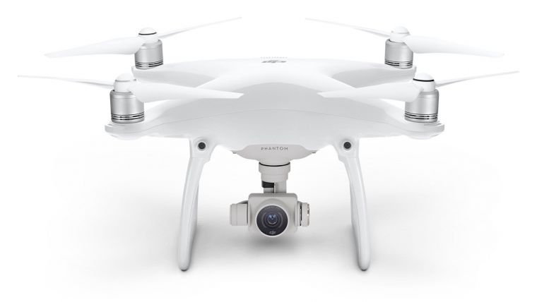
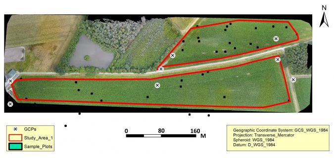
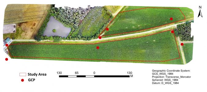
To test the feasibility of using UASs for crop monitoring, a study has been conducted on a maize field of 14ha in Gronau, western Germany. A UAS-based workflow suited for crop monitoring includes flight planning, selection and measurement of ground control points (GCPs), conducting flights, generating a digital surface model (DSM) and an orthomosaic, and exploring the spectral image information. The UAS used is a Phantom-4, an inexpensive quadcopter equipped with a stabilised CanonEOS600D camera (Figure 1). The focal length of the camera is 3.722mm. The 4,000 x 3,000 pixels produce images in the RGB part of the electromagnetic spectrum, i.e. red, green and blue. To enable georeferencing of the images, eight ground control points (GCPs) were measured using a Leica CS10 field controller with a positional accuracy of 2cm. The majority of the GCPs were unevenly distributed along the border of the field, while a few GCPs were located inside the field, which unfortunately made them increasingly less visible as the growing season progressed (Figure 2). Eight flights were conducted during the whole growing season from May to September 2016 in the morning hours. The time interval between two flights was 10 to 15 days; the variability in time interval was mainly due to weather conditions. The images were taken with 80% forward and 60% side overlap and processed with Pix4D to generate a DSM and an orthomosaic (Figure 3). The collection of ground truth data was done by a field survey at 40 spots well distributed over the maize field. The crop heights were measured with measuring tape during the eight growth stages. Crop samples were collected at the same 40 spots at harvest time as ground truth for determining the biomass using the weighing balance method. The DSMs formed the basis for the generation of the crop surface models (CSMs) for crop height estimation.
Crop Surface Models
The eight DSMs were used as CSMs representing the surface of the crops. At each time interval, the crop height was determined by calculating the difference between the CSM and a digital elevation model (DEM) representing the ground surface. This DEM was generated from the first flight when the maize seeds were sprouting and thus the bare ground was actually captured. The average crop height obtained from the CSMs and the field-measured crop height at each sample spot during the eight growing stages were used to determine the accuracy of crop heights. The comparison revealed an accuracy of between 68% and 85% and a root mean square error (RMSE) of 30cm to 24cm respectively. Higher accuracy of crop heights can be obtained by using more GCPs than the eight used in the present pilot. These GCPs should also be well distributed along the field border and highly visible. Small systematic errors occurred due to the decreasing visibility of GCPs inside the field and also because of repetitive patterns caused by maize being sown in rows which sometimes impeded image matching.
Biomass
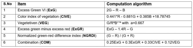
Biomass is an important parameter for efficient crop management during the growing season and for yield estimation. Vegetation indices provide an indication of the biomass as well as the health status of the crops at different growth stages. From the RGB images, vegetation indices were calculated exploring various ratio, summation and band difference computations (see Figure 4), using ENVI (band math tool) and QGIS (Semi-automatic Classification Plugin, SCP) software. These vegetation indices were selected based on the available spectral bands and their suitability for crops like maize. Combining biomass estimates with crop height at the various growth stages enables estimation of fresh and dry biomass at harvest time. The best estimation of biomass at harvest time is obtained from crop height and biomass estimates halfway through crop growth, i.e. the period between stem elongation and inflorescence emergence.
Future outlook
The CSMs generated could be the main error source for accurate crop height measurement. Improvement can be achieved by placing sufficiently well-distributed GCPs over the entire field which remain visible during the entire growing season. It is worthwhile studying the abilities of direct georeferencing without using GCPs by mounting a high-accuracy GNSS receiver on board the UAS. To improve the estimation of the biomass it is recommend to mount a near-infrared (NIR) camera alongside the RGB camera. NIR can provide a clear picture of crop health and moisture variations and also enables visual interpretation and digital analysis.
Further Reading
Tumlisan, G.Y., Bronsveld, M.C., Koeva, M.N. (2017) Monitoring growth development and yield estimation of maize using very high-resolution UAV images in Gronau, Germany. (ITC)

Value staying current with geomatics?
Stay on the map with our expertly curated newsletters.
We provide educational insights, industry updates, and inspiring stories to help you learn, grow, and reach your full potential in your field. Don't miss out - subscribe today and ensure you're always informed, educated, and inspired.
Choose your newsletter(s)


